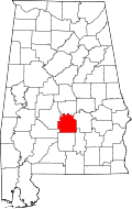
Fort Deposit, Alabama | |
---|---|
Coordinates: 31°59′16″N86°34′16″W / 31.98778°N 86.57111°W | |
Country | United States |
State | Alabama |
County | Lowndes |
Area | |
• Total | 5.66 sq mi (14.66 km2) |
• Land | 5.66 sq mi (14.66 km2) |
• Water | 0.00 sq mi (0.00 km2) |
Elevation | 466 ft (142 m) |
Population (2020) | |
• Total | 1,225 |
• Density | 216.39/sq mi (83.54/km2) |
Time zone | UTC-6 (Central (CST)) |
• Summer (DST) | UTC-5 (CDT) |
ZIP code | 36032 |
Area code | 334 |
FIPS code | 01-27520 |
GNIS feature ID | 0118518 |
Fort Deposit is a town in Lowndes County, Alabama, United States. Since 1890, it has been the largest town in Lowndes County. [2] At the 2010 census the population was 1,344, up from 1,270 in 2000. It is part of the Montgomery Metropolitan Statistical Area.
This town is named after a fort that was built under the order of General Andrew Jackson. This was a supply fort that was built to serve the soldiers during the Creek Indian War. There is an annual arts and crafts fair called Calico Fort on the second weekend of April every year.
It was incorporated on February 13, 1891. It reportedly sits on the highest point of land between Montgomery and New Orleans, Louisiana. [3]
Fort Deposit is located at 31°59′16″N86°34′16″W / 31.98778°N 86.57111°W (31.987872, -86.571249). [4]
According to the U.S. Census Bureau, the town has a total area of 5.6 square miles (15 km2), all land.
According to the Köppen climate classification, Fort Deposit has a humid subtropical climate (abbreviated Cfa).
Climate data for Fort Deposit, 1991–2020 simulated normals (486 ft elevation) | |||||||||||||
---|---|---|---|---|---|---|---|---|---|---|---|---|---|
Month | Jan | Feb | Mar | Apr | May | Jun | Jul | Aug | Sep | Oct | Nov | Dec | Year |
Mean daily maximum °F (°C) | 58.1 (14.5) | 62.1 (16.7) | 69.3 (20.7) | 76.1 (24.5) | 83.1 (28.4) | 88.5 (31.4) | 90.9 (32.7) | 90.3 (32.4) | 86.5 (30.3) | 77.7 (25.4) | 67.5 (19.7) | 59.7 (15.4) | 75.8 (24.3) |
Daily mean °F (°C) | 46.8 (8.2) | 50.4 (10.2) | 57.2 (14.0) | 63.7 (17.6) | 71.8 (22.1) | 78.1 (25.6) | 80.8 (27.1) | 80.1 (26.7) | 75.7 (24.3) | 65.8 (18.8) | 55.4 (13.0) | 48.9 (9.4) | 64.6 (18.1) |
Mean daily minimum °F (°C) | 35.4 (1.9) | 38.7 (3.7) | 45.0 (7.2) | 51.4 (10.8) | 60.3 (15.7) | 67.6 (19.8) | 70.7 (21.5) | 70.0 (21.1) | 65.1 (18.4) | 53.8 (12.1) | 43.2 (6.2) | 38.1 (3.4) | 53.3 (11.8) |
Average precipitation inches (mm) | 5.25 (133.30) | 4.84 (122.97) | 5.39 (136.78) | 4.55 (115.67) | 3.87 (98.27) | 4.96 (125.99) | 5.08 (128.97) | 4.75 (120.58) | 4.01 (101.80) | 3.32 (84.32) | 4.38 (111.31) | 5.40 (137.16) | 55.8 (1,417.12) |
Average dew point °F (°C) | 37.6 (3.1) | 40.5 (4.7) | 45.5 (7.5) | 52.2 (11.2) | 60.6 (15.9) | 68.0 (20.0) | 70.9 (21.6) | 70.3 (21.3) | 65.8 (18.8) | 55.8 (13.2) | 46.2 (7.9) | 41.0 (5.0) | 54.5 (12.5) |
Source: PRISM Climate Group [5] |
Census | Pop. | Note | %± |
---|---|---|---|
1880 | 350 | — | |
1890 | 518 | 48.0% | |
1900 | 1,078 | 108.1% | |
1910 | 893 | −17.2% | |
1920 | 830 | −7.1% | |
1930 | 1,092 | 31.6% | |
1940 | 1,351 | 23.7% | |
1950 | 1,358 | 0.5% | |
1960 | 1,466 | 8.0% | |
1970 | 1,438 | −1.9% | |
1980 | 1,519 | 5.6% | |
1990 | 1,240 | −18.4% | |
2000 | 1,270 | 2.4% | |
2010 | 1,344 | 5.8% | |
2020 | 1,225 | −8.9% | |
U.S. Decennial Census [6] 2013 Estimate [7] |
Race / Ethnicity (NH = Non-Hispanic) | Pop 2010 [8] | Pop 2020 [9] | % 2010 | % 2020 |
---|---|---|---|---|
White alone (NH) | 315 | 244 | 23.44% | 19.92% |
Black or African American alone (NH) | 1,012 | 942 | 75.30% | 76.90% |
Native American or Alaska Native alone (NH) | 1 | 0 | 0.07% | 0.00% |
Asian alone (NH) | 2 | 3 | 0.15% | 0.24% |
Pacific Islander alone (NH) | 0 | 0 | 0.00% | 0.00% |
Some Other Race alone (NH) | 0 | 0 | 0.00% | 0.00% |
Mixed Race or Multi-Racial (NH) | 8 | 23 | 0.60% | 1.88% |
Hispanic or Latino (any race) | 6 | 13 | 0.45% | 1.06% |
Total | 1,344 | 1,225 | 100.00% | 100.00% |
At the 2010 census there were 1,344 people, 512 households, and 348 families in the town. The population density was 240 inhabitants per square mile (93/km2). There were 592 housing units at an average density of 105.7 per square mile (40.8/km2). The racial makeup of the town was 75.5% Black or African American, 23.7% White and 0.6% from two or more races. 0.4% of the population were Hispanic or Latino of any race. [10] Of the 512 households 28.9% had children under the age of 18 living with them, 34.8% were married couples living together, 29.3% had a female householder with no husband present, and 32.0% were non-families. 28.9% of households were one person and 11.2% were one person aged 65 or older. The average household size was 2.63 and the average family size was 3.28.
The age distribution was 29.5% under the age of 18, 9.6% from 18 to 24, 22.1% from 25 to 44, 26.6% from 45 to 64, and 12.2% 65 or older. The median age was 34.3 years. For every 100 females, there were 86.9 males. For every 100 women age 18 and over, there were 76.7 men.
The median household income was $30,000 and the median family income was $31,591. Males had a median income of $41,579 versus $25,341 for females. The per capita income for the town was $14,411. About 19.4% of families and 22.2% of the population were below the poverty line, including 43.6% of those under age 18 and 25.4% of those age 65 or over.
At the 2000 census there were 1,270 people, 489 households, and 349 families in the town. The population density was 225.1 inhabitants per square mile (86.9/km2). There were 569 housing units at an average density of 100.9 per square mile (39.0/km2). The racial makeup of the town was 68.19% Black or African American, 31.50% White and 0.31% from two or more races. 0.47% of the population were Hispanic or Latino of any race. [11] Of the 489 households 35.0% had children under the age of 18 living with them, 39.3% were married couples living together, 27.4% had a female householder with no husband present, and 28.6% were non-families. 25.6% of households were one person and 9.6% were one person aged 65 or older. The average household size was 2.60 and the average family size was 3.12.
The age distribution was 29.8% under the age of 18, 8.6% from 18 to 24, 27.1% from 25 to 44, 21.7% from 45 to 64, and 12.8% 65 or older. The median age was 35 years. For every 100 females, there were 86.2 males. For every 100 women age 18 and over, there were 83.0 men.
The median household income was $20,433 and the median family income was $24,250. Males had a median income of $27,391 versus $20,882 for females. The per capita income for the town was $12,584. About 29.8% of families and 35.3% of the population were below the poverty line, including 42.8% of those under age 18 and 34.2% of those age 65 or over.
Butler County is a county located in the south central portion of the U.S. state of Alabama. As of the 2020 census, the population was 19,051. Its county seat is Greenville. Its name is in honor of Captain William Butler, who was born in Virginia and fought in the Creek War, and who was killed in May 1818.
Covington County, is a county located in the south central portion of the U.S. state of Alabama. As of the 2020 census the population was 37,570. Its county seat is Andalusia. Its name is in honor of Brigadier General Leonard Covington of Maryland and Mississippi, who died in the War of 1812.
Crenshaw County is a county located in the south central portion of the U.S. state of Alabama. It is located immediately south of the Montgomery metropolitan area. As of the 2020 census, the population was 13,194. Its county seat is Luverne. Its name is in honor of an Alabama judge, Anderson Crenshaw.
Lamar County is a county in the U.S. state of Alabama. As of the 2020 census, the population was 13,972. Its county seat is Vernon and it is a dry county. It is named in honor of Lucius Quintus Cincinnatus Lamar, a former Confederate officer and former member of both houses of the United States Congress from Mississippi.
Lowndes County is in the central part of the U.S. state of Alabama. As of the 2020 census, the county's population was 10,311. Its county seat is Hayneville. The county is named in honor of William Lowndes, a member of the United States Congress from South Carolina.
Marshall County is a county of the state of Alabama, United States. As of the 2020 census the population was 97,612. Its county seat is Guntersville. A second courthouse is in Albertville. Its name is in honor of John Marshall, famous Chief Justice of the United States. Marshall County is a dry county, with the exception of the five cities of Albertville, Arab, Grant, Guntersville, and Boaz. Marshall County comprises the Albertville, AL Micropolitan Statistical Area, which is also included in the Huntsville-Decatur-Albertville, AL Combined Statistical Area.
Ridgeville is a town in Etowah County, Alabama, United States. It incorporated in 1969 and is part of the Gadsden Metropolitan Statistical Area. At the 2020 census the population was 83, down from 158 in 2000. It is noteworthy for being the only community in Etowah County to have a black majority. Since 1970, it has also been the least populated community wholly within the county.
Sardis City is a town in Etowah and Marshall counties in the U.S. state of Alabama. It is part of the Gadsden Metropolitan Statistical Area. It originally incorporated in May 1963 under the name of "Sardis". It became Sardis City in the 1980s. At the 2020 census, the population was 1,814.
Gordonville is a town in Lowndes County, Alabama, United States. At the 2010 census the population was 326, up from 318 in 2000. It is part of the Montgomery Metropolitan Statistical Area. It incorporated effective January 20, 1990.
Hayneville is a town in Lowndes County, Alabama, United States and its county seat. At the 2010 census the population was 932, down from its record high of 1,177 in 2000. It is also part of the Montgomery Metropolitan Statistical Area. It initially incorporated in 1831, but lapsed, finally reincorporating in 1967. Before 1970, the town appeared only twice on the U.S. Census: in 1850 and 1890. The 1850 estimate of 800 residents ranked it as the largest town in the county at the time.
Lowndesboro is a town in Lowndes County, Alabama, United States. At the 2010 census the population was 115, down from 140 in 2000. It is part of the Montgomery Metropolitan Statistical Area. Although initially incorporated in 1856 by an act of the state legislature, it lapsed and was not reincorporated until 1962.
Mosses is a town in Lowndes County, Alabama, United States. At the 2010 census the population was 1,029, down from 1,101 in 2000. It is part of the Montgomery Metropolitan Statistical Area. It incorporated in 1979.
White Hall is a town in Lowndes County, Alabama, United States. The community was named for a plantation that was destroyed in an 1882 tornado. At the 2010 census the population was 858, down from its record high of 1,014 in 2000. It is part of the Montgomery Metropolitan Statistical Area.
Pelham is a city in Shelby County, Alabama, United States. The population was 24,318 at the 2020 census, It incorporated on July 10, 1964 and is a suburb located in the Birmingham metropolitan area, Alabama which was home to nearly 1.2 million residents as of the 2020 census. It was named for Confederate Civil War officer John Pelham.
Oak Hill is a town in Wilcox County, Alabama, United States. According to the 1940 U.S. Census, it incorporated in 1938. Per the 2020 census, the population was 14. It is the smallest incorporated town in Alabama as of 2020, succeeding McMullen. The smallest unincorporated census-designated place in the state is also located in Wilcox County, that of Catherine, which had 22 residents as of 2010. With a median household income of $9,286, Oak Hill is the poorest community in Alabama.
Pine Apple is a town in Wilcox County, Alabama, United States. It incorporated in 1872. Per the 2020 census, the population was 143. It has two places on the National Register of Historic Places, the Hawthorne House and the Pine Apple Historic District.
Paxton is a town in Walton County, Florida, United States. Located near Britton Hill on the Alabama–Florida state line, it has the highest elevation of any in Florida. The Town of Paxton is located on the Florida Panhandle, and is part of the Crestview–Fort Walton Beach–Destin metropolitan area. The population was 556 as of the 2020 census.
Beaver Creek Township is a civil township of Crawford County in the U.S. state of Michigan. As of the 2010 census, the township population was 1,736.
New Haven is a town in Mason County, West Virginia, United States, along the Ohio River. The population was 1,485 at the 2020 census. It is part of the Point Pleasant, WV–OH Micropolitan Statistical Area.
Reserve Township is a township in Allegheny County, Pennsylvania, United States. The population was 3,333 at the 2010 census.