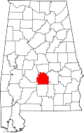
Mosses, Alabama | |
---|---|
Coordinates: 32°10′23″N86°40′38″W / 32.17306°N 86.67722°W | |
Country | United States |
State | Alabama |
County | Lowndes |
Area | |
• Total | 4.78 sq mi (12.37 km2) |
• Land | 4.74 sq mi (12.28 km2) |
• Water | 0.03 sq mi (0.09 km2) |
Elevation | 207 ft (63 m) |
Population (2020) | |
• Total | 834 |
• Density | 175.88/sq mi (67.90/km2) |
Time zone | UTC-6 (Central (CST)) |
• Summer (DST) | UTC-5 (CDT) |
ZIP code | 36040 [2] |
Area code | 334 |
FIPS code | 01-51520 |
GNIS feature ID | 0136404 |
Mosses is a town in Lowndes County, Alabama, United States. At the 2010 census the population was 1,029, down from 1,101 in 2000. It is part of the Montgomery Metropolitan Statistical Area. It incorporated in 1979. [3]
Mosses is located at 32°10′23″N86°40′38″W / 32.17306°N 86.67722°W (32.173120, -86.677296). [4]
According to the U.S. Census Bureau, the town has a total area of 4.8 square miles (12 km2), all land.
Census | Pop. | Note | %± |
---|---|---|---|
1970 | 158 | — | |
1980 | 649 | 310.8% | |
1990 | 1,072 | 65.2% | |
2000 | 1,101 | 2.7% | |
2010 | 1,029 | −6.5% | |
2020 | 834 | −19.0% | |
U.S. Decennial Census [5] 2013 Estimate [6] |
Race / Ethnicity | Pop 2010 [7] | Pop 2020 [8] | % 2010 | % 2020 |
---|---|---|---|---|
White alone (NH) | 15 | 8 | 1.46% | 0.96% |
Black or African American alone (NH) | 995 | 804 | 96.70% | 96.40% |
Native American or Alaska Native alone (NH) | 0 | 0 | 0.00% | 0.00% |
Asian alone (NH) | 0 | 0 | 0.00% | 0.00% |
Pacific Islander alone (NH) | 0 | 0 | 0.00% | 0.00% |
Some Other Race alone (NH) | 0 | 0 | 0.00% | 0.00% |
Mixed Race/Multi-Racial (NH) | 0 | 17 | 0.00% | 2.04% |
Hispanic or Latino (any race) | 19 | 5 | 1.85% | 0.60% |
Total | 1,029 | 834 | 100.00% | 100.00% |
At the 2010 census there were 1,029 people, 369 households, and 270 families in the town. The population density was 214.4 inhabitants per square mile (82.8/km2). There were 409 housing units at an average density of 85.2 per square mile (32.9/km2). The racial makeup of the town was 97.9% Black or African American, 1.5% White, 0.0% Native American, 0.0% Asian, and 0.1% from two or more races. 1.8% of the population were Hispanic or Latino of any race. [9] Of the 369 households 23.8% had children under the age of 18 living with them, 24.1% were married couples living together, 42.5% had a female householder with no husband present, and 26.8% were non-families. 25.5% of households were one person and 6.5% were one person aged 65 or older. The average household size was 2.79 and the average family size was 3.38.
The age distribution was 26.7% under the age of 18, 11.4% from 18 to 24, 25.3% from 25 to 44, 26.4% from 45 to 64, and 10.2% 65 or older. The median age was 34.7 years. For every 100 females, there were 86.8 males. For every 100 females age 18 and over, there were 88.1 males.
The median household income was $13,750 and the median family income was $16,319. Males had a median income of $19,583 versus $25,833 for females. The per capita income for the town was $8,053. About 53.4% of families and 55.4% of the population were below the poverty line, including 65.1% of those under age 18 and 51.1% of those age 65 or over.
At the 2000 census there were 1,101 people, 364 households, and 281 families in the town. The population density was 230.1 inhabitants per square mile (88.8/km2). There were 421 housing units at an average density of 88.0 per square mile (34.0/km2). The racial makeup of the town was 97.82% Black or African American, 1.18% White, 0.09% Native American, 0.09% Asian, and 0.82% from two or more races. 0.45% of the population were Hispanic or Latino of any race. [10] Of the 364 households 44.8% had children under the age of 18 living with them, 25.5% were married couples living together, 45.6% had a female householder with no husband present, and 22.8% were non-families. 20.6% of households were one person and 3.6% were one person aged 65 or older. The average household size was 3.02 and the average family size was 3.50.
The age distribution was 34.6% under the age of 18, 12.9% from 18 to 24, 27.2% from 25 to 44, 17.2% from 45 to 64, and 8.2% 65 or older. The median age was 27 years. For every 100 females, there were 84.1 males. For every 100 females age 18 and over, there were 74.8 males.
The median household income was $17,031 and the median family income was $22,273. Males had a median income of $21,528 versus $16,771 for females. The per capita income for the town was $8,268. About 39.0% of families and 43.0% of the population were below the poverty line, including 54.4% of those under age 18 and 35.9% of those age 65 or over.
Coosa County is located in the east central portion of the U.S. state of Alabama. As of the 2020 census the population was 10,387. Its county seat is Rockford. Its name derives from a town of the Creek tribe and the Coosa River, which forms one of the county borders.
Selmont-West Selmont is a census-designated place (CDP) in Dallas County, Alabama, United States. At the 2020 census, the population was 2,158.
Ridgeville is a town in Etowah County, Alabama, United States. It incorporated in 1969 and is part of the Gadsden Metropolitan Statistical Area. At the 2020 census the population was 83, down from 158 in 2000. It is noteworthy for being the only community in Etowah County to have a black majority. Since 1970, it has also been the least populated community wholly within the county.
Sardis City is a town in Etowah and Marshall counties in the U.S. state of Alabama. It is part of the Gadsden Metropolitan Statistical Area. It originally incorporated in May 1963 under the name of "Sardis". It became Sardis City in the 1980s. At the 2020 census, the population was 1,814.
Argo is a town in Jefferson and St. Clair counties, Alabama, United States. It incorporated in 1987. At the 2020 census, the population was 4,368.
Midfield is a town in Jefferson County, Alabama, United States, located two miles south of the Birmingham suburb of Fairfield. It incorporated in 1953. As of the 2020 census, it had a population of 5,211.
Fort Deposit is a town in Lowndes County, Alabama, United States. Since 1890, it has been the largest town in Lowndes County. At the 2010 census the population was 1,344, up from 1,270 in 2000. It is part of the Montgomery Metropolitan Statistical Area.
Gordonville is a town in Lowndes County, Alabama, United States. At the 2010 census the population was 326, up from 318 in 2000. It is part of the Montgomery Metropolitan Statistical Area. It incorporated effective January 20, 1990.
White Hall is a town in Lowndes County, Alabama, United States. The community was named for a plantation that was destroyed in an 1882 tornado. At the 2010 census the population was 858, down from its record high of 1,014 in 2000. It is part of the Montgomery Metropolitan Statistical Area.
Pelham is a city in Shelby County, Alabama, United States. The population was 24,318 at the 2020 census, It incorporated on July 10, 1964 and is a suburb located in the Birmingham metropolitan area, Alabama which was home to nearly 1.2 million residents as of the 2020 census. It was named for Confederate Civil War officer John Pelham.
Pine Apple is a town in Wilcox County, Alabama, United States. It incorporated in 1872. Per the 2020 census, the population was 143. It has two places on the National Register of Historic Places, the Hawthorne House and the Pine Apple Historic District.
Fishhook is a census-designated place (CDP) in Matanuska-Susitna Borough, Alaska, United States. It is part of the Anchorage, Alaska Metropolitan Statistical Area. At the 2020 census the population was 5,048, up from 4,679 in 2010.
Elk Falls is a city in Elk County, Kansas, United States, along the Elk River. As of the 2020 census, the population of the city was 113.
Newburgh is a town in Penobscot County, Maine, United States. The population was 1,595 at the time of the 2020 census.
Heath Township is a civil township of Allegan County in the U.S. state of Michigan. As of the 2020 census, the township population was 3,937.
Muskegon Heights is a city in Muskegon County in the U.S. state of Michigan. The population was 9,985 at the 2020 census.
Newtown is a city in Sullivan County, Missouri, United States. The population was 113 at the 2020 census.
Carmel Hamlet, commonly known simply as Carmel, is a hamlet and census-designated place (CDP) located in the Town of Carmel in Putnam County, New York, United States. As of the 2010 census, the population was 6,817.
Trent is a town in Taylor County, Texas, United States, that was established in 1881. The population was 337 at the 2010 census. It is part of the Abilene, Texas Metropolitan Statistical Area. Trent, Texas was named in honor of West Texas pioneer and cattleman, Isaac Riley Trent.
Genoa is a town in Vernon County, Wisconsin, United States. The population was 705 at the 2000 census. The Village of Genoa is located within the town. The unincorporated community of Romance is located in the town of Genoa.