This article relies largely or entirely on a single source .(August 2025) |
Burkville, Alabama | |
|---|---|
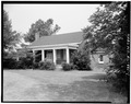
 Warren Stone House, known as Magnolia Crest, built c.1840 in Burkville | |
 Burkville  Burkville | |
| Coordinates: 32°19′41″N86°32′13″W / 32.32819°N 86.53691°W | |
| Country | United States |
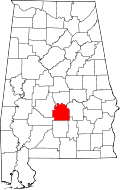
| State | Alabama |
| County | Lowndes |
| Elevation | 151 ft (46 m) |
| Time zone | UTC-6 (Central (CST)) |
| • Summer (DST) | UTC-5 (CDT) |
| Area code | 334 |
Burkville, is an unincorporated community in Lowndes County, Alabama, United States. [1]