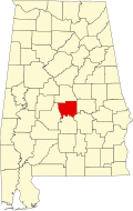
Autaugaville, Alabama

Last updated

Autaugaville, Alabama
Town of Autaugaville
Lassiter House 02.JPG
The Lassiter House in Autaugaville, which is listed on the National Register of Historic Places.
Autauga County Alabama Incorporated and Unincorporated areas Autaugaville Highlighted 0103220.svg
Location of Autaugaville in Autauga County, Alabama.
Coordinates: 32°25′56″N86°39′12″W / 32.43222°N 86.65333°W / 32.43222; -86.65333
Country United States
State Alabama
County Autauga
Founded1907
Government
  MayorCurtis Stoudemire
Area
[1]
  Total8.04 sq mi (20.82 km2)
  Land7.83 sq mi (20.29 km2)
  Water0.20 sq mi (0.53 km2)
Elevation
161 ft (49 m)
Population
 (2020)
  Total795
  Density101.49/sq mi (39.19/km2)
Time zone UTC-6 (Central (CST))
  Summer (DST) UTC-5 (CDT)
ZIP code
36003
Area code 334
FIPS code 01-03220
GNIS feature ID0113299

Autaugaville is a town in Autauga County, Alabama, United States. At the 2020 census, the population was 795. It is part of the Montgomery Metropolitan Statistical Area.

Contents

Geography

Autaugaville is located at 32°25′57″N86°39′32″W / 32.432563°N 86.658752°W / 32.432563; -86.658752 (32.432563, -86.658752). [2]

The town is located in the central part of the state along Alabama State Route 14, which runs west to east through the center of town, leading east 14 mi (23 km) to Prattville, the Autauga County seat, and west 24 mi (39 km) to Selma.

According to the U.S. Census Bureau, the town has a total area of 7.8 square miles (20 km2), of which, 7.6 square miles (20 km2) of it is land and 0.2 square miles (0.52 km2) of it is water.

History

William Thompson, [3] the first settler in what is now Autaugaville arrived around 1820 and built a gristmill and sawmill on Swift Creek, about three miles upriver from the Alabama River. One source says that the town incorporated in 1839, but another cites 1907. A cotton mill opened in 1849 on the banks of Swift Creek, and following upon the model of industrialist Daniel Pratt, the owner constructed housing for its employees, expanding the town. It grew further when many citizens from nearby Vernon relocated here to escape the floods and diseases to which that town was prone. By 1851, the town had a population of 351 and claimed four stores, two churches, and two schools.

Additional businesses opened during this period, including a cloth factory, a buggy and wagon factory, and a gristmill, making it a thriving manufacturing center. The downtown area was seriously damaged by a fire in 1853, but quickly rebuilt. The town's first and only newspaper, the Autauga Citizen, also began publication in 1853, existing until 1873.

The Civil War and Reconstruction resulted in the closing of the town's factories, including the cotton factory, which saw its shipments seized by the U.S. government. The war and its aftermath essentially ended Autaugaville's status as a manufacturing center. The town incorporated in 1907, and the Alabama Central Railroad built a branch through town in 1911. At least one of several lumber mills operated periodically until the 1930s. In 1936, an Alabama Forestry Commission nursery opened near town. Crystal Lake Manufacturing Company makes brooms, mops, and handles in Autaugaville but closed at the end of 2020. Many Autaugaville residents are employed in the automotive parts industry. [4]

Education

Autaugaville is part of the Autauga County School System and is home to Autaugaville School for prekindergarten to grade 12 students.

Emergency Services

Fire protection is provided by the Autaugaville Volunteer Fire Department.

Emergency Medical Services are provided by Haynes Ambulance.

Law enforcement agency is the Autauga County Sheriffs Office.

Demographics

Town of Autaugaville

Historical population
CensusPop.Note
1910 313
1920 36215.7%
1930 45024.3%
1940 4561.3%
1950 4590.7%
1960 440−4.1%
1970 87097.7%
1980 843−3.1%
1990 681−19.2%
2000 82020.4%
2010 8706.1%
2020 795−8.6%
U.S. Decennial Census [5]

Autaugaville first appeared on the census as an incorporated town in 1910. [6] See Autaugaville Precinct below.

2020 Census data

Autaugaville racial composition [7]
RaceNum.Perc.
White (non-Hispanic)21927.55%
Black or African American (non-Hispanic)53166.79%
Native American 30.38%
Asian 10.13%
Other/Mixed 324.03%
Hispanic or Latino 91.13%

As of the 2020 United States census, there were 795 people, 444 households, and 299 families residing in the town.

2010 Census data

As of the census [8] of 2010, there were 870 people, 350 households, and 243 families residing in the town. The population density was 114.2 inhabitants per square mile (44.1/km2). There were 412 housing units at an average density of 54.1 per square mile (20.9/km2). The racial makeup of the town was 66.8% Black or African American, 31.3% White, 0.2% Native American, 0.3% from other races, and 1.4% from two or more races. 0.8% of the population were Hispanic or Latino of any race.

There were 350 households, of which 29.4% had children under the age of 18 living with them, 38.6% were married couples living together, 4.9% had a male householder with no wife present, 26.0% had a female householder with no husband present, and 30.6% were non-families. 26.6% of all households were made up of individuals. The average household size was 2.49 and the average family size was 3.00.

In the town, the population was spread out, with 27.1% under the age of 18, 8.5% from 18 to 24, 27.9% from 25 to 44, 24.6% from 45 to 64, and 11.9% who were 65 years of age or older. The median age was 36.3 years. For every 100 females, there were 91.1 males. For every 100 females age 18 and over, there were 87.6 males.

2000 Census data

As of the census [8] of 2000, there were 820 people, 316 households, and 219 families residing in the town. The population density was 106.1 inhabitants per square mile (41.0/km2). There were 384 housing units at an average density of 49.7 per square mile (19.2/km2). The racial makeup of the town was 65.98% Black or African American, 32.32% White, 0.24% Native American, 0.24% from other races, and 1.22% from two or more races. 0.98% of the population were Hispanic or Latino of any race.

There were 316 households, out of which 34.5% had children under the age of 18 living with them, 39.6% were married couples living together, 25.0% had a female householder with no husband present, and 30.4% were non-families. 28.5% of all households were made up of individuals, and 13.6% had someone living alone who was 65 years of age or older. The average household size was 2.59 and the average family size was 3.18.

In the town, the population was spread out, with 31.1% under the age of 18, 8.9% from 18 to 24, 26.5% from 25 to 44, 20.2% from 45 to 64, and 13.3% who were 65 years of age or older. The median age was 33 years. For every 100 females, there were 86.4 males. For every 100 females age 18 and over, there were 78.8 males.

The median income for a household in the town was $22,563, and the median income for a family was $35,417. Males had a median income of $29,688 versus $19,821 for females. The per capita income for the town was $12,586. 27.1% of the population and 27.4% of families were below the poverty line. 31.2% of those under the age of 18 and 23.2% of those 65 and older were living below the poverty line.

Autaugaville Precinct/Division (1850-)

Historical population
CensusPop.Note
1850 82
1860 2,1192,484.1%
1870 2,38712.6%
1880 2,385−0.1%
1890 2,025−15.1%
1900 2,27312.2%
1910 2,257−0.7%
1920 2,4116.8%
1930 2,405−0.2%
1940 1,904−20.8%
1950 1,641−13.8%
1960 3,354104.4%
1970 2,876−14.3%
1980 3,16310.0%
1990 2,983−5.7%
2000 2,9820.0%
2010 3,32011.3%
U.S. Decennial Census [5]

Autaugaville, the 2nd Beat of Autauga County, first reported a population for the 1850 U.S. Census (but not tabulated until the 1870 census). The low figure of 82, however, may have underreported the total population (as the population for the Prattville Beat was not reported and the figures for the remaining beats did not add up to the total county population for that census. It is also possible the figure was for the population of the town itself). As this was also just the population of White residents, it also ignored the substantial Black population in the area. [9] In 1890, it became the 3rd Precinct (Autauga County) and continued to report to 1950. In 1960, Autaugaville precinct was changed to census division as part of a general reorganization of counties. [10] Other than for the 1850 figure, which reported a White majority, the other censuses that reported racial demographics for precincts and divisions (1860–70; 1930–40; 1960-2010) reported a Black majority in each instance.

Notable people

Related Research Articles

<span class="mw-page-title-main">Autauga County, Alabama</span> County in Alabama, United States

Autauga County is a county located in the central portion of the U.S. state of Alabama. As of the 2020 census the population was 58,805. Its county seat is Prattville.

<span class="mw-page-title-main">Coosa County, Alabama</span> County in Alabama, United States

Coosa County is located in the east central portion of the U.S. state of Alabama. As of the 2020 census the population was 10,387. Its county seat is Rockford. Its name derives from a town of the Creek tribe and the Coosa River, which forms one of the county borders.

<span class="mw-page-title-main">Elmore County, Alabama</span> County in Alabama, United States

Elmore County is a county located in the east central portion of the U.S. state of Alabama. As of the 2020 census, the population was 87,977. Its county seat is Wetumpka. Its name is in honor of General John A. Elmore.

<span class="mw-page-title-main">Billingsley, Alabama</span> Village in Alabama, United States

Billingsley is a village in Autauga County, Alabama, United States. At the 2020 census, the population was 125. It is part of the Montgomery Metropolitan Statistical Area.

<span class="mw-page-title-main">McKenzie, Alabama</span> Town in Alabama, United States

McKenzie is a town in Butler and Conecuh counties in the U.S. state of Alabama. The population was 530 at the 2010 census.

<span class="mw-page-title-main">Onycha, Alabama</span> Town in Alabama, United States

Onycha is a town in Covington County, Alabama, United States. At the 2020 census, the population was 167.

<span class="mw-page-title-main">Glenwood, Alabama</span> Town in Alabama, United States

Glenwood is a town in Crenshaw County, Alabama, United States. At the 2020 census, the population was 152. Glenwood was incorporated in 1907.

<span class="mw-page-title-main">Baileyton, Alabama</span> Town in Alabama, United States

Baileyton is a town in Cullman County, Alabama, United States. At the 2020 census, the population was 649.

<span class="mw-page-title-main">Dodge City, Alabama</span> Town in Alabama, United States

Dodge City is a town in Cullman County, Alabama, United States. At the 2020 census, the population was 548. It was incorporated in 1993.

<span class="mw-page-title-main">Powell, Alabama</span> Town in Alabama, United States

Powell is a town in DeKalb County, Alabama, United States. At the 2020 census, the population was 901. Powell is located atop Sand Mountain.

<span class="mw-page-title-main">Deatsville, Alabama</span> Town in Alabama, United States

Deatsville is a town in Elmore County, Alabama, United States. Although Deatsville initially incorporated in 1903, it lapsed at some point after the 1910 U.S. Census and did not appear again as incorporated until 2000. As of the 2020 census, the population was 1,679.

<span class="mw-page-title-main">Eclectic, Alabama</span> Village in Alabama, United States

Eclectic is a town in Elmore County, Alabama, United States. It incorporated in 1907. At the 2020 census, the population was 1,193. It is part of the Montgomery Metropolitan Statistical Area.

<span class="mw-page-title-main">Elmore, Alabama</span> Town in Alabama, United States

Elmore is a town in Elmore County, Alabama, United States. Although initially incorporated in 1906, it lapsed and was not reincorporated again until 1997. At the 2010 census the population was 1,262, up from 199 in 2000. It is part of the Montgomery Metropolitan Statistical Area.

<span class="mw-page-title-main">Reece City, Alabama</span> Town in Alabama, United States

Reece City is a town in Etowah County, Alabama, United States. It was incorporated in May 1956. It is part of the Gadsden Metropolitan Statistical Area. At the 2020 census, the population was 615.

<span class="mw-page-title-main">Malvern, Alabama</span> Town in Alabama, United States

Malvern is a town in Geneva County, Alabama, United States. It is part of the Dothan, Alabama Metropolitan Statistical Area. At the 2010 census the population was 1,448, up from 1,215 in 2000.

<span class="mw-page-title-main">Hytop, Alabama</span> Town in Alabama, United States

Hytop is a town in Jackson County, Alabama, United States. It incorporated on May 17, 1991. As of the 2010 census, the population of the town was 354, up from 315 in 2000. The Walls of Jericho, a popular hiking area, is located just north of Hytop.

<span class="mw-page-title-main">Benton, Alabama</span> Town in Alabama, United States

Benton is a town in Lowndes County, Alabama, United States. Its population was 41 at the 2020 census, down from 49 at the 2010 census.

<span class="mw-page-title-main">Margaret, Alabama</span> City in Alabama, United States

Margaret is a city in St. Clair County, Alabama, United States. At the 2020 census, the population was 5,106. As of the 2010 census, the population is 4,428, an increase of 278.8%. Margaret incorporated in 1960 and became a city in October 2011.

<span class="mw-page-title-main">Oak Hill, Alabama</span> Town in Alabama, United States

Oak Hill is a town in Wilcox County, Alabama, United States. According to the 1940 U.S. Census, it incorporated in 1938. Per the 2020 census, the population was 14. It is the smallest incorporated town in Alabama as of 2020, succeeding McMullen. The smallest unincorporated census-designated place in the state is also located in Wilcox County, that of Catherine, which had 22 residents as of 2010. With a median household income of $9,286, Oak Hill is the poorest community in Alabama.

<span class="mw-page-title-main">Millbrook, Alabama</span> City in Alabama, United States

Millbrook is a city in Autauga and Elmore counties in the U.S. state of Alabama. The population was 16,564 at the 2020 census, up from 14,640 in 2010. It is part of the Montgomery Metropolitan Statistical Area.

References

  1. "2020 U.S. Gazetteer Files". United States Census Bureau. Retrieved October 29, 2021.
  2. "US Gazetteer files: 2010, 2000, and 1990". United States Census Bureau. February 12, 2011. Retrieved April 23, 2011.
  3. Autauga. "Current or Historic Place" (PDF). pp. 3–5. Archived (PDF) from the original on January 27, 2017.
  4. http://www.encyclopediaofalabama.org/article/h-3391, authored by James P. Kaetz, Auburn University
  5. 1 2 "U.S. Decennial Census". Census.gov. Retrieved June 6, 2013.
  6. "Supplement for Alabama - Population, Agriculture, Manufactures, Mines and Quarries" (PDF). United States Census Bureau. 1910. Archived (PDF) from the original on August 10, 2010.
  7. "Explore Census Data". data.census.gov. Retrieved December 18, 2021.
  8. 1 2 "U.S. Census website". United States Census Bureau . Retrieved January 31, 2008.
  9. "Population of Civil Divisions less than counties - Table III. - State of Alabama" (PDF). United States Census Bureau. 1870. p. 77. Archived (PDF) from the original on January 24, 2005.
  10. "Number of Inhabitants - Alabama" (PDF). United States Census Bureau. 1960. Archived (PDF) from the original on September 12, 2015.

32°25′57″N86°39′12″W / 32.43241°N 86.65337°W / 32.43241; -86.65337