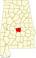
Mulberry, Autauga County, Alabama

Last updated

Mulberry, Alabama
USA Alabama location map.svg
Red pog.svg
Mulberry, Alabama
Usa edcp location map.svg
Red pog.svg
Mulberry, Alabama
Coordinates: 32°27′34″N86°46′35″W / 32.45944°N 86.77639°W / 32.45944; -86.77639
Country United States
State Alabama
County Autauga
Elevation
305 ft (93 m)
Time zone UTC-6 (Central (CST))
  Summer (DST) UTC-5 (CDT)
Area code 334
GNIS feature ID156759 [1]

Mulberry is an unincorporated community in Autauga County, Alabama, United States. [1] [2]

Emergency Services

Fire protection is provided by the Autaugaville Volunteer Fire Department.

Emergency Medical Services are provided by Haynes Ambulance.

Law enforcement agency is the Autauga County Sheriffs Office.

Notes

  1. 1 2 "Mulberry, Autauga County, Alabama". Geographic Names Information System . United States Geological Survey, United States Department of the Interior.
  2. Alabama Department of Transportation-Autauga County


Related Research Articles

<span class="mw-page-title-main">Autauga County, Alabama</span> County in Alabama, United States

Autauga County is a county located in the central portion of the U.S. state of Alabama. As of the 2020 census the population was 58,805. Its county seat is Prattville.

<span class="mw-page-title-main">Elmore County, Alabama</span> County in Alabama, United States

Elmore County is a county located in the east central portion of the U.S. state of Alabama. As of the 2020 census, the population was 87,977. Its county seat is Wetumpka. Its name is in honor of General John A. Elmore.

<span class="mw-page-title-main">Autaugaville, Alabama</span> Town in Alabama, United States

Autaugaville is a town in Autauga County, Alabama, United States. At the 2020 census, the population was 795. It is part of the Montgomery Metropolitan Statistical Area.

<span class="mw-page-title-main">Billingsley, Alabama</span> Village in Alabama, United States

Billingsley is a village in Autauga County, Alabama, United States. At the 2020 census, the population was 125. It is part of the Montgomery Metropolitan Statistical Area.

<span class="mw-page-title-main">Prattville, Alabama</span> City in Autauga and Elmore counties, Alabama, U.S.

Prattville is a city located within both Autauga and Elmore counties in the State of Alabama but serves as the county seat of Autauga County. As of the 2020 census, the population of the city was 37,781. Nicknamed "The Fountain City" due to the many artesian wells in the area, Prattville is part of the Montgomery metropolitan statistical area.

<span class="mw-page-title-main">Benjamin Fitzpatrick</span> Democratic governor of and U.S. Senator from Alabama

Benjamin Fitzpatrick was the 11th Governor of the U.S. state of Alabama and a United States Senator from that state. He was a Democrat.

Mulberry is the common name of several trees in the genus Morus. See the list of plants known as mulberry for plants with similar names.

<span class="mw-page-title-main">Prattville High School</span> Public school in Prattville, Alabama, United States

Prattville High School, formerly Autauga County High School, is a high school in Prattville, Alabama, United States. It forms part of the Autauga County School System. In 2010, it had an enrollment of 2,109 students and a faculty of 103 teachers in grades 9-12. In 2014, it had 2,057 students and 98 teachers. In 2018, there were 2,066 students, 101 teachers, and 5 administrators.

<span class="mw-page-title-main">Pine Level, Autauga County, Alabama</span> Place in Alabama, United States

Pine Level is a town and former census-designated place (CDP) in Autauga County, Alabama, north of Prattville and west of Deatsville. As of the 2010 census, the CDP's population was 4,183. The town is part of the Montgomery Metropolitan Statistical Area.

Booth is an unincorporated community in Autauga County, Alabama, United States. It was named after the Booth family. Booth lies along U.S. Route 82 8 mi (13 km) northwest of the city of Prattville, the county seat of Autauga County. US 82 also runs northwest 29 mi (47 km) to Maplesville. It has a post office that was established in 1899.

<span class="mw-page-title-main">Marbury, Alabama</span> Place in Alabama, United States

Marbury is an unincorporated community and census-designated place (CDP) in Autauga County, Alabama, United States. As of the 2010 census, its population was 1,418.

<span class="mw-page-title-main">Outline of Alabama</span> 22nd U.S. state, located in Southern U.S.

The following outline is provided as an overview of and topical guide to the U.S. state of Alabama:

Evergreen, also known as Huckabee, is an unincorporated community in Autauga County, Alabama.

Mulberry Creek is a 45.4-mile-long (73.1 km) waterway in central Alabama, United States. It rises in Chilton County and farther downstream forms the boundary between Dallas and Autauga counties. It is a tributary of the Alabama River.

Jones, originally Jones Switch, is an unincorporated community in Autauga County, Alabama, United States. The name was officially shortened on May 1, 1903. The community has a post office, with postmasters appointed from 1878 to 2006. The post office also serves unincorporated areas of Autauga County such as Vine Hill, Fremont, Bethel, Salem, Milton, and Fig Tree.

<span class="mw-page-title-main">National Register of Historic Places listings in Autauga County, Alabama</span>

This is a list of the National Register of Historic Places listings in Autauga County, Alabama.

Kingston, also known as Old Kingston, is an unincorporated community in Autauga County, Alabama. Kingston served as the county seat of Autauga County from 1830 to 1868, when it was moved to Prattville. Kingston became a ghost town, until a new community was formed around the home of Edmund Meredith Shackelford, an officer who served in the War of 1812. A post office was operated in Kingston from 1830 to 1908.

Washington is a ghost town located in Autauga County, Alabama on the north bank of the Alabama River, just west of the mouth of Autauga Creek. Washington was founded by European American settlers in 1817 on the site of the former Autauga Indian town of Atagi and named in honor of George Washington. On November 22, 1819, the Alabama territorial legislature chose Washington as the county seat of Autauga County, which it remained until 1830. A courthouse, hotel, jail, post office and pillory were constructed to meet the needs of the county government.

<span class="mw-page-title-main">Alabama State Route 111</span> Highway in Alabama

State Route 111 (SR 111) is a 16.073-mile-long (25.867 km) state highway in Elmore and Autauga counties in the central part of the U.S. state of Alabama. The southern terminus of the highway is at an intersection with SR 212 in Wetumpka. The northern terminus of the highway is at an intersection with SR 143 west of Coosa River.

Autauga Academy is a private coed PK-12 school in Prattville, Alabama, the seat of Autauga County.