Coffee County is a county located in the southeastern part of the U.S. state of Alabama. As of the 2020 census, the population was 53,465. Its name is in honor of General John Coffee.

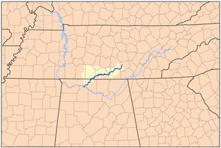
The Elk River is a tributary of the Tennessee River in the U.S. states of Tennessee and Alabama. The river is about 195 miles (314 km) long.
Damascus is an unincorporated community in Coffee County, Alabama, United States.
Pine Level is an unincorporated community in Coffee County, Alabama, United States. Pine Level is located on Alabama State Route 141, 8.2 miles (13.2 km) northwest of Elba.
Danleys Crossroads is an unincorporated community in Coffee County, Alabama, United States. Danleys Crossroads is located at the junction of Alabama State Routes 141 and 166, 5.9 miles (9.5 km) west of Elba.
Basin is an unincorporated community in Coffee County, Alabama, United States. Basin is located along Alabama State Route 189, 6.2 miles (10.0 km) southwest of Elba.
Curtis is an unincorporated community in Coffee County, Alabama, United States. Curtis is located at the junction of U.S. Route 84 and Alabama State Route 141, 5.4 miles (8.7 km) west-southwest of Elba.
Ino is an unincorporated community in Coffee County, Alabama, United States.
Alberton is an unincorporated community in Coffee County, Alabama, United States. Alberton is located along Alabama State Route 134, 9.7 miles (15.6 km) south-southwest of Elba.
Battens Crossroads, also known as Union Academy, is an unincorporated community in Coffee County, Alabama, United States. Battens Crossroads is located along Alabama State Route 27, 13.9 miles (22.4 km) southeast of Elba.
Central City, also known as Eta, is an unincorporated community in Coffee County, Alabama, United States. Central City is located along Alabama State Route 27, 5.2 miles (8.4 km) south-southwest of Enterprise.
Clintonville, also known as Indigo Head, is an unincorporated community in Coffee County, Alabama, United States. Clintonville is located at the junction of Alabama State Route 51 and Alabama State Route 122, 2.5 miles (4.0 km) northeast of New Brockton.
Damascus is an unincorporated community in Coffee County, Alabama, United States.
Frisco, also spelled Fresco, is an unincorporated community in Coffee County, Alabama, United States.
Java is an unincorporated community in Coffee County, Alabama, United States.
Keyton is an unincorporated community in Coffee County, Alabama, United States. Keyton is located along Alabama State Route 167, 2.4 miles (3.9 km) southeast of downtown Enterprise. Most of Keyton lies within the Enterprise city limits.
Richburg is an unincorporated community in Coffee County, Alabama, United States. Richburg is located along U.S. Route 84, 2.0 miles (3.2 km) west-northwest of New Brockton.
Tabernacle, also spelled Tabanacle, is an unincorporated community in Coffee County, Alabama, United States. Tabernacle is located along Alabama State Route 51, 5.7 miles (9.2 km) north-northwest of New Brockton.
Victoria, also known as Smut Eye or Buzbeeville, is an unincorporated community in Coffee County, Alabama, United States. Victoria is located along Alabama State Route 125, 10.8 miles (17.4 km) northeast of Elba.


