
Clarke County is a county located in the southwestern part of the U.S. state of Alabama. As of the 2010 census, the population was 25,833. The county seat is Grove Hill. The county was created by the legislature of the Mississippi Territory in 1812. It is named in honor of General John Clarke of Georgia, who was later elected governor of that state.

Colbert County is a county located in the northwestern part of the U.S. state of Alabama. As of the 2010 census the county's population was 54,428. The county seat is Tuscumbia. Its name is in honor of brothers George and Levi Colbert, Chickasaw Indian chiefs.

Sheboygan County is a county in the U.S. state of Wisconsin. It is named after the Sheboygan River. As of the 2010 census, the population was 115,507. Its county seat is Sheboygan. The county was created in 1836 and organized in 1846. At the time, it was located in the Wisconsin Territory.

Cheatham County is a county located in the U.S. state of Tennessee. As of the 2010 census, the population was 39,105. Its county seat is Ashland City.

McKinley County is a county in the northwestern section of the U.S. state of New Mexico. As of the 2010 census, the population was 71,492. Its county seat is Gallup. The county was created in 1901 and named for President William McKinley.
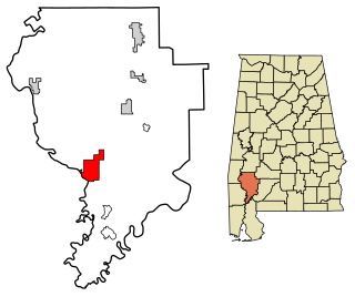
Jackson is a city in Clarke County, Alabama, United States. The population was 5,228 at the 2010 census. It was one of three wet settlements in an otherwise-dry county.

Geneva is a city in and the county seat of Geneva County, Alabama, United States. It was incorporated in 1875. It is part of the Dothan, Alabama Metropolitan Statistical Area. Since 1940, it has been the largest city of Geneva County, and had a population of 4,452 as of the 2010 census.

Akron is a town in Hale County, Alabama, United States. In 1906, the owner of a large plantation, Waller Evan Wedgworth, sold part of his land to developers, and a construction boom followed. The town was incorporated in March 1918. At the 2010 census the population was 356, down from 521 at the 2000 census. Akron has one site on the National Register of Historic Places, the Greek Revival cottage known as Tanglewood.
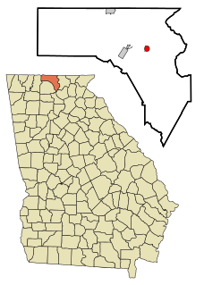
Morganton is a city in Fannin County, Georgia, United States. The population was 303 at the 2010 census.

Indian Head Park is a village in Cook County, Illinois, United States, slightly north of the intersection of Interstate 294 and Interstate 55. The village is south of Western Springs, west of Countryside, north and east of Burr Ridge. The population was 3,809 at the 2010 census. The village's ZIP code is 60525.

Elnora is a town in Elmore Township, Daviess County, Indiana, United States. The population was 640 at the 2010 census.

Blue Diamond is a census-designated place (CDP) in Clark County, Nevada, United States. The population was 290 at the 2010 census.

Lafayette Township is a township in McKean County, Pennsylvania, United States.

Union Township is in Schuylkill County, Pennsylvania, United States. The population was 1,308 at the 2000 census.
Clymer Township is a township in Tioga County, Pennsylvania, in the United States. The population was 581 at the 2010 census.

Pittsfield Township is a township in Warren County, Pennsylvania, United States. The population was 1,519 at the 2000 census.

Jackson Township is a township in York County, Pennsylvania, United States. The population was 7,494 at the 2010 census. It was founded in 1853 from parts of Paradise Township. Jackson Township education is served by the Spring Grove Area School District and Police Coverage by Northern York County Regional Police Department

St. Francis is a city in Milwaukee County, Wisconsin, United States. The population was 9,365 at the 2010 census.
Davidson is an unorganized territory in Polk County, Minnesota, United States. The population was 42 at the 2010 census.

In the geologic timescale, the Roadian is an age or stage of the Permian. It is the earliest or lower of three subdivisions of the Guadalupian epoch or series. The Roadian lasted between 272.95 and 268.8 million years ago (Ma). It was preceded by the Kungurian and followed by the Wordian.


