
Clarke County is a county located in the southwestern part of the U.S. state of Alabama. As of the 2010 census, the population was 25,833. The county seat is Grove Hill. The county was created by the legislature of the Mississippi Territory in 1812. It is named in honor of General John Clarke of Georgia, who was later elected governor of that state.

Bay Minette is a city in Baldwin County, Alabama. As of the 2010 census, the population of the city was 8,044. The city is the county seat of Baldwin County.
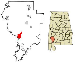
Jackson is a city in Clarke County, Alabama, United States. The population was 5,228 at the 2010 census. It was one of three wet settlements in an otherwise-dry county.

Thomasville is a city in Clarke County, Alabama, United States. At the 2010 census the population was 4,209. Founded as a late 19th-century railroad town, it has transitioned over the course of more than a century into a 21st-century commercial hub. It is the childhood hometown of author and storyteller Kathryn Tucker Windham.

Whatley is a census-designated place in Clarke County, Alabama, United States. As of the 2010 census, its population was 225. It is named in honor of Franklin Benjamin Whatley. It has one site on the National Register of Historic Places, the Whatley Historic District.

Ash Grove Township is one of twenty-six townships in Iroquois County, Illinois, USA. As of the 2010 census, its population was 731 and it contained 316 housing units.

Campbell is an unincorporated community in Clarke County, Alabama, United States.
Coastal Alabama Community College is a public community college with nine campuses in southern Alabama: Bay Minette, Fairhope, Gulf Shores, Atmore, Brewton, Gilbertown, Jackson, Monroeville, and Thomasville. It is a member of the Alabama Community College System. Coastal Alabama was formed through the consolidation of Alabama Southern Community College, Faulkner State Community College, and Jefferson Davis Community College.

Carlton is an census-designated place in Clarke County, Alabama, United States. As of the 2010 census, its population was 65. It was formerly known as Hal's Lake. The Isaac Nettles Gravestones are located in Carlton in the Mount Nebo Baptist Church Cemetery. They are listed on the National Register of Historic Places.
Alma is an unincorporated community in Clarke County, Alabama, United States. The community was named for Alma Flinn, a local teacher.
Dickinson is an unincorporated community in Clarke County, Alabama, United States. Dickinson is the hometown of Tom Franklin, a crime fiction writer. Dickinson also has the highest percentage of Cubans in the state.

Gainestown is an unincorporated community on the Alabama River in Clarke County, Alabama, United States. It was named for George Strother Gaines, who was the senior United States Indian agent in the region; he established a trading post here in 1809 for business with the Choctaw, the predominant tribe.

Arlington, originally known as Dumas Store, is an unincorporated community in Wilcox County, Alabama, United States.
Buena Vista is an unincorporated community in Monroe County, Alabama. The village of Buena Vista is listed on the Alabama Register of Landmarks and Heritage. Additionally, it has one other site listed, the Concord Baptist Church.
Etherly was a town located in Knox County, Illinois, south of Victoria.

Suggsville is an unincorporated community in Clarke County, Alabama. It was laid out as a town in 1819 at the crossing of the Old Line Road and Federal Road. The name was chosen in honor of a local storekeeper, William Suggs. The first newspaper in Clarke County was published here, the Clarke County Post. The town had many residences, stores, and male and female academies prior to the American Civil War, but declined rapidly in the post-war period.
Tallahatta Springs, once called Lowder Springs, is an unincorporated community in Clarke County, Alabama, United States. It was once known for its mineral springs at the headwaters of Tallahatta Creek. A health resort was established here in the middle of the 19th century. Language scholars believe Tallahatta to be an adaptation of two Choctaw language words: tali (rock) and hata (silver/white), literally "white rock."
Bashi is an unincorporated community in Clarke County, Alabama, United States. It takes its name from the nearby Bashi Creek that flows westward into the Tombigbee River.
The Choctaw Corner is a former Native American boundary location near the modern border between Clarke and Marengo counties in Alabama, United States. It was established as the northernmost terminus for a mutually agreed upon boundary line between the Choctaw and Creek peoples during the Mississippi Territory period. This boundary line, now known as the “Old Indian Treaty Boundary,” starts at the Alabama River cut-off in southernmost Clarke County and follows a northward path through the county along the drainage divide between the Tombigbee and Alabama rivers to the Choctaw Corner, then turns ninety degrees to the west and follows the modern county-line between Clarke and Marengo to the Tombigbee River.
Choctaw Corner was a former town in Clarke County, Alabama, United States. It is named for the nearby Choctaw Corner, which marked the border between the native Choctaw and Creek peoples prior to the Indian removal. The community was one of the earliest settlements in the county.


