Poulan is a city in Worth County, Georgia, United States. The population was 851 at the 2010 and 765 (2019) census.

Iron Gate is a town in eastern Alleghany County, Virginia, United States. The population was 324 at the 2020 census. The town is located along U.S. Route 220, near Clifton Forge.
Jacobs is a neighborhood on the south side of Louisville, Kentucky, in the United States. Its boundaries are Berry Boulevard to the north, Taylor Boulevard to the east, the I-264 to the south, and Seventh Street to the west. It was developed as Jacob's Addition in 1892 after the opening of nearby Jacob's Park and named for four-time Louisville mayor Charles Donald Jacob. The area housed a veteran's hospital, Nichols General Hospital, until 1952. The area includes Manslick Cemetery, a burial ground for indigents started in the 1870s, and Watterson Lake Park.

Kibaale is a town in the Western Region of Uganda. It is the main municipal, administrative, and commercial center of Kibaale District, and the district headquarters are located there.
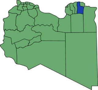
Quba or Qoba was one of the 32 districts of Libya. In 2007 it became part of the Derna District. The population of the former district was approximately 93,000.

The Campanha Ocidental micro-region is a microregion in the western part of the state of Rio Grande do Sul, Brazil. The area is 31,125.429 km² making it the largest micro-region in the state nearly covering one-tenth of the entire state, much of the central and eastern portions remain underpopulated.

Skiff is a hamlet in southern Alberta, Canada within the County of Forty Mile No. 8. It is located on Highway 61, also known as the historic Red Coat Trail, approximately 75 km (47 mi) southeast of Lethbridge.
Hopkins is an unincorporated community in Accomack County, Virginia, United States.

Cuatro Vientos is an administrative neighborhood of Madrid belonging to the district of Latina.
Stoczki is a village in the administrative district of Gmina Sieradz, within Sieradz County, Łódź Voivodeship, in central Poland. It lies approximately 10 kilometres (6 mi) south of Sieradz and 56 km (35 mi) south-west of the regional capital Łódź.
Giże is a village in the administrative district of Gmina Ełk, within Ełk County, Warmian-Masurian Voivodeship, in northern Poland.

The following timeline traces the territorial evolution of the U.S. State of Arizona.

The Bay of Tangier is a bay around Tangier on the Mediterranean in northern Morocco. It forms the body of water between the port and Cap Malabata in a semi circular shape. Avenue d'Espagne runs along the bay and is known for its hotels and large modern establishments.
Gornja Crnča is a village in the municipality of Višegrad, Bosnia and Herzegovina.

Klondyke is an unincorporated community in southern Reserve Township, Parke County, in the U.S. state of Indiana.
Stage Junction is an unincorporated community in Fluvanna County, in the U.S. state of Virginia.

Gila Community College (GCC) is the community college serving the Gila Community College District in Gila County, Arizona. It has three campuses:
- Gila Pueblo Campus, Globe, Arizona
- Payson Campus, Payson, Arizona
- San Carlos Campus, San Carlos, Arizona
Yancy Mills is an unincorporated community in Phelps County, Missouri, United States.