
Clarke County is a county located in the southwestern part of the U.S. state of Alabama. As of the 2020 census, the population was 23,087. The county seat is Grove Hill. The county's largest city is Jackson. The county was created by the legislature of the Mississippi Territory in 1812. It is named in honor of General John Clarke of Georgia, who was later elected governor of that state.

Lowndesboro is a town in Lowndes County, Alabama, United States. At the 2010 census the population was 115, down from 140 in 2000. It is part of the Montgomery Metropolitan Statistical Area. Although initially incorporated in 1856 by an act of the state legislature, it lapsed and was not reincorporated until 1962.
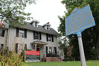
Claymont is a census-designated place (CDP) in New Castle County, Delaware. The estimated 2017 population of the 19703 ZIP code, which Claymont encompasses, was 15,292.

Pinopolis is an unincorporated community and census-designated place in Berkeley County, South Carolina, United States. As of the 2010 census it had a population of 948.

Millwood is an unincorporated community located in Clarke County, Virginia, United States. Millwood is the home of many of Clarke County's most historic sites including the Burwell-Morgan Mill (1785), Carter Hall (1792), the Greenway Historic District, Long Branch (1811), Old Chapel (1790), and the River House. Project HOPE is based at Carter Hall.

Letohatchee is an unincorporated community in Lowndes County, Alabama, United States. It has a very small population and four businesses. The community is part of the Montgomery Metropolitan Statistical Area.

Seale is an unincorporated community in Russell County, Alabama, United States. It was the county seat from 1868 until 1935, and is currently home to Russell County High School and middle school. The former Russell County courthouse, built in 1868, is located in the town.

Verbena, also known as Summerfield, is an unincorporated community in southeastern Chilton County, Alabama, United States. Named for the indigenous flower, Verbena developed into a popular resort location for the more affluent citizenry of Montgomery, the state's capital, during the yellow fever outbreaks of the late 19th and early 20th centuries. Many stately homes, some of which have undergone recent renovation and restoration, line the streets of the town as a reminder of this historic past.
Hollister is a census-designated place and unincorporated community in Halifax County in northeastern North Carolina, United States. As of the 2010 census it had a population of 674. Hollister's ZIP code is 27844.
Nathalie is an unincorporated community and census-designated place (CDP) in Halifax County, Virginia, United States, in the south-central region of the state. The population as of the 2010 census was 183.

Painesdale is an unincorporated community in Houghton County, Michigan, United States. Painesdale is located in Adams Township along M-26, 2.5 miles (4.0 km) southwest of South Range. Painesdale has a post office with ZIP code 49955.
Hatchechubbee is an unincorporated community in Russell County, Alabama, United States. Hatchechubbee is located at the junction of Alabama State Route 26 and County Route 65, 6.5 miles (10.5 km) west-southwest of Seale. Hatchechubbee has a post office with ZIP code 36858, which opened on August 17, 1855. The community's name is derived from the Creek words hachi meaning "creek" and chaba meaning "halfway".
Houston is an unincorporated community in Winston County, Alabama, United States. It was the county seat from 1858 until 1884, when the seat was moved to Double Springs. Houston has one site on the National Register of Historic Places, the log Houston Jail.
Townley is an unincorporated community in Walker County, Alabama, United States. It was formerly an incorporated town from 1895 until the 1920s. Townley has one site on the National Register of Historic Places, Boshell's Mill.

Adams Run is an unincorporated community and census-designated place (CDP) in Charleston County, South Carolina, United States. It was first listed as a CDP in the 2020 census with a population of 421.
Clopton is an unincorporated community and census-designated place (CDP) in Dale County, Alabama, United States. Clopton is located on Alabama State Route 105, 10.9 miles (17.5 km) west-northwest of Abbeville.
Skipperville is an unincorporated community in Dale County, Alabama, United States. Skipperville is located on Alabama State Route 105, 8.8 miles (14.2 km) northeast of Ozark. Skipperville has a post office with ZIP code 36374, which opened on November 10, 1853.This community also consists of G.W. Long School, which has won a 2a state championship for baseball in many previous years. This school also has other sports teams with state wide victories.
Abernant is an unincorporated community in Tuscaloosa County, Alabama, United States. Abernant is located along Alabama State Route 216, 3.6 miles (5.8 km) west of Lake View. Abernant has a post office with ZIP code 35440.
Alton is an unincorporated community in Jefferson County, Alabama, United States. Alton is located along Interstate 459, 10 miles (16 km) east-northeast of downtown Birmingham. Alton has a post office with ZIP code 35015. Part of the community has been annexed into the city of Birmingham, while the remainder remains an unincorporated area surrounded by the city.

South Mills is an unincorporated community and census-designated place (CDP) in Camden County, North Carolina, United States. Its population was 454 as of the 2010 census. South Mills has a post office with ZIP code 27976, which opened on March 2, 1840. The community is located near U.S. Route 17, and U.S. Route 17 Business and North Carolina Highway 343, and future Interstate 87 pass through the community.

