
Escambia County is the westernmost and oldest county in the U.S. state of Florida, located in the northwestern corner of the state. At the 2010 census, the population is 297,619. Its county seat and largest city is Pensacola.

Okaloosa County is located in the northwestern portion of the U.S. state of Florida, extending from the Gulf of Mexico to the Alabama state line. As of the 2010 census, the population was 180,822. Its county seat is Crestview.

Baldwin County is a county located in the southwestern part of the U.S. state of Alabama, on the Gulf coast. According to the 2019 estimates from the U.S. Census Bureau, the population is approximately 223,234. The county seat is Bay Minette. The county is named in honor of Senator Abraham Baldwin, though he never lived in what is now Alabama.

Escambia County is a county located in the south central portion of the U.S. state of Alabama. As of the 2010 census, the population was 38,319. Its county seat is Brewton.

Atmore is a city in Escambia County, Alabama, United States. It incorporated in 1907. As of the 2010 census it had a population of 10,194, with an estimated population of 9,107 in 2019. Atmore is in the planning stages to increase its economic base with additions in its new Rivercane development along the I-65 corridor.

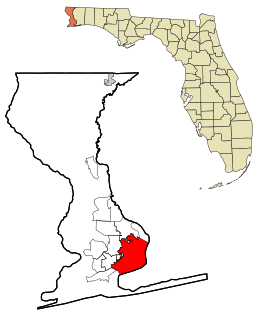
Brewton is a city in Escambia County, Alabama, United States. At the 2010 census, the population was 5,408. The city is the county seat of Escambia County. Brewton is located in south central Alabama, just north of the Florida Panhandle.

East Brewton is a city in Escambia County, Alabama, United States. It was incorporated in October 1918. At the 2010 census the population was 2,478. The community grew around Fort Crawford, a fort built to protect early settlers of the area.

Flomaton is a town in Escambia County, Alabama, United States. At the 2010 census the town's population was 1,440. It is located next to the Alabama / Florida state line.

Century is a town in Escambia County, Florida, United States. The population was 1,698 at the 2010 United States Census. It is part of the Pensacola–Ferry Pass–Brent Metropolitan Statistical Area.
Pensacola is the westernmost city in the Florida Panhandle, and the county seat of Escambia County, Florida. As of 2019, the population was estimated to be 52,975. Pensacola is the principal city of the Pensacola Metropolitan Area, which had an estimated 502,629 residents as of 2019. Pensacola is one of the largest metropolitan areas in the Gulf Coast region, the largest between New Orleans and Tampa.

The Florida Panhandle is the northwestern part of the U.S. state of Florida; it is a strip of land roughly 200 miles (320 km) long and 50 to 100 miles wide, lying between Alabama on the north and the west, Georgia on the north, and the Gulf of Mexico to the south. Its eastern boundary is arbitrarily defined. Major communities include Tallahassee, Pensacola, and Navarre; in terms of population.

Alabama's 1st congressional district is a United States congressional district in Alabama, which elects a representative to the United States House of Representatives. It includes the entirety of Washington, Mobile, Baldwin, Escambia and Monroe counties, and also includes part of Clarke County. The largest city in the district is Mobile.

The Conecuh River and Escambia River constitute a single 258-mile-long (415 km) river in Alabama and Florida in the United States.
The Poarch Creek Indian Reservation is a Creek Indian reservation in the state of Alabama. It is the home of the Poarch Band of Creek Indians, the only federally recognized Native American tribe in the state.

The Escambia map turtle is a species of turtle in the family Emydidae. The species is endemic to the United States.

Carpenter's Station, Alabama, is a community located in Baldwin County, Alabama. It appears as "Carpenter" on the Bay Minette South U.S. Geological Survey Map.
Nokomis is an unincorporated community in Escambia County, Alabama, United States. Nokomis is located along U.S. Route 31 and a CSX Transportation line 4.3 miles (6.9 km) west-southwest of Atmore. Nokomis has the distinction of having boundaries in three U.S. counties: Escambia, Alabama; Escambia, Florida; and Baldwin, Alabama.
Foshee is an unincorporated community in Escambia County, Alabama, United States between Brewton and Pollard on U.S. Route 29. Foshee was founded as a sawmill town and named after Stewart J. Foshee, who owned several sawmills in Escambia County. Russell A. Alger and Martin Sullivan founded the Alger-Sullivan Lumber Company in the late 1890s and began logging around Foshee. They used lumber from the mill to build a new sawmill in Florida, which eventually grew into the town of Century. A post office was operated in Foshee from 1914 to 1924.
Orion, also known as Prospect Ridge, is an unincorporated community in Pike County, Alabama, United States, located 12.9 miles (20.8 km) north of Troy.

Millview is an unincorporated community located along Perdido Bay in Escambia County, Florida, United States.


