Dixonville, Alabama | |
---|---|
Coordinates: 31°00′02″N87°02′10″W / 31.00056°N 87.03611°W Coordinates: 31°00′02″N87°02′10″W / 31.00056°N 87.03611°W | |
Country | United States |
State | Alabama |
County | Escambia |
Elevation | 282 ft (86 m) |
Time zone | UTC-6 (Central (CST)) |
• Summer (DST) | UTC-5 (CDT) |
Area code(s) | 251 |
GNIS feature ID | 117321 [1] |
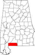
Dixonville is a small unincorporated community in Escambia County, Alabama, United States, on the Florida border. The community name continues south of the border as Dixonville, Florida.
Santa Rosa County is a county located in the northwestern portion of the U.S. state of Florida. As of the 2010 Census, the population was 151,372. The county seat is Milton, which lies in the geographic center of the county. Other major communities within Santa Rosa County are Navarre, Pace, and Gulf Breeze.
Escambia County is a county located in the south central portion of the U.S. state of Alabama. As of the 2010 census, the population was 38,319. Its county seat is Brewton.
Cheval is an unincorporated census-designated place in Hillsborough County, Florida, United States. The population was 10,702 at the 2010 census, up from 7,602 at the 2000 census.
Lutz is an unincorporated census-designated place (CDP) in Hillsborough County, Florida, United States. It is fifteen miles north of Tampa. The northern part of Lutz also makes up a portion of south Pasco County. The population was 19,344 at the 2010 census.
Dixonville is an unincorporated community in Indiana County, Pennsylvania, United States. The area is recorded as the "Dicksonville" census-designated place (CDP), with a population of 467 at the 2010 census. The CDP lies mostly on the western edge of Green Township, though a small portion extends west into Rayne Township.
Warwick is a town in the southwestern part of Orange County, New York, United States. Its population was 32,065 at the 2010 census. The town contains three villages and eight hamlets.
A census-designated place (CDP) is a concentration of population defined by the United States Census Bureau for statistical purposes only. CDPs have been used in each decennial census since 1980 as the counterparts of incorporated places, such as self-governing cities, towns, and villages, for the purposes of gathering and correlating statistical data. CDPs are populated areas that generally include one officially designated but currently unincorporated community, for which the CDP is named, plus surrounding inhabited countryside of varying dimensions and, occasionally, other, smaller unincorporated communities as well. CDPs include small rural communities, colonias located along the Mexico–United States border, and unincorporated resort and retirement communities and their environs.
The Florida Parishes, on the east side of Mississippi River – an area also known as the Northshore or Northlake region – are eight parishes in southeast Louisiana, United States, which were part of West Florida in the 18th and early 19th centuries. Unlike most of the state, this region was not part of the 1803 Louisiana Purchase; it had been under British and then Spanish control since 1763.
Deadwood is a hamlet in Alberta, Canada within the County of Northern Lights. It is located on Highway 690, approximately 10 kilometres (6.2 mi) east of the Mackenzie Highway, 80 kilometres (50 mi) north of Peace River and 34 kilometres (21 mi) southeast of Manning.
Balm is an unincorporated census-designated place in Hillsborough County, Florida, United States. The population was 1,457 at the 2010 census.
Lealman, known as East Lealman until 2010, is a census-designated place (CDP) in Pinellas County, Florida, United States. The population was 19,879 at the 2010 census. Prior to 2010, Lealman was part of a larger CDP named West and East Lealman.
State Route 41 (SR 41) is a 127.484-mile-long (205.166 km) state highway in the southwestern part of the U.S. state of Alabama. The southern terminus of the highway is at the Florida state line near Dixonville in Escambia County, where the roadway continues as Florida State Road 87. The northern terminus of the highway is at its intersection with SR 14 at Selma.
Dixonville is a hamlet in Alberta, Canada within the County of Northern Lights. It is located along the Mackenzie Highway, approximately 43 kilometres (27 mi) north of Grimshaw. It has an elevation of 640 metres (2,100 ft).
West Lealman is a census-designated place (CDP) in Pinellas County, Florida, United States. The population was 15,651 at the 2010 census. Prior to 2010, West Lealman was part of a larger CDP named West and East Lealman.
Oxford is an unincorporated community in Sumter County, Florida, United States. Its ZIP code is 34484.
Fairvilla is an unincorporated community in Orange County, Florida, United States. The community is located along U.S. Route 441 along the northern border of Orlando, and parts of it have been annexed by the city. The area is known as a commercial district and includes the Fairvilla Adult Superstore sex shop. During the 1980s, an urban legend began regarding a large red apeman known as the "Fairvilla Gorilla", which had supposedly been sighted in the area.
Dixonville is an unincorporated community and census-designated place in Santa Rosa County, Florida, United States. Its population was 181 as of the 2010 census. Florida State Road 87 passes through the community. The community name continues north of the state line in Alabama along Alabama State Route 41.
Floridatown is an unincorporated community and census-designated place located in Santa Rosa County, Florida. It is now considered to be a neighborhood within Pace. Its population was 244 as of the 2010 census.
Dixonville is a former unincorporated community in Guthrie Township, Lawrence County, Indiana.
This Escambia County, Alabama state location article is a stub. You can help Wikipedia by expanding it. |