Troyville Earthworks

Last updated
Troyville Earthworks
(16 CT 7)
Troyville Earthworks HRoe 2017sm.jpg
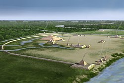
Artists conception of Troyville Earthworks
USA Louisiana location map.svg
Archaeological site icon (red).svg
Location within Louisiana today
Location Catahoula Parish, Louisiana,  United States
RegionCatahoula Parish, Louisiana
Coordinates 31°37′36.59″N91°48′56.12″W / 31.6268306°N 91.8155889°W / 31.6268306; -91.8155889
History
Founded100 BCE
Abandoned1100 CE
Cultures Baytown culture, Troyville culture-Coles Creek culture
Site notes
Excavation dates1931-1932,
Archaeologists Winslow Walker
Architecture
Architectural styles platform mounds, plaza
Responsible body: private

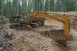
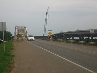
Troyville Earthworks (16 CT 7) is a Woodland period Native American archaeological site with components dating from 100 BCE to 700 CE during the Baytown to the Troyville-Coles Creek periods. It once had the tallest mound in Louisiana at 82 feet (25 m) in height. It is located in Catahoula Parish, Louisiana in the town of Jonesville. [1] The site is the type site for the Troyville culture of the lower Ouachita and Tensas River valleys. [2] Before it was destroyed for bridge approach fill in 1931, the main mound at Troyville was one of the tallest in North America.

Smithsonian trinomials are unique identifiers assigned to archaeological sites in many states in the United States. They are composed of one or two digits coding for the state, typically two letters coding for the county or county-equivalent within the state, and one or more sequential digits representing the order in which the site was listed in that county. The Smithsonian Institution developed the site number system in the 1930s and 1940s. The 48 states then in the union were assigned numbers in alphabetical order. Alaska was assigned number 49 and Hawaii was assigned number 50 after those states were admitted to the union. There are no Smithsonian trinomial numbers assigned for the District of Columbia or any United States territories.

Woodland period period of North American pre-Columbian cultures

In the classification of Archaeological cultures of North America, the Woodland period of North American pre-Columbian cultures spanned a period from roughly 1000 BCE to European contact in the eastern part of North America, with some archaeologists distinguishing the Mississippian period, from 1000 CE to European contact as a separate period. The term "Woodland Period" was introduced in the 1930s as a generic term for prehistoric sites falling between the Archaic hunter-gatherers and the agriculturalist Mississippian cultures. The Eastern Woodlands cultural region covers what is now eastern Canada south of the Subarctic region, the Eastern United States, along to the Gulf of Mexico.

Native Americans in the United States Indigenous peoples of the United States (except Hawaii)

Native Americans, also known as American Indians, Indigenous Americans and other terms, are the indigenous peoples of the United States, except Hawaii. There are over 500 federally recognized tribes within the US, about half of which are associated with Indian reservations. The term "American Indian" excludes Native Hawaiians and some Alaska Natives, while Native Americans are American Indians, plus Alaska Natives of all ethnicities. Native Hawaiians are not counted as Native Americans by the US Census, instead being included in the Census grouping of "Native Hawaiian and other Pacific Islander".

Contents

Site description

Layout of the site Troyville Earthworks layout Troyville culture HRoe 2011.jpg
Layout of the site

The site is at the confluence of the Tensas, Ouachita, and Little Rivers. It had nine platform mounds and a perimeter embankment that were built before 700 CE. A historian, John W. Monette, in 1844 described the complex as occupying close to 400 acres and noted the existence of twelve small mounds and one large one. [3] The embankment was started during the Middle Baytown period, with periodic repair work taking place during the Late Baytown period. [4] The largest mound, Mound 5 ( also known as the "Great Mound" ), was 82 feet (25 m) in height. [1] It was the tallest precolumbian mound in Louisiana and the second tallest in North America. Its base covered an acre of ground [5] and had three levels, the bottom two rectangular and the third on the top a truncated conical mound. [6] Monette described the lower level of Mound 5 as being 300 feet (91 m) by 150 feet (46 m) at its base and rising to the height of 30 feet (9.1 m). He described the conical mound at the top as 30 feet (9.1 m). [3] Measurements for the smaller mounds at the site were about 12 feet (3.7 m) to 20 feet (6.1 m) in height with bases measuring 150 feet (46 m) by 60 feet (18 m). Four of the mounds were surrounded on the southern and western side of the plaza by the embankment, which measured 10 feet (3.0 m) in height, 10 feet (3.0 m) in width and 100 feet (30 m) across. [5]

Tensas River river in the United States of America

The Tensas River is a river in Louisiana in the United States. The river, known as Tensas Bayou in its upper reaches, begins in East Carroll Parish in the northeast corner of the state and runs roughly southwest for 177 miles (285 km) more or less in parallel with the Mississippi River. The Tensas River merges with the Ouachita River in Jonesville in Catahoula Parish to become the Black River, not to be confused with Black Lake in Natchitoches Parish in north central Louisiana.

Ouachita River river in the United States of America

The Ouachita River is a 605-mile-long (974 km) river that runs south and east through the U.S. states of Arkansas and Louisiana, joining the Tensas River to form the Black River near Jonesville, Louisiana. It is the 25th-longest river in the United States.

The Little River is a 96-mile-long (154 km) tributary of the Ouachita (Black) River in central Louisiana in the United States. Via the Ouachita and Red rivers, it is part of the watershed of the Mississippi River. According to the Geographic Names Information System, the Little River has also been known historically as "Bayou Des Nacitoches," "Catahoula Bayou," and "Catahoula River."

By the time of the American Civil War, the mound had been reduced in size to 50 feet (15 m) in height. [1] During the Civil War, the mound was reduced even further when some of its fill was removed to construct Confederate rifle pits. In 1871 the town of Jonesville was founded on the site and more of Mound A's fill was used to fill ditches (borrow pits created by the removal of earth to construct the mounds themselves) and level the land as the town grew. The townspeople frequently camped out on the mounds during flooding. [7]

American Civil War Civil war in the United States from 1861 to 1865

The American Civil War was a war fought in the United States from 1861 to 1865, between the North and the South. The Civil War is the most studied and written about episode in U.S. history. Primarily as a result of the long-standing controversy over the enslavement of black people, war broke out in April 1861 when secessionist forces attacked Fort Sumter in South Carolina shortly after Abraham Lincoln had been inaugurated as the President of the United States. The loyalists of the Union in the North proclaimed support for the Constitution. They faced secessionists of the Confederate States in the South, who advocated for states' rights to uphold slavery.

Confederate States of America (de facto) federal republic in North America from 1861 to 1865

The Confederate States of America, commonly referred to as the Confederacy and the South, was an unrecognized country in North America that existed from 1861 to 1865. The Confederacy was originally formed by seven secessionist slave-holding states—South Carolina, Mississippi, Florida, Alabama, Georgia, Louisiana, and Texas—in the Lower South region of the United States, whose economy was heavily dependent upon agriculture, particularly cotton, and a plantation system that relied upon the labor of African-American slaves.

Borrow pit

In construction and civil engineering, a borrow pit, also known as a sand box, is an area where material has been dug for use at another location. Borrow pits can be found close to many major construction projects. For example, soil might be excavated to fill an embankment for a highway, clay might be excavated for use in brick-making, gravel to be used for making concrete, etc.

In 1883 the site was visited by the prominent ethnologist Cyrus Thomas, who described the group as then consisting of six mounds within an embankment, with some of the smaller mounds having been largely destroyed. One had been turned into a modern cemetery, which can still be seen today on the grounds of the local Methodist Church. The Great Mound had also been reduced, by this time it was only 45 feet (14 m) in height, 270 feet (82 m) in length and 180 feet (55 m) in width. [8] In 1931 the mound was drastically reduced in size, the majority of its remaining mass being used as fill for a nearby bridge approach. [1] Today the mound is only 3 feet (0.91 m) in height.

Cyrus Thomas American Mesoamericanist and entomologist

Cyrus Thomas was a U.S. ethnologist and entomologist prominent in the late 19th century and noted for his studies of the natural history of the American West.

Excavations

Different heights and profiles of Mound 5 Great Mound Troyville Earthworks HRoe 2011.jpg
Different heights and profiles of Mound 5

The site takes its name from the Troy Plantation, which was part of a Spanish land grant of 1,000 acres made to John Hebrard in 1786. [7] William Dunbar was the first European to make note of the mound site in his report to Thomas Jefferson for the Red River expedition of 1804. It is the first written description of an archaeological site in Louisiana. [4]

William Dunbar (explorer) American explorer

William Dunbar (1750–1810) was a Scottish and American merchant, plantation owner, naturalist, astronomer and explorer.

Thomas Jefferson 3rd president of the United States

Thomas Jefferson was an American statesman, diplomat, lawyer, architect, and Founding Father who served as the third president of the United States from 1801 to 1809. Previously, he had served as the second vice president of the United States from 1797 to 1801. The principal author of the Declaration of Independence, Jefferson was a proponent of democracy, republicanism, and individual rights motivating American colonists to break from the Kingdom of Great Britain and form a new nation; he produced formative documents and decisions at both the state and national level.

In 1931 and 1932 the Smithsonian archaeologist Winslow Walker excavated parts of the site. He found woven cane matting, palmetto fronds, and wooden planks within the mound, materials used by the Native Americans as part of the complex engineering to build the large structure. [1] These materials had been used to construct a "cane dome", which had been layered like an onion by alternating layers of split cane and mound fill to strengthen the structure. The builders also used different colors of dirt, including blue clays and red clays. Walker also discovered a log palisade and steps made of tree trunks up one corner of the mound. He published a 103-page booklet on his work. [7]

Smithsonian Institution Group of museums and research centers administered by the United States government

The Smithsonian Institution, founded on August 10, 1846 "for the increase and diffusion of knowledge," is a group of museums and research centers administered by the Government of the United States. The institution is named after its founding donor, British scientist James Smithson. Originally organized as the "United States National Museum," that name ceased to exist as an administrative entity in 1967.

Palisade defensive structure; typically a fence or wall made from wooden stakes

A palisade—sometimes called a stakewall or a paling—is typically a fence or wall made from iron or wooden stakes, or tree trunks and used as a defensive structure or enclosure.

In the late 2000s parts of the site were being investigated for purchase by The Archaeological Conservancy, a nonprofit organization that plans to protect the site from future degradation. [9] The Conservancy purchased the site of Mound 4 and the old house located on the property was demolished. The Conservancy plans to landscape and fence the site and use it as a research preserve. [7]

See also

Related Research Articles

Catahoula Parish, Louisiana Parish in the United States

Catahoula Parish is a parish in the U.S. state of Louisiana. As of the 2010 census, the population was 10,407. Its seat is Harrisonburg, on the Ouachita River. The parish was formed in 1808, shortly after the United States acquired this territory in the Louisiana Purchase of 1803.

Jonesville, Louisiana Town in Louisiana, United States

Jonesville is the largest town in Catahoula Parish, Louisiana, United States, at the confluence of the Ouachita, Tensas, and Little rivers. The three rivers become the Black River at Jonesville, though the "Black" is primarily the continuation of the Ouachita River. A new bridge has been built over the Black River. After some miles, the Black flows into the Red River.

Poverty Point culture Archaeological culture that inhabited the lower Mississippi Valley

Poverty Point culture is an archaeological culture that of a prehistoric indigenous peoples who inhabited a portion of the lower Mississippi Valley and surrounding Gulf coast from about 1730 - 1350 BC.

Marksville Prehistoric Indian Site archaeological site near Marksville, Avoyelles Parish, Louisiana

Marksville Prehistoric Indian Site, also known as the Marksville State Historic Site, is a Marksville culture archaeological site located 1 mile (1.6 km) southeast of Marksville in Avoyelles Parish, Louisiana. The site features numerous earthworks built by the prehistoric indigenous peoples of southeastern North America.

Marksville culture archaeological culture in the south-eastern United States

The Marksville culture was an archaeological culture in the lower Lower Mississippi valley, Yazoo valley, and Tensas valley areas of present-day Louisiana, Mississippi, Missouri, Arkansas, and extended eastward along the Gulf Coast to the Mobile Bay area, from 100 BCE to 400 CE. This culture takes its name from the Marksville Prehistoric Indian Site in Avoyelles Parish, Louisiana. Marksville Culture was contemporaneous with the Hopewell cultures within present-day Ohio and Illinois. It evolved from the earlier Tchefuncte culture and into the Baytown and Troyville cultures, and later the Coles Creek and Plum Bayou cultures. It is considered ancestral to the historic Natchez and Taensa peoples.

Filhiol Mound Site

Filhiol Mound Site is an archaeological site of the Coles Creek culture in Ouachita Parish, Louisiana on a natural levee of the Ouachita River.

Peck Mounds Archaeological site

Peck Mounds is an archaeological site of the Late Troyville-Early Coles Creek culture in Catahoula Parish, Louisiana.

Ghost Site Mounds

Ghost Site Mounds is an archaeological site in Tensas Parish, Louisiana with an Early to Middle Coles Creek culture component and a Late Coles Creek to Plaquemine culture component.

Fitzhugh Mounds archaeological site in Madison Parish, Louisiana, United States

Fitzhugh Mounds is an archaeological site in Madison Parish, Louisiana from the Plaquemine\Mississippian period dating to approximately 1200–1541 CE. It is the type site for the Fitzhugh Phase(1350-1500) of the Tensas Basin Plaquemine Mississippian chronology.

Venable Mound Archaeological site

Venable Mound is an archaeological site in Morehouse Parish, Louisiana with a single mound with components from the Troyville, Coles Creek and Plaquemine period.

Greenhouse Site Archeological site

The Greenhouse Site is an archaeological site of the Troyville-Coles Creek culture in Avoyelles Parish, Louisiana.

DePrato Mounds Archeological site

Deprato Mounds, also known as the Ferriday Mounds, is a multi-mound archaeological site located in Concordia Parish, Louisiana. The site shows occupation from the Troyville period to the Middle Coles Creek period. The largest mound at the site has been dated by radiocarbon analysis and decorated pottery to about 600 CE.

Troyville culture Archaeological culture in areas of Louisiana and Arkansas, United States

The Troyville culture is an archaeological culture in areas of Louisiana and Arkansas in the Lower Mississippi valley in the southern United States. It was a Baytown Period culture and lasted from 400 to 700 CE during the Late Woodland period. It was contemporaneous with the Coastal Troyville and Baytown cultures and was succeeded by the Coles Creek culture. Where the Baytown peoples built dispersed settlements, the Troyville people instead continued building major earthwork centers.

Transylvania Mounds archaeological site in East Carroll Parish, Louisiana, United States

Transylvania Mounds is an archaeological site in East Carroll Parish, Louisiana with components from the Coles Creek (700–1200)CE and Plaquemine/Mississippi periods (1200–1541). It is the type site for the Transylvania Phase of the Tensas Basin Plaquemine Mississippian chronology.

Sundown Mounds

Sundown Mounds is an multimound archaeological site in Tensas Parish, Louisiana from the Early Coles Creek culture. It is the type site for the Sundown Phase of the Tensas Basin and Natchez Bluff Coles Creek chronology.

Flowery Mound

Flowery Mound is an archaeological site in Tensas Parish, Louisiana with components from the Late Coles Creek and Plaquemine-Mississippian culture which dates from approximately 950–1541.

Marsden Mounds Archeological site

Marsden Mounds is an archaeological site with components from the Poverty Point culture and the Troyville-Coles Creek period. It is located in Richland Parish, Louisiana, near Delhi. It was added to the NRHP on August 4, 2004, as NRIS number 04000803. It is the type site for the Marsden Phase of the Tensas Basin and Natchez Bluff regions local chronology.

Mott Archaeological Preserve Archeological site

The Mott Archaeological Preserve or Mott Mounds Site is an archaeological site in Franklin Parish, Louisiana on the west bank of Bayou Macon. It originally had eleven mounds with components from the Marksville, Troyville, Coles Creek, and Plaquemine periods. It was at one time one of the largest mound centers in the Southeast and has one of the largest mounds in Louisiana with a base which cover more than two acres. It was purchased by the Archaeological Conservancy in 2002. and is now used for research and educational purposes.

References

  1. 1 2 3 4 5 "Indian Mounds of Northeast Louisiana : Troyville Earthworks". Louisiana Dept. Of Culture, Recreation & Tourism. Retrieved 2017-12-22.
  2. "Final excavation of Troyville Mounds underway". Catahoula Parish History. 2005-04-18. Retrieved 2011-10-22.
  3. 1 2 Winslow M. Walker (1936). The Troyville Mounds Catahoula, LA. Smithsonian Institution, Bureau of American Ethnology.
  4. 1 2 Mark A. Rees; Ian W. Brown (2010-12-01). Archaeology of Louisiana. LSU Press. pp. 154–156. ISBN   0-8071-3705-7.
  5. 1 2 Mark A. Rees; Ian W. Brown (2010-12-01). Archaeology of Louisiana. LSU Press. pp. 19–22. ISBN   0-8071-3705-7.
  6. Jessica Crawford. "A Reminder of Troyville : The Conservancy saves a mound from a 1,400-year-old site in Louisiana". Catahoula Parish History. Retrieved 2011-10-22.
  7. 1 2 3 4 Stanley Nelson (2009-07-02). "Jonesville bridge demolition opens the door for Troyville Indian research". Concordia Sentinel. Retrieved 2011-10-22.
  8. Will Clifton. "Louisiana's Ancient Troyville Mounds". Catahoula Parish History. Retrieved 2011-10-22.
  9. "Jonesville/Troyville featured nationally in American Archaeology Magazine". Concordia Sentinel. Retrieved 2011-10-21.