Goseck circle

Last updated
Goseck circle
Sonnenobservatorium Goseck
2013-Sonnenobservatorium-Goseck.jpg
A view inside the reconstructed wooden palisade of the circle
Germany adm location map.svg
Archaeological site icon (red).svg
Location in Germany
LocationGoseck, Saxony-Anhalt
Type Circular Enclosure
Diameter75 meters
History
Foundedca. 4900 B.C.
Site notes
Discovered1991
Excavation dates2002-2005
Conditionreconstructed
Public accessyes

The Goseck circle (German: Sonnenobservatorium Goseck) is a Neolithic structure in Goseck in the Burgenlandkreis district in Saxony-Anhalt, Germany.

Contents

Its construction is dated to approximately 4900 B.C., and appears to have remained in use until about 4700 B.C. Thus, it may be the oldest and best known of the circular enclosures associated with the Central European Neolithic. Currently, the site is presented officially by the state archaeologists and the local association that looks after it as a ritual or cult structure.

The circle consists of a concentric ditch 75 metres (246 feet) across and two palisade rings containing entrances in places aligned with sunrise and sunset on the winter solstice days and smaller entrances aligned with the summer solstice. Marketing materials have described the site as one of the oldest "Solar observatories" in the world, but sunrise and sunset during winter and summer solstices are the only evident astronomical alignments emphasized in the remains of the structure.

The existence of the site was made public in August 2003. It was opened for visitors in December 2005.

Geography

Location

The site is located on farmland near Goseck, in the Burgenlandkreis of Saxony-Anhalt, between Naumburg and Weißenfels. The circle sits on a piece of land that gradually rises toward the south, not far from where the Unstrut flows into the Saale, at the border of the region known as Leipzig Bay. [1]

History

Goseck circle Goseck circle, Germany 4900 - 4700 BC.jpg
Goseck circle
Goseck circle reconstruction GoseckSonnenobservatorium.JPG
Goseck circle reconstruction

Discovery and excavation

The circle was discovered in 1991 by Otto Braasch on an aerial survey photograph that showed circular ridges under a wheat field. The cropmarks were easy to see in a season of drought. The structure's visibility also indicated an advanced state of erosion. [1]

To preserve the endangered remains, the Landesamt für Denkmalpflege und Archäologie Sachsen-Anhalt decided to conduct an excavation. It cooperated with the Institute for Prehistoric Archaeology of the University of Halle-Wittenberg.

François Bertemes and Peter Biehl began a major excavation of the site in 2002. When archaeologists combined the evidence with GPS observations, they noticed that the two southern openings marked the sunrise and sunset of the winter and summer solstices.

Radiocarbon dating places the construction of the site close to 4900 B.C., while the style of the pottery shards associate it with the stroke-ornamented ware culture of ca. 4700 B.C., suggesting that the site remained in use throughout two or three centuries. [2]

Excavators also found the remains of what may have been ritual fires, animal and human bones, and a headless skeleton near the southeastern gate, that could be interpreted as evidence of a specific burial ritual or of human sacrifice. [3]

Bertemes and Biehl continued the excavation for a few weeks each year. In 2004, a group from the University of California, Berkeley joined the ongoing dig.

Since the end of the excavation, the site has been reconstructed. Archaeologists and state officials have rebuilt the wooden palisade of the circle using 1,675 oak poles with a height of 2.5 m. Woodworkers worked with hand tools so that the wooden posts would look authentic. The site was opened to the public on 21 December 2005, the day of the winter solstice. [1]

Description

Tile in the centre of the site showing axis alignment of the structure Goseck Sonnenobservatorium 26.jpg
Tile in the centre of the site showing axis alignment of the structure

The site is surrounded by a circular v-shaped moat of up to 1.8 m depth. The soil was used to create a rampart on the outside. The diameter of the moat is 75 m, measured from its external border. A double wooden palisade stood inside the moat. No traces of internal buildings were found. Entry to the site was via three symmetrical main entrances to the north, southwest, and southeast. In addition there were small gaps in the palisades allowing access. The moat followed the three main entries outward (see diagram). The entrances in the inner palisade were narrower than those in the outer, which in turn, were narrower than the gap in the moat. [1]

The southwestern and southeastern entrances face the direction of sunset and sunrise around the date of the winter solstice. Two of the smaller breaks in the wall face toward the equivalent direction on the summer solstice. [1]

There is no sign of fire or of other destruction. Why the site was abandoned is unknown. Later villagers built a defensive moat following the ditches of the old enclosure.

Astronomical alignment and interpretation

Drawing of the Goseck circle - yellow lines represent the direction in which the sun rises and sets at the winter solstice, while the vertical line shows the astronomical meridian Goseck-2.jpg
Drawing of the Goseck circle - yellow lines represent the direction in which the sun rises and sets at the winter solstice, while the vertical line shows the astronomical meridian

The Goseck ring is one of the best preserved and extensively investigated of the many similar structures built around the same time. Approximately 140 of these structures, known as circular enclosures, have been found. Although they all have unique features, they follow a basic architectural principle. Few of them have been excavated. [1]

During a ceremony at the first opening of this site to the public, state archaeologist Harald Meller called it "a milestone in archaeological research".[ citation needed ]

Its construction is dated to approximately 4900 B.C., and it seems to have remained in use until about 4700 B.C. This corresponds to the transitional phase between the Neolithic Linear Pottery and Stroke-ornamented ware cultures. The site is one of a larger group of circular enclosures in the Elbe and Danube region, most of which show similar solstice alignments.

There has been some debate about whether the site was used to monitor the sun throughout the year or only on specific notable days, and thus about whether calling the site a "solar observatory" is appropriate. It has been suggested that the inaccurate name was adopted primarily for marketing purposes. [1] Archaeologist Ralf Schwarz suggests the structures at the site allowed coordinating an easily judged lunar calendar with the more demanding measurements of a solar calendar through calendar calculations. [4] [5] [6] [7] [lower-alpha 1]

Today

The reconstructed site is open to the public. An information point has been opened at nearby Schloss Goseck, featuring an exhibit and information on the excavations. The site is maintained by the Verein Gosecker Sonnenobservatorium e.V.. [1]

Goseck is a stop on the tourist route, Himmelswege, linking archaeological sites in Saxony-Anhalt. [1]

See also

Notes

  1. See also Atlit Yam and Nabta Playa stone circles, as well as one submerged in Lake Kineret but as-yet unnamed, which are older, and have a similar status to Goseck, and potentially are aligned to astronomical bodies.

Related Research Articles

Stonehenge Neolithic henge monument in England

Stonehenge is a prehistoric monument on Salisbury Plain in Wiltshire, England, two miles (3 km) west of Amesbury. It consists of an outer ring of vertical sarsen standing stones, each around 13 feet (4.0 m) high, seven feet (2.1 m) wide, and weighing around 25 tons, topped by connecting horizontal lintel stones. Inside is a ring of smaller bluestones. Inside these are free-standing trilithons, two bulkier vertical Sarsens joined by one lintel. The whole monument, now ruinous, is aligned towards the sunrise on the summer solstice. The stones are set within earthworks in the middle of the densest complex of Neolithic and Bronze Age monuments in England, including several hundred tumuli.

Newgrange Neolithic monument in County Meath, Ireland

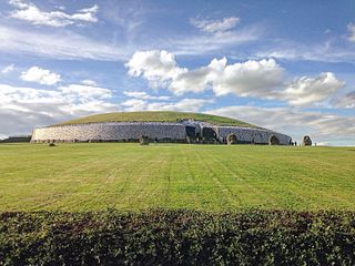
Newgrange is a prehistoric monument in County Meath in Ireland, located on a rise overlooking the River Boyne, 8 kilometres (5.0 mi) west of Drogheda. It is an exceptionally grand passage tomb built during the Neolithic Period, around 3200 BC, making it older than Stonehenge and the Egyptian pyramids. It is aligned on the winter solstice sunrise. Newgrange is the main monument in the Brú na Bóinne complex, a World Heritage Site that also includes the passage tombs of Knowth and Dowth, as well as other henges, burial mounds and standing stones.

Weißenfels was a district (Kreis) in the south of Saxony-Anhalt, Germany. Neighboring districts were Burgenlandkreis, Merseburg-Querfurt and the Saxon district Leipziger Land.

Henge Type of Neolithic earthwork

There are three related types of Neolithic earthwork that are all sometimes loosely called henges. The essential characteristic of all three is that they feature a ring-shaped bank and ditch, with the ditch inside the bank. Because the internal ditches would have served defensive purposes poorly, henges are not considered to have been defensive constructions. The three henge types are as follows, with the figure in brackets being the approximate diameter of the central flat area:

  1. Henge (> 20 m). The word henge refers to a particular type of earthwork of the Neolithic period, typically consisting of a roughly circular or oval-shaped bank with an internal ditch surrounding a central flat area of more than 20 m (66 ft) in diameter. There is typically little if any evidence of occupation in a henge, although they may contain ritual structures such as stone circles, timber circles and coves. Henge monument is sometimes used as a synonym for henge. Henges sometimes, but by no means always, featured stone or timber circles, and circle henge is sometimes used to describe these structures. The three largest stone circles in Britain are each within a henge. Examples of henges without significant internal monuments are the three henges of Thornborough Henges. Although having given its name to the word henge, Stonehenge is atypical in that the ditch is outside the main earthwork bank.
  2. Hengiform monument (5 – 20 m). Like an ordinary henge, except the central flat area is between 5 and 20 m (16–66 ft) in diameter, they comprise a modest earthwork with a fairly wide outer bank. The terms Mini henge or Dorchester henge are sometimes used as synonyms for hengiform monument. An example is the Neolithic site at Wormy Hillock Henge.
  3. Henge enclosure (> 300 m). A Neolithic ring earthwork with the ditch inside the bank, with the central flat area having abundant evidence of occupation and usually being more than 300 m (980 ft) in diameter. Some true henges are as large as this, but lack evidence of domestic occupation. Super henge is sometimes used as a synonym for a henge enclosure. However, sometimes Super henge is used to indicate size alone rather than use, e.g. "Marden henge ... is the least understood of the four British 'superhenges' ".
Nebra sky disc Bronze artefact, c. 1600 BCE, found in Nebra, Germany

The Nebra sky disc is a bronze disc of around 30 cm (12 in) diameter and a weight of 2.2 kg (4.9 lb), having a blue-green patina and inlaid with gold symbols. These symbols are interpreted generally as the Sun or full moon, a lunar crescent, and stars. Two golden arcs along the sides, interpreted to mark the angle between the solstices, were added later. A final addition was another arc at the bottom with internal parallel lines.

Göbekli Tepe Neolithic archaeological site in Turkey

Göbekli Tepe (Turkish: [gœbecˈli teˈpe], "Potbelly Hill"; is a Neolithic archaeological site in the Southeastern Anatolia Region of Turkey. Dated to the Pre-Pottery Neolithic, between c. 9500 and 8000 BCE, the site comprises a number of large circular structures supported by massive stone pillars – the world's oldest known megaliths. Many of these pillars are richly decorated with abstract anthropomorphic details, clothing, and reliefs of wild animals, providing archaeologists rare insights into prehistoric religion and the particular iconography of the period. The 15 m -high, 8 ha tell also includes many smaller rectangular buildings, quarries, and stone-cut cisterns from the Neolithic, as well as some traces of activity from later periods.

Durrington Walls Late Neolithic palisaded enclosure

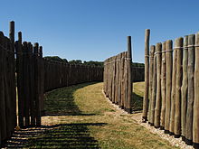
Durrington Walls is the site of a large Neolithic settlement and later henge enclosure located in the Stonehenge World Heritage Site in England. It lies 2 miles (3.2 km) north-east of Stonehenge in the parish of Durrington, just north of Amesbury in Wiltshire. The henge is the second-largest Late Neolithic palisaded enclosure known in the United Kingdom, after Hindwell in Wales.

Bylany (archaeological site)

Bylany is a Danubian Neolithic archaeological site located around 65 km (40 mi) east of Prague in the Czech region of Bohemia. Excavation began in 1955 and work continues today.

The Sanctuary Prehistoric site in Wiltshire, England

The Sanctuary was a stone and timber circle near the village of Avebury in the south-western English county of Wiltshire. Excavation has revealed the location of the 58 stone sockets and 62 post-holes. The ring was part of a tradition of stone circle construction that spread throughout much of Britain, Ireland, and Brittany during the Late Neolithic and Early Bronze Age, over a period between 3300 and 900 BCE. The purpose of such monuments is unknown, although archaeologists speculate that the stones represented supernatural entities for the circle's builders.

Timber circle Rings of upright wooden posts

In archaeology, timber circles are rings of upright wooden posts, built mainly by ancient peoples in the British Isles and North America. They survive only as gapped rings of post-holes, with no evidence they formed walls, making them distinct from palisades. Like stone circles, it is believed their purpose was ritual, ceremonial, and/or astronomical.

Neolithic circular enclosures in Central Europe Neolithic earthworks

Approximately 120–150 Neolithic earthworks enclosures are known in Central Europe. They are called Kreisgrabenanlagen in German, or alternatively as roundels. They are mostly confined to the Elbe and Danube basins, in modern-day Germany, Austria, Czech Republic, Slovakia, as well as the adjacent parts of Hungary and Poland, in a stretch of Central European land some 800 km (500 mi) across. They date to the first half of the 5th millennium BC; they are associated with the late Linear Pottery culture and its local successors, the Stroke-ornamented ware and Lengyel cultures. The best known and oldest of these Circular Enclosures is the Goseck circle, constructed c. 4900 BC.

Nabta Playa Region in the Nubian Desert

Nabta Playa was once a large internally drained basin in the Nubian Desert, located approximately 800 kilometers south of modern-day Cairo or about 100 kilometers west of Abu Simbel in southern Egypt, 22.51° north, 30.73° east. Today the region is characterized by numerous archaeological sites. The Nabta Playa archaeological site, one of the earliest of the Egyptian Neolithic Period, is dated to circa 7500 BC.

Goseck Municipality in Saxony-Anhalt, Germany

Goseck is a municipality lying on the river Saale, in the Burgenlandkreis district of the German state of Saxony-Anhalt.

Straight-tusked elephant Extinct species of mammal

The straight-tusked elephant is an extinct species of elephant that inhabited Europe and Western Asia during the Middle and Late Pleistocene. Recovered individuals have reached up to 4–4.2 metres (13.1–13.8 ft) in height, and an estimated 11.3–15 tonnes in weight. The straight-tusked elephant probably lived in small herds, flourishing in interglacial periods, when its range would extend as far north as Great Britain. Isolated tusks are often found while partial or whole skeletons are rare, and there is evidence of predation by early humans. It is the ancestral species of most dwarf elephants that inhabited islands in the Mediterranean.

Circular rampart Embankment built in the shape of a circle

A circular rampart is an embankment built in the shape of a circle that was used as part of the defences for a military fortification, hill fort or refuge, or was built for religious purposes or as a place of gathering.

An astronomical complex or commemorative astronomical complex is a series of man-made structures with an astronomical purpose. It has been used when referring to a group of Megalithic structures that it is claimed show high precision astronomical alignments. For the study of Archaeoastronomy, such complexes of similar structures are required for adequate measurement and calculation to ensure that similar celestial sightlines were intended by the designers. These arrangements have also been known as observational, ceremonial or ritual complexes with importance for the study of prehistoric cultures.

A polygonal dolmen is a megalithic architectural structure and often depicted as the archetypal dolmen.

Cahokia Woodhenge Series of large timber circles at the Mississippian culture Cahokia archaeologial site, US

The Cahokia Woodhenge was a series of large timber circles located roughly 850 metres (2,790 ft) to the west of Monks Mound at the Mississippian culture Cahokia archaeological site near Collinsville, Illinois. They are thought to have been constructed between 900 and 1100 CE; with each one being larger and having more posts than its predecessor. The site was discovered as part of salvage archaeology in the early 1960s interstate highway construction boom, and one of the circles was reconstructed in the 1980s. The circle has been used to investigate archaeoastronomy at Cahokia. Annual equinox and solstice sunrise observation events are held at the site.

Shriver Circle Earthworks

The Shriver Circle Earthworks are an Ohio Hopewell culture archaeological site located in Chillicothe in Ross County, Ohio. At 1,200 feet (370 m) in diameter the site is one of the largest Hopewell circular enclosures in the state of Ohio.

References

  1. 1 2 3 4 5 6 7 8 9 Literski-Henkel, Norma (February 2017). "Das "Sonnenobservatorium" von Goseck" [The "solar observatory" of Goseck]. Archäologie in Deutschland (in German). Stuttgart, Germany: Konrad Theiss (Wissenschaftliche Buchgesellschaft). pp. 70–71. ISSN   0176-8522.
  2. Bertemes, François; Northe, Andreas (2007). "Der Kreisgraben von Goseck: ein Beitrag zum Verständnis früher monumentaler Kultbauten Mitteleuropas" [The circular ditch of Goseck: A contribution to the understanding of early monumental cult buildings of Central Europe]. In Schmotz, Karl (ed.). Vorträge des 25. Niederbayerischen Archäologentages [Lectures of the 25th Lower Bavarian Archaeological Day] (in German). Rahden/Westf: Leidorf. p. 137-168 (at 150). ISBN   978-3-89646-236-7.
  3. "Menschenopfer in Europas ältestem Sonnenobservatorium". Frankfurter Allgemeine Zeitung . 8 August 2003.
  4. Ralf Schwarz, Kreisgrabenanlagen der Stichbandkeramikkultur in Sachsen-Anhalt, Neolithic Circular Enclosures in Europe, International Workshop in Goseck (Saxony-Anhalt, Germany) 7-9 May 2004 (abstract)
  5. François Bertemes, Peter F. Biehl, Andreas Northe, Olaf Schröder: Die neolithische Kreisgrabenanlage von Goseck, Ldkr. Weißenfels. In: Archäologie in Sachsen-Anhalt. NF Bd. 2, 2004, p. 137–145.
  6. Boser, Ulrich (July 2006). "Solar Circle". Archaeology. Vol. 59, no. 4. Retrieved 14 March 2018.
  7. Mukerjee, Madhusree (8 December 2003). "Circles for Space: Scientific American". Scientific American. Archived from the original on 15 October 2010.

Further reading

Coordinates: 51°11′54″N11°51′53″E / 51.19833°N 11.86472°E / 51.19833; 11.86472