
Little River County is a county located on the southwest border of the U.S. state of Arkansas, bordering a corner with Texas and Oklahoma. As of the 2020 census, the population was 12,026. The county seat is Ashdown.

Morrilton is a city in Conway County, Arkansas, United States, less than 50 miles (80 km) northwest of Little Rock. The city is the county seat of Conway County. The population was 6,992 at the 2020 United States census.
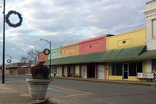
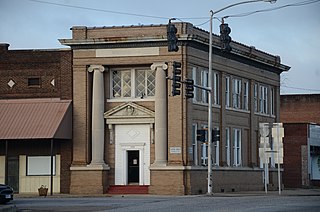
Ashdown is a city in Little River County, Arkansas, United States. The community was incorporated in 1892 and has been the county seat since 1906. Located within the Arkansas Timberlands between the Little River and the Red River, Ashdown's economy and development have historically been tied to the timber industry. Timber is still a major industry here.

Highway 16 is an east–west state highway in Arkansas. The route begins in Siloam Springs at US Highway 412 (US 412) and Highway 59 and runs east through Fayetteville and the Ozark National Forest to US Highway 67 Business (US 67B) in Searcy. Highway 16 was created during the 1926 Arkansas state highway numbering, and today serves as a narrow, winding, 2-lane road except for overlaps of 10 miles (16 km) through Fayetteville. Much of the highway winds through the Ozarks, including the Ozark National Forest, where a portion of the highway is designated as an Arkansas Scenic Byway. The route has two spur routes in Northwest Arkansas; in Fayetteville and Siloam Springs.

This is a list of the National Register of Historic Places listings in Detroit, Michigan.

U.S. Route 64 is a U.S. highway running from Teec Nos Pos, Arizona east to Nags Head, North Carolina. In the U.S. state of Arkansas, the route runs 246.35 miles (396.46 km) from the Oklahoma border in Fort Smith east to the Tennessee border in Memphis. The route passes through several cities and towns, including Fort Smith, Clarksville, Russellville, Conway, Searcy, and West Memphis. US 64 runs parallel to Interstate 40 until Conway, when I-40 takes a more southerly route.

Highway 14 is an east–west state highway in Arkansas. The route of 227.35 miles (365.88 km) begins at Boat Dock Road near Table Rock Lake and runs east to Mississippi County Route W1020 (CR W1020) at Golden Lake. Segments of the highway are part of two Arkansas Scenic Byways: Sylamore Scenic Byway in the Ozark National Forest and the Crowley's Ridge Parkway atop Crowley's Ridge.

The South Main Street Commercial Historic District of Little Rock, Arkansas is a historic district encompassing a five-block stretch of South Main Street, just south of the city's downtown area. Developed between about 1905 and 1950, the section of South Main between 12th and 17th streets represents an architectural cross-section of the commercial development that took place in the city during that time. Early buildings, such as the 1905 Lincoln Building, were Classical Revival in style, while generational changes in style are exemplified by the presence of Craftsman and Art Deco buildings. One residential building, the First Hotze House, predates the area's commercial development, and stands as a reminder of its residential past.

The Downtown Adrian Commercial Historic District is a historic district comprising the downtown area of Adrian, Michigan. It was designated as a Michigan Historic Site and added to the National Register of Historic Places on April 17, 1986. The district is roughly bounded on the north by Toledo Street, on the east by North Broad Street, on the south by East Church Street, and on the west by North Winter Street (M-52), West Maumee Street, and the River Raisin. Most of the district is enclosed by the US-223 Business Route, although the two are not conterminous.

Twelve special routes of U.S. Route 63 currently exist. Arkansas and Missouri each contain five, with two in Iowa. There are also five former routings that have been removed from the system.

Highway 190 is a designation for four state highways in Arkansas. Three are low-traffic rural highways in Grant County, with one designation along city streets in Pine Bluff. The rural segments were created in 1965 and 1966, with the Pine Bluff section created in 2000 as a renumbering of Highway 104. All segments are maintained by the Arkansas Department of Transportation (ARDOT).

U.S. Highway 71 is a U.S. highway that runs from Krotz Springs, LA to the Fort Frances–International Falls International Bridge at the Canadian border. In Arkansas, the highway runs from the Louisiana state line near Doddridge to the Missouri state line near Bella Vista. In Texarkana, the highway runs along State Line Avenue with US 59 and partially runs in Texas. Other areas served by the highway include Fort Smith and Northwest Arkansas.
The Lake Village Commercial Historic District encompasses the historic commercial heart of Lake Village, Arkansas, the county seat of Chicot County in the Mississippi River delta region of southeastern Arkansas. The district covers about six square blocks of downtown Lake Village, bounded roughly by Jackson Street to the north, Lakeshore Drive to the east, Church Street to the south, and Chicot Street to the west. This area represents the growth of Lake Village during its period of greatest prosperity, between 1906 and 1960. The city's growth was spurred by the arrival of the railroad in 1903, and most of the district's buildings were built between 1900 and 1930. Most of the buildings are vernacular commercial buildings; the John Tushek Building at 202 Main Street is one interesting example of Beaux Arts styling, and 218–222 Main Street has some Italianate styling. The district includes the Lake Village Confederate Monument, which has been a local landmark since 1910.

The El Dorado Commercial Historic District encompasses the historic commercial heart of downtown El Dorado, Arkansas. The city serves as the seat of Union County, and experienced a significant boom in growth during the 1920s, after oil was discovered in the area. The business district that grew in this time is anchored by the Union County Courthouse, at the corner of Main and Washington Streets, where the Confederate memorial is also located. The historic district listed on the National Register of Historic Places in 2003 includes the city blocks surrounding the courthouse, as well as several blocks extending east along Main Street and south along Washington Street. Most of the commercial buildings are one and two stories in height and are built of brick. Notable exceptions include the Exchange Bank building, which was, at nine stories, the county's first skyscraper, and the eight-story Murphy Oil building. There are more than forty contributing properties in the district.
The Prescott Commercial Historic District encompasses the historic commercial core of Prescott, Arkansas, the county seat of Nevada County. Prescott was laid out in 1873, after the railroad was built through the area that is now Nevada County, and the railroad has played a significant role in the city's development. The railroad today bisects the commercial core of the city, which extends for several city blocks away from the railroad. The historic district includes all of the major civic buildings of the city, including the courthouse, post office, and the old Prescott City Jail.

The Hope Historic Commercial District encompasses a two-block area of downtown Hope, Arkansas. The 18-acre (7.3 ha) district is bounded on the north by the railroad tracks, on the east by Walnut Street, the west by Elm Street, and the south by 3rd Street. The area consists for the most part of commercial brick buildings one or two stories in height, with relatively plain styling. Most of these were built between 1880 and 1945, the major period of Hope's development. The most architecturally significant buildings in the district are the Brundidge Building, an 1893 Romanesque Revival structure, and the Renaissance Revival former post office building.

The Conway Commercial Historic District encompasses the historic commercial heart of Conway, Arkansas. The area, roughly bounded by Main Street on the south, Harkrider and Spencer Streets on the east, just south of Mill Street to the north, and Locust Street to the west, was developed between 1879 and 1960, and includes representative architecture from four major phases of the city's development. It includes the city's oldest commercial building, the 1879 Frauenthal & Schwarz Building.

The Little River County Training School Historic District encompasses the surviving buildings of a defunct once-segregated vocational school in Ashdown, Arkansas. It occupies two city blocks, bounded by Martin Luther King, Jr. Drive, and Hamilton, Wood, and Byrne Streets. The surviving buildings are a classroom building, the gymnasium, and the shop building. All are single story brick structures, and were built between 1962 and 1965. They represent the last surviving buildings in Little River County that were used as segregated facilities. The school was first developed in the 1920s, with funding and other support from the Rosenwald Fund; a building burned down in 1957, and another in 1980. The school was used in an integrated setting, mainly as a junior high school, until 1979, when the new Junior High opened for the 1979–1980 school year. The building on Hamilton Street was utilized as a Primary Center until it burned, in 1980.

The South Main Street Residential Historic District encompasses a residential area south of downtown Little Rock, Arkansas. The area, extending along South Main Street roughly between 19th and 23rd Streets, was developed between about 1880 and 1945, and includes a well-preserved set of residential architecture from that period. Notable buildings include the Luxor Apartments, the Holcomb Court Apartments, and the Ada Thompson Memorial Home.

Highway 51 is a designation for two north–south state highways in Southwest Arkansas. One route of 53.37 miles (85.89 km) begins Highway 53 near Whelen Springs and runs north to US Highway 67 in Donaldson. A second route of 7.92 miles (12.75 km) runs parallel to US 270 northwest of Malvern. Both routes are maintained by the Arkansas Department of Transportation (ArDOT).


 2016
2016 2016
2016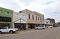 2016
2016

