Related Research Articles

Van Buren is the second-largest city in the Fort Smith, Arkansas–Oklahoma Metropolitan Statistical Area and the county seat of Crawford County, Arkansas, United States. The city is located directly northeast of Fort Smith at the Interstate 40 – Interstate 540 junction. The city was incorporated in 1845 and as of the 2020 census had a population of 23,218, ranking it as the state's 21st largest city.
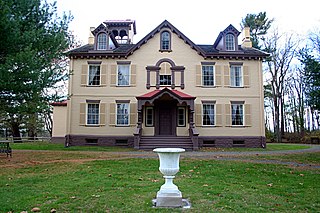
Martin Van Buren National Historic Site is a unit of the United States National Park Service in Columbia County, New York, 1 mile (1.6 km) south of the village of Kinderhook, 125 miles (201 km) north of New York City and 20 miles (32 km) south of Albany. The National Historic Site preserves the Lindenwald estate owned by Martin Van Buren, the eighth president of the United States. Van Buren purchased the 36-room mansion during his presidency in 1839, and it became his home and farm from his leaving office in 1841 until his death in 1862.

U.S. Route 64 is a U.S. highway running from Teec Nos Pos, Arizona east to Nags Head, North Carolina. In the U.S. state of Arkansas, the route runs 246.35 miles (396.46 km) from the Oklahoma border in Fort Smith east to the Tennessee border in Memphis. The route passes through several cities and towns, including Fort Smith, Clarksville, Russellville, Conway, Searcy, and West Memphis. US 64 runs parallel to Interstate 40 until Conway, when I-40 takes a more southerly route.
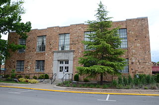
The Van Buren County Courthouse is located at the corner of Griggs and Main Streets in downtown Clinton, Arkansas, the county seat of Van Buren County. It is a two-story masonry structure, built primarily out of local stone. Its main facade is five bays wide, each flanked by broad sections that project a small amount. The main entrance is in the center bay, with a concrete surround of pilasters and a tall corniced entablature. It was built in 1934 with funding support from the federal Works Progress Administration, and was the county's third courthouse to be located in Clinton.

This is a list of the National Register of Historic Places listings in Van Buren County, Arkansas.
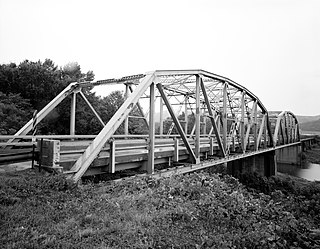
The Lee Creek Bridge in Natural Dam, Arkansas was a Pennsylvania through truss bridge that was built in 1934. It was a twin-span bridge with a total length of 587 feet (179 m), which carried Arkansas Highway 59 across Lee Creek. It rested on concrete piers and abutments, had a vertical clearance of 14 feet (4.3 m) and had a roadbed 22 feet (6.7 m) wide.

Highway 95 is a designation for a north–south state highway in north central Arkansas. The route runs 49.40 miles (79.50 km) runs north from US Highway 64 and Highway 113 in Morrilton north to Highway 330.

Highway 285 is a designation for three north–south state highways in central Arkansas. One route of 6.17 miles (9.93 km) runs north from US Route 65 near Greenbrier to Woolly Hollow State Park in Faulkner County. A second route of 9.90 miles (15.93 km) begins at Highway 25 in Wooster and runs north to Highway 124 at Martinville, also in Faulkner County. A third segment runs north from US 65 in Damascus to Highway 92 at Rabbit Ridge in Van Buren County.

The Van Buren Historic District encompasses eight blocks of historic buildings along Main Street in Van Buren, Arkansas. Many of the structures are pre-1920 Victorian and Italianate buildings closely related to the history of commerce in the city. Positioned between the city's train depot and the Arkansas River, the businesses constituting the Van Buren Historic District have played a vital role in the history and economy of the city and region. The district was placed on the National Register of Historic Places as a National Historic District on April 30, 1976.

The Paw Paw City Hall is a government building located at 111 East Michigan Avenue in Paw Paw, Michigan. It was designated a Michigan State Historic Site in 1971 and listed on the National Register of Historic Places in 1972.

The Drennen-Scott House is a historic house museum on North 3rd Street in Van Buren, Arkansas. It is a single-story log structure, finished in clapboards, with a side-gable roof that has a slight bell-cast shape due to the projection of the roof over the front porch that extends across the width of its main block. The house was built in 1836 by John Drennen, one of Van Buren's first settlers. Drennen and his brother-in-law David Thompson were responsible for platting the town, and Drennen was politically active, serving in the territorial and state legislatures, and at the state constitutional convention. The house remained in the hands of Drennen descendants until it was acquired by the University of Arkansas at Fort Smith, which operates it as a house museum.

Fairview Cemetery, also known as the Van Buren Cemetery, is a historic cemetery on the east side of Arkansas Highway 59 in Van Buren, Arkansas. The 10-acre (4.0 ha) cemetery's oldest graves date to 1816, the period of the region's settlement, and include some of Van Buren's first settlers. First established as an informal private burial ground, it was given to the city by John Drennen in 1846.
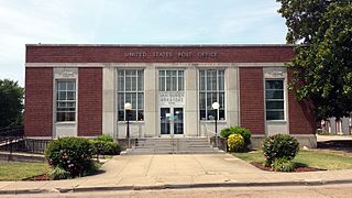
The Van Buren Post Office is located at 22 South 7th Street in Van Buren, Arkansas. It is a single-story brick and stone building, with restrained Art Deco styling. The main entrance is topped by a panel with aluminum signage identifying the building, with a large window above. It is flanked by tall pilasters, beyond which are tall windows and another pair of pilasters. The outer bays of the facade, set off from the center, have windows topped by decorative Art Deco panels. The post office was built in 1936, and features a mural by E. Martin Hennings, that was executed in 1940 with funding from the Treasury Department's Section of Fine Arts.
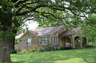
The Melvin Chrisco House is a historic house at 237 Alvin Brown Road in Damascus, Arkansas. It is a single-story wood-frame structure, with a gabled roof and an exterior of stone veneer with cream-colored brick trim. A multi-arched gabled-roofed porch shelters the front entrance. The house was built in 1947, its exterior finished by the regionally prominent African-American mason Silas Owens, Sr. It exhibits hallmarks of Owens's work, including herringbone patterning in the stone work, arched porch openings, and the use of cream brick in quoined patterns on corners and openings.
The Edgemont Shelter, also designated by the Smithsonian trinomial 3VB6, is a prehistoric rock art site in Van Buren County, Arkansas. Located on a bluff overlooking Greers Ferry Lake, it consists of a panel extensively painted with petroglyphs. The site has been dated to about 1500.

The Joclin-Bradley-Bowling House is a historic house at 160 Arkansas Highway 95W in Clinton, Arkansas. It is a 1+1⁄2-story wood-frame structure, with a front-facing gabled roof, weatherboard siding, and a concrete block foundation. The roof has exposed rafter ends in the gables, and shelters a recessed porch which is supported by bracketed square posts set on brick piers. The house was built in 1854, and extensively altered in 1921 to give it its current Craftsman appearance.

The Middle Fork of the Little Red River Bridge, also known as the Shirley Railroad Bridge, is a historic bridge in Shirley, Arkansas. It is a single-span iron Baltimore through truss, with a main span 153 feet (47 m) long, and steel beam approach spans giving it a total length of 339 feet (103 m). The main span rests on large concrete piers set in the river. The bridge was built in 1908 for the Missouri and North Arkansas Railroad, and carried the railroad until 1949. In 1978 the tracks were covered by a concrete deck, and the bridge was converted to single-lane vehicular road use, carrying County Road 125.

The Van Buren County Road 2E Bridge is a historic bridge in rural southwestern Van Buren County, Arkansas. It is a three-span open concrete masonry structure, with each span measuring 12 feet (3.7 m) in length, carrying County Road 2E across an unnamed tributary of Driver's Creek. The bridge rests on piers and abutments of stone and concrete, and has a roadway deck 19.9 feet (6.1 m) wide. It was built in 1940 with funding from the Works Progress Administration, and is a well-preserved example of a period concrete bridge.
References
- 1 2 "National Register Information System". National Register of Historic Places . National Park Service. July 9, 2010.
- ↑ Christ, Mark; Slater, Cathryn (2000). Sentinels of history: reflections on Arkansas properties on the National Register of Historic Places. University of Arkansas Press. ISBN 9781557286055.
| Topics | |
|---|---|
| Lists by state |
|
| Lists by insular areas | |
| Lists by associated state | |
| Other areas | |
| Related | |
| | This article about a property in Van Buren County, Arkansas on the National Register of Historic Places is a stub. You can help Wikipedia by expanding it. |