Petit Jean State Park is a 3,471-acre (1,405 ha) park in Conway County, Arkansas managed by the Arkansas Department of Parks and Tourism. It is located atop Petit Jean Mountain adjacent to the Arkansas River in the area between the Ouachita Mountains and Ozark Plateaus.
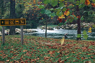
Bennett Spring State Park is a public recreation area located in Bennett Springs, Missouri, twelve miles (19 km) west of Lebanon on Highway 64 in Dallas and Laclede counties. It is centered on the spring that flows into the Niangua River and gives the park its name. The spring averages 100 million gallons of daily flow. The park offers fly fishing, camping, canoeing, hiking, and other activities.
Located near Dardanelle, Arkansas and rising about 1,350 feet (410 m) above the mountain valleys of west-central Arkansas to an elevation of about 1,755 feet (535 m) above sea level, Mount Nebo has views of 34,000 acres (140 km2) Lake Dardanelle, the Arkansas River and the surrounding mountain ridges. Atop this biblically named plateau is Mount Nebo State Park. Developed as a resort area in the late 19th century, it became a state park in 1928, its early development spearheaded by the Civilian Conservation Corps. Park activities include hiking, camping, and other outdoor pursuits.

The Centennial Baptist Church is a historic church building at the corner of York and Columbia Streets in Helena, Arkansas. It is significant for its association with Elias Camp Morris (1855-1922), who was the pastor of the church from 1879 and who was a driving force in the establishment of the National Baptist Convention, USA, Inc. Morris served as the convention's president from 1895 until his death, and his church served functionally as the organization's headquarters. The church was listed on the National Register of Historic Places in 1987, and was declared a National Historic Landmark in 2003.

Devil's Den State Park is a 2,500-acre (1,000 ha) Arkansas state park in Washington County, near West Fork, Arkansas in the United States. The park was built by the Civilian Conservation Corps, beginning in 1933. Devil's Den State Park is in the Lee Creek Valley in the Boston Mountains, which are the southwestern part of The Ozarks. The park, with an 8 acres (3.2 ha) CCC-built lake, is open for year-round recreation, with trails for hiking, mountain biking and horseback riding. Devil's Den State Park also has several picnic areas, a swimming pool and cabins, with camping sites ranging from modern to primitive. Fossils of coral and crinoids can be found along the banks and within Lee Creek at Devil's Den State Park.

The Bear Brook State Park Civilian Conservation Corps (CCC) Camp Historic District is the only surviving Civilian Conservation Corps work camp in New Hampshire. Located in Bear Brook State Park, in Allenstown, the camp's facilities have been adaptively reused to provide space for park administration and a small museum. It is located in the northwestern portion of the park, south of Deerfield Road. It is also believed to be one of the few relatively intact CCC camps in the nation. The district was listed on the National Register of Historic Places in 1992.

The Crowley's Ridge State Park Bridge is a historic masonry stone arch bridge in Crowley's Ridge State Park, near Walcott, Arkansas. The bridge carries the main access road to the park across a drainage ditch. It is a rusticated stone structure, about 40 feet (12 m) long, that was built c. 1935 by crews of the Civilian Conservation Corps (CCC) that were developing the park. It is one of several CCC-built structures still standing in the park, and is a well-built example of the rustic architecture popularized by the CCC.

Shady Lake Recreation Area is a campground and public recreation area in southwestern Ouachita National Forest, southwest of Mena, Arkansas and west of Glenwood, Arkansas. The area is oriented around Shady Lake, a body of water on the South Fork Saline River impounded by a dam built c. 1940 by the Civilian Conservation Corps (CCC). The area is administered by the United States Forest Service (USFS).
The Powder Magazine is a surviving structure of the Civilian Conservation Corps (CCC) camp of the 1707th Company. Located in Ouachita National Forest in the northeast corner of Scott County, Arkansas, it is a small stone and concrete structure about 4 by 3 feet and between 3 and 4-1/2 feet in height. It is located about 50 yards (46 m) south of the T-shaped junction of two forest roads in 1993) on top of a ridge above Dutch Creek. The structure was built to house the camp's explosives, which were typically used by the camp crew for road and bridge building projects.
Camp Clearfork is a group use recreational facility in Ouachita National Forest, west of the city of Hot Springs, Arkansas. It is located at the end of Camp Clearfork Trail, south of United States Route 270. The camp was developed in the 1930s by the Civilian Conservation Corps (CCC), and includes cabins, a recreation hall, and Camp Clearfork Reservoir, impounded by a CCC-built dam.
The CCC Company 741 Powder Magazine Historic District encompasses two structures built by Camp 741 of the Civilian Conservation Corps c. 1936. The camp, the first established in Arkansas, used these structures to store explosive materials used in road and bridge construction projects. The two structures have concrete bases and tops, and have walls of cut fieldstone and concrete. The main magazine is 8 by 16 feet, and the blasting cap storage building is about 10 by 10 feet. The main magazine is located a short way north of Forest Road 177M in Ouachita National Forest; the blasting cap storage building is about 113 metres (371 ft) to its northwest.
The Melvin Chrisco House is a historic house at 237 Alvin Brown Road in Damascus, Arkansas. It is a single-story wood-frame structure, with a gabled roof and an exterior of stone veneer with cream-colored brick trim. A multi-arched gabled-roofed porch shelters the front entrance. The house was built in 1947, its exterior finished by the regionally prominent African-American mason Silas Owens, Sr. It exhibits hallmarks of Owens's work, including herringbone patterning in the stone work, arched porch openings, and the use of cream brick in quoined patterns on corners and openings.

Gifford Woods State Park is a state park located at the base of Pico Peak in Killington, Vermont. The wooded park provides camping, picnic, and fishing facilities, and has hiking trails, including a portion of the Appalachian Trail. It preserves an area of old-growth forest that has been designated a National Natural Landmark, and is accessible via an interpretive trail. The park was established in 1931. Part of it is listed on the National Register of Historic Places, for facilities developed by the Civilian Conservation Corps in the 1930s.
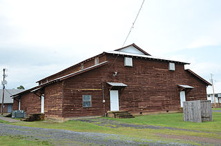
The Damascus Gymnasium is a historic school building on Arkansas Highway 285 in Damascus, Arkansas. It is a rustic 1+1⁄2-story wood-frame structure, with a central clerestory section covered by a gable-on-hip roof, and side wings covered by a shed roof. The main entrance, on the east side, is sheltered by a gabled porch, with secondary entrances on the south side, each sheltered by a gable roof supported by large brackets. The gymnasium was built in 1933 with funding support from the Works Progress Administration.
Beeds Lake State Park is located northwest of Hampton, Iowa, United States. It was listed has a historic district on the National Register of Historic Places as Beeds Lake State Park, Civilian Conservation Corps Area in 1990. At the time of its nomination it contained 21 resources, which included one contributing building, 15 contributing structures, and five non-contributing structures. The 319-acre (129 ha) park surrounds a 99-acre (40 ha) reservoir. It features hiking trails, boating, fishing, swimming, camping, picnic areas and shelters, lodges and concessions.

The Carl and Esther Lee House is a historic house at 17493 United States Route 65 West in Damascus, Arkansas. It is a 1+1⁄2-story wood-frame structure, with a stone veneer exterior and cream-colored brick trim. The front facade has projecting gable sections, with a porch sheltered by one such section with curved-arch openings. The larger gables have sunburst brick designs near their peaks. The house was built about 1948; the exterior stonework was done by Silas Owens, Sr., a regionally prominent stonemason. The house exhibits many of Owens's hallmarks, including the use of cream-colored brick, herringbone-patterned stonework, and arched openings.

The Camp Ouachita Girl Scout Camp Historic District encompasses a campground area built by crews of the Civilian Conservation Corps in the 1930s on the northern shore of Lake Sylvia, a man-made lake in the eastern part of Ouachita National Forest. The center of the campground, including its Great Hall and administration buildings, is located at the northern tip of Lake Sylvia, with cabins, comfort facilities, and other infrastructure arrayed around the northern and western sides of the lake. It was the first Girl Scout camp in the state, and is a well-preserved example of the Rustic style of architecture for which the CCC is known.

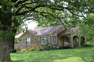
Mather Lodge is a historic park facility at Petit Jean State Park in Conway County, Arkansas. It is the centerpiece of the park's developed infrastructure, providing lodging, a meeting and function space, and a restaurant for park visitors. The lodge was built in 1935 by a crew of the Civilian Conservation Corps, and is one of the fine examples of the CCC architecture of Petit Jean State Park. It is built in the Rustic style for which the CCC became well known.

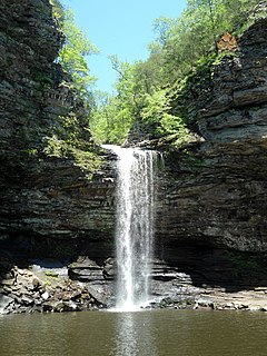
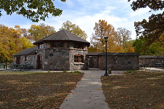
The Lake Bailey–Roosevelt Lake Historic District encompasses a landscape and buildings developed by the Civilian Conservation Corps in Petit Jean State Park, Conway County, Arkansas. The district includes both Lake Bailey and Roosevelt Lake, man-made by CCC-built dams, along with the waterfall between the two, as well as a boathouse, shelter and bathhouse, and the Cedar Creek Bridge, which crosses Roosevelt Lake at its outlet. A unique artistic feature built by the CCC are a series of what appear to be wooden stumps poking out of Roosevelt Lake, which are actually built out of concrete. These facilities were built about 1935, and form a subset of park's surviving CCC architecture.

The Henry R. Koen Forest Service Building is a historic federal government office building at 605 West Main Street in Russellville, Arkansas. It is two story stone and frame structure, built in 1939 by crews of the Civilian Conservation Corps. The building is distinctive urban adaptation of the Rustic style for which the CCC became well known. Originally built to house both the main offices of the Ozark-St. Francis National Forest and local CCC administrators, it is now used exclusively by the former.


