This is a list of rivers of the U.S. state of Tennessee :
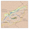
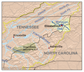
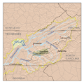
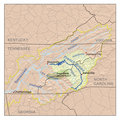
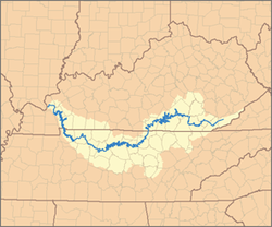
This list is arranged by drainage basin, with respective tributaries indented under each larger stream's name. All rivers in Tennessee ultimately flow to the Gulf of Mexico.
Elizabethton is a city in, and the county seat of Carter County, Tennessee, United States. Elizabethton is the historical site of the first independent American government located west of both the Eastern Continental Divide and the original Thirteen Colonies.
The Tennessee River is the largest tributary of the Ohio River. It is approximately 652 miles (1,049 km) long and is located in the southeastern United States in the Tennessee Valley. The river was once popularly known as the Cherokee River, among other names, as the Cherokee people had their homelands along its banks, especially in what are now East Tennessee and northern Alabama. Additionally, its tributary, the Little Tennessee River, flows into it from Western North Carolina and northeastern Georgia, where the river also was bordered by numerous Cherokee towns. Its current name is derived from the Cherokee town, Tanasi, which was located on the Tennessee side of the Appalachian Mountains.
The Cumberland River is a major waterway of the Southern United States. The 688-mile-long (1,107 km) river drains almost 18,000 square miles (47,000 km2) of southern Kentucky and north-central Tennessee. The river flows generally west from a source in the Appalachian Mountains to its confluence with the Ohio River near Paducah, Kentucky, and the mouth of the Tennessee River. Major tributaries include the Obey, Caney Fork, Stones, and Red Rivers.
The Collins River is a 67-mile-long (108 km) stream in the east-central portion of Middle Tennessee in the United States. It is a tributary of the Caney Fork, and is part of the Cumberland, Ohio and Mississippi watersheds. The river drains the scenic Savage Gulf area, located just below the river's source, and empties into Great Falls Lake at Rock Island State Park.
The Rocky River is a 31.0-mile-long (49.9 km) stream in the east-central portion of Middle Tennessee in the United States. It is a tributary of the Caney Fork River, and is part of the Cumberland, Ohio and Mississippi watersheds. The lower portion of the river is part of the reservoir created by Great Falls Dam, which is located near the river's confluence with the Caney Fork.
The Falling Water River is a 46.8-mile-long (75.3 km) stream in the east-central portion of Middle Tennessee in the United States. It rises just west of Monterey at the edge of the Cumberland Plateau, and traverses the Eastern Highland Rim before dropping off to the Nashville Basin and emptying into Center Hill Lake along the Caney Fork. The river is noted for the 136-foot (41 m) Burgess Falls, which it spills over near the end of its course.
The Caney Fork River is a river that flows through central Tennessee in the United States, draining a substantial portion of the southwestern Cumberland Plateau and southeastern Highland Rim regions. It is a major tributary of the Cumberland River, and is part of the Cumberland, Ohio and Mississippi basins. The river is 143 miles (230 km) long, and its watershed covers 1,771 square miles (4,590 km2) in eleven counties. Monterey, Baxter, Sparta, Smithville, McMinnville, Altamont, Spencer and Gordonsville are among the towns that are at least partially drained by the river.
Fall Creek Falls State Resort Park is a state park in Van Buren and Bledsoe counties, in the U.S. state of Tennessee. The over 30,638-acre (123.99 km2) park is centered on the upper Cane Creek Gorge, an area known for its unique geological formations and scenic waterfalls. The park's namesake is the 256-foot (78 m) Fall Creek Falls, the highest free-fall waterfall east of the Mississippi River.
Pocket wilderness is a name used by Bowater corporation and the State of Tennessee for any of several tracts of Bowater-owned private land on and near the Cumberland Plateau that the company set aside beginning in 1970 "for preservation in its natural state, with no logging or development other than hiking trails permitted within its boundaries" and registered as Tennessee state natural areas. Several areas formerly managed as Bowater pocket wilderness are now incorporated into state-owned natural areas or National Park Service sites.
The cherry darter is a species of freshwater ray-finned fish, a darter from the subfamily Etheostomatinae, part of the family Percidae, which also contains the perches, ruffes and pikeperches. It is endemic to the upper Caney Fork system of the Cumberland River drainage in the U.S. state of Tennessee.