Related Research Articles

Jackson County is a county located in the U.S. state of Tennessee. The population was 11,638 at the 2010 census. Its county seat is Gainesboro. Jackson is part of the Cookeville Micropolitan Statistical Area.

Spencer is a town in Van Buren County, Tennessee, United States. The population was 1,683 as of the 2010 census. It is the county seat of Van Buren County. It is home to Fall Creek Falls State Park.

The French Broad River is a river in the U.S. states of North Carolina and Tennessee. It flows 218 miles (351 km) from near the town of Rosman in Transylvania County, North Carolina, into Tennessee, where its confluence with the Holston River at Knoxville forms the beginning of the Tennessee River. The river flows through the counties of Transylvania, Buncombe, Henderson, and Madison in North Carolina, and Cocke, Jefferson, Sevier, and Knox in Tennessee. It drains large portions of the Pisgah National Forest and the Cherokee National Forest.

The Little Pigeon River is a river located entirely within Sevier County, Tennessee. It rises from a series of streams which flow together on the dividing ridge between the states of Tennessee and North Carolina, with most of the flow from inside the boundary of the Great Smoky Mountains National Park. The river has three main forks or prongs, East, Middle, and West.

The Collins River is a 67-mile-long (108 km) stream in the east-central portion of Middle Tennessee in the United States. It is a tributary of the Caney Fork, and is part of the Cumberland, Ohio and Mississippi watersheds. The river drains the scenic Savage Gulf area, located just below the river's source, and empties into Great Falls Lake at Rock Island State Park.

The Rocky River is a 31.0-mile-long (49.9 km) stream in the east-central portion of Middle Tennessee in the United States. It is a tributary of the Caney Fork River, and is part of the Cumberland, Ohio and Mississippi watersheds. The lower portion of the river is part of the reservoir created by Great Falls Dam, which is located near the river's confluence with the Caney Fork.
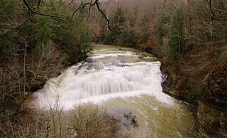
The Falling Water River is a 46.8-mile-long (75.3 km) stream in the east-central portion of Middle Tennessee in the United States. It rises just west of Monterey at the edge of the Cumberland Plateau, and traverses the Eastern Highland Rim before dropping off to the Nashville Basin and emptying into Center Hill Lake along the Caney Fork. The river is noted for the 136-foot (41 m) Burgess Falls, which it spills over near the end of its course.

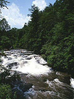
The Caney Fork River is a river that flows through central Tennessee in the United States, draining a substantial portion of the southwestern Cumberland Plateau and southeastern Highland Rim regions. It is a major tributary of the Cumberland River, and is part of the Cumberland, Ohio and Mississippi basins. The river is 143 miles (230 km) long, and its watershed covers 1,771 square miles (4,590 km2) in eleven counties. Monterey, Baxter, Sparta, Smithville, McMinnville, Altamont, Spencer and Gordonsville are among the towns that are at least partially drained by the river.
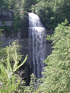
Fall Creek Falls State Resort Park is a state park in Van Buren and Bledsoe counties, in the U.S. state of Tennessee. The over 30,638-acre (123.99 km2) park is centered on the upper Cane Creek Gorge, an area known for its unique geological formations and scenic waterfalls. The park's namesake is the 256-foot (78 m) Fall Creek Falls, the highest free-fall waterfall east of the Mississippi River.
Back Creek is a 59.5-mile-long (95.8 km) tributary of the Potomac River that flows north from Frederick County, Virginia, to Berkeley County in West Virginia's Eastern Panhandle. Back Creek originates along Frederick County's border with Hampshire County, West Virginia, at Farmer's Gap in the Great North Mountain. Its name reflects its location to the west of North Mountain. The perspective of colonists from the east in the 18th century led them to call it "Back Creek", because it lay to the back of North Mountain.
The Soque River and its watershed are located entirely within the county boundaries of Habersham County in northeast Georgia. The Soque is a tributary of the Chattahoochee River. Portions of the river run along State Route 197.

Scott's Gulf is a canyon situated along the Caney Fork River in White County, Tennessee, in the southeastern United States. The canyon stretches for approximately 18 miles (29 km) as the Caney Fork drops from the top of the Cumberland Plateau down to the eastern Highland Rim. This remote section of the river is home to a wilderness area consisting of a largely undisturbed deciduous forest, numerous waterfalls, caves and other geological formations, and Class IV and Class V whitewater rapids.

Ozone Falls State Natural Area is a state natural area in Cumberland County, Tennessee in the southeastern United States. It consists of 43 acres (0.17 km2) centered on Ozone Falls, a 110-foot (34 m) plunge waterfall, and its immediate gorge along Fall Creek. Because of its picturesque beauty and easy access, Disney selected Ozone Falls for scenes for their live-action film "Rudyard Kipling's The Jungle Book". The area is managed by the Tennessee Department of Environment and Conservation and maintained by Cumberland Mountain State Park. It is also part of Cumberland Trail State Park.
The Miller River is a river in King County, Washington. Named for 1890s prospector John Miller, it is a tributary of the Skykomish River, which it joins near the community of Miller River. The Miller River is about 3.5 miles (5.6 km) long from the confluence of its main tributaries, the East Fork and West Fork. Miller River Campground is located just downriver from the confluence.
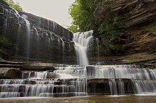
Cummins Falls is a waterfall on the Blackburn Fork River and is located in southern Jackson County, Tennessee. By volume, it is the eighth largest waterfall in Tennessee. The falls, with a total height of seventy-five feet, consist of two drops. The first has a plunge drop of fifty feet, ending in a shallow pool. The second has a cascade drop of twenty-five feet into a larger, deeper pool, or "swimming hole". In 2010, Cummins Falls was named "Tenth Best Swimming Hole in America" by Travel + Leisure magazine.
Cummins Falls State Park is a 282-acre (1.14 km2) state park located northwest of Cookeville in Jackson County in the U.S. state of Tennessee. Its namesake, Cummins Falls, is a 75-foot (23 m) waterfall, which is located on the Blackburn Fork State Scenic River. The park was purchased and created by the Tennessee Parks and Greenways Foundation in 2011.

State Route 53 (SR 53) is a north–south state highway that traverses six counties in Middle Tennessee. It is 113.5 miles (182.7 km) long.

State Route 477 (SR 477), also known as Cummins Mill Road, is a 5.4-mile-long (8.7 km) state highway in Jackson County, Tennessee. It connects SR 290 in Bloomington Springs with SR 135 near Dodson Branch, and it provides access to Cummins Falls State Park.

State Route 135 is a north–south secondary state highway located in eastern Middle Tennessee. it originates in White County along SR 289 on the north side of Sparta, and its northern end is in Clay County along SR 52. The total length is 61.5 miles (99.0 km) long, and is entirely a secondary state highway.
Spring Creek is a large stream in the U.S. state of Tennessee. It flows through Putnam, Overton and Jackson counties and is a major tributary of the Roaring River. It is part of the State Scenic River system of Tennessee, along with the Roaring River and Blackburn Fork River.
References
- ↑ "Cummins Falls State Park". Tennessee State Parks. Retrieved 17 June 2018.
- ↑ "Blackburn Fork". Tennessee State Government. Retrieved 17 June 2018.