Baxter, Tennessee

Last updated
Baxter, Tennessee
Baxter-RR-tracks-depot-tn1.jpg
Railroad tracks and Broad Street (right)
Flag of Baxter, Tennessee.svg
Putnam County Tennessee Incorporated and Unincorporated areas Baxter Highlighted 4703680.svg
Location of Baxter in Putnam County, Tennessee.
Coordinates: 36°9′18″N85°38′11″W / 36.15500°N 85.63639°W / 36.15500; -85.63639
Country United States
State Tennessee
County Putnam
Established1890s [1]
Incorporated 1915 [2]
Named for Jere Baxter [2]
Area
[3]
  Total3.15 sq mi (8.14 km2)
  Land3.15 sq mi (8.14 km2)
  Water0.00 sq mi (0.00 km2)
Elevation
[4]
1,027 ft (313 m)
Population
 (2020) [5]
  Total1,578
  Density501.75/sq mi (193.75/km2)
Time zone UTC-6 (Central (CST))
  Summer (DST) UTC-5 (CDT)
ZIP code
38544
Area code 931
FIPS code 47-03680 [6]
GNIS feature ID1304999 [4]
Website cityofbaxter.com

Baxter is a city in Putnam County, Tennessee, United States. The population was 1,578 at the 2020 census. [7] It is part of the Cookeville, Tennessee Micropolitan Statistical Area.

Contents

Geography

Baxter is located at 36°9′18″N85°38′11″W / 36.15500°N 85.63639°W / 36.15500; -85.63639 (36.155012, -85.636365). [8]

According to the United States Census Bureau, the city has a total area of 1.9 square miles (4.9 km2), all land.

Baxter was affected by the Tornado outbreak of March 2–3, 2020.

Demographics

Historical population
CensusPop.Note
1920 521
1930 5413.8%
1940 5766.5%
1950 86149.5%
1960 853−0.9%
1970 1,22944.1%
1980 1,41114.8%
1990 1,289−8.6%
2000 1,279−0.8%
2010 1,3656.7%
2020 1,57815.6%
Sources: [9] [10] [5]

2020 census

Baxter racial composition [11]
RaceNumberPercentage
White (non-Hispanic)1,43590.94%
Black or African American (non-Hispanic)211.33%
Native American 50.32%
Asian 50.32%
Other/Mixed 633.99%
Hispanic or Latino 493.11%

As of the 2020 United States census, there were 1,578 people, 584 households, and 372 families residing in the town.

2000 census

As of the census [6] of 2000, there were 1,279 people, 548 households, and 357 families residing in the city. The population density was 690.4 inhabitants per square mile (266.6/km2). There were 618 housing units at an average density of 333.6 per square mile (128.8/km2). The racial makeup of the city was 97.89% White, 0.70% Native American, 0.08% Pacific Islander, 0.47% from other races, and 0.86% from two or more races. Hispanic or Latino of any race were 1.72% of the population.

There were 548 households, out of which 28.6% had children under the age of 18 living with them, 51.5% were married couples living together, 10.8% had a female householder with no husband present, and 34.7% were non-families. 31.6% of all households were made up of individuals, and 15.5% had someone living alone who was 65 years of age or older. The average household size was 2.33 and the average family size was 2.94.

In the city, the population was spread out, with 24.5% under the age of 18, 7.8% from 18 to 24, 25.4% from 25 to 44, 24.6% from 45 to 64, and 17.7% who were 65 years of age or older. The median age was 40 years. For every 100 females, there were 89.5 males. For every 100 females age 18 and over, there were 81.6 males.

The median income for a household in the city was $25,078, and the median income for a family was $30,083. Males had a median income of $21,731 versus $19,118 for females. The per capita income for the city was $12,708. About 19.2% of families and 23.3% of the population were below the poverty line, including 28.2% of those under the age of 18 and 17.7% of those 65 and older.

Education

Baxter is served by the Putnam County School District with Upperman High School as the local high school.

Related Research Articles

<span class="mw-page-title-main">Putnam County, Tennessee</span> County in Tennessee, United States

Putnam County is a county located in the U.S. state of Tennessee. As of the 2020 census, the population was 79,854. Its county seat is Cookeville. Putnam County is part of the Cookeville, TN Micropolitan Statistical Area.

<span class="mw-page-title-main">Smith County, Tennessee</span> County in Tennessee, United States

Smith County is a county in the U.S. state of Tennessee. As of the 2020 census, the population was 19,904. Smith County is located in the region of the state known as Middle Tennessee. Its county seat is Carthage. The county was organized in 1799 and is named for Daniel Smith, a Revolutionary War veteran who made the first map of Tennessee and served as a United States senator.

<span class="mw-page-title-main">Jackson County, Tennessee</span> County in Tennessee, United States

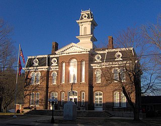
Jackson County is a county located in the U.S. state of Tennessee. The population was 11,617 at the 2020 census. Its county seat is Gainesboro. Jackson is part of the Cookeville Micropolitan Statistical Area.

<span class="mw-page-title-main">Sheffield, Alabama</span> City in Alabama, United States

Sheffield is a city in Colbert County, Alabama, United States, and is included in the Florence-Shoals metropolitan area. As of the 2010 census, the population of the city was 9,039. Sheffield is the birthplace of "country-soul pioneer" and songwriter Arthur Alexander, French horn player Willie Ruff, notable attorney, actor, former senator and presidential contender Fred Thompson, Watergate committee U.S. Senator Howell Heflin and U.S. Senator Mitch McConnell, whose father was working in nearby Athens when he was born. It sometimes is referred to as "the City of Senators" due to the births of Heflin, McConnell and Thompson within its borders. Col. Harland Sanders worked in the Sheffield depot for Southern Railway in the 1907. It is also home to the Muscle Shoals Sound Studio where many popular 20th century musicians recorded their work, including Alexander and Ruff. It is the site of historic Helen Keller Hospital, formerly known as Colbert County Hospital and originally constructed in 1921. It was changed to Helen Keller Hospital in 1979, and Keller's birthplace Ivy Green is located less than one mile southwest of the hospital in adjacent Tuscumbia.

<span class="mw-page-title-main">Gassville, Arkansas</span> City in Arkansas, United States

Gassville is a city in Baxter County, Arkansas, United States. According to the 2020 census, the city population was 2,171.

<span class="mw-page-title-main">Norfork, Arkansas</span> City in Arkansas, United States

Norfork is a city in Baxter County, Arkansas, United States. The population was 550 at the 2010 census.

<span class="mw-page-title-main">Salesville, Arkansas</span> City in Arkansas, United States

Salesville is a city in Baxter County, Arkansas, United States. The population was 450 in 2010.

<span class="mw-page-title-main">Bronson, Florida</span> Town in Florida, United States

Bronson is a town and the county seat of Levy County, Florida, United States. The population was 1,113 at the 2010 census.

<span class="mw-page-title-main">Elgin, Iowa</span> City in Iowa, United States

Elgin is a city in Fayette County, Iowa, United States. The population was 685 at the time of the 2020 census.

<span class="mw-page-title-main">Paxico, Kansas</span> City in Wabaunsee County, Kansas

Paxico is a city in Wabaunsee County, Kansas, United States. As of the 2020 census, the population of the city was 210.

<span class="mw-page-title-main">Reeder Township, Michigan</span> Civil township in Michigan, United States

Reeder Township is a civil township of Missaukee County in the U.S. state of Michigan. As of the 2020 census, the township population was 1,199.

<span class="mw-page-title-main">Hunter, Tennessee</span> CDP in Tennessee, United States

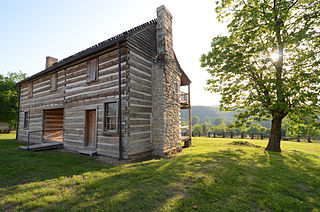
Hunter is a census-designated place (CDP) and unincorporated community located northeast of Elizabethton in Carter County, Tennessee, along Tennessee State Route 91 and the Watauga River. Its population was 1,854 as of the 2010 census. It is part of the Johnson City Metropolitan Statistical Area, which is a component of the Johnson City-Kingsport-Bristol, TN-VA Combined Statistical Area – commonly known as the "Tri-Cities" region. Hunter is a suburb of Elizabethton.

<span class="mw-page-title-main">Celina, Tennessee</span> City in Tennessee, United States

Celina is a city in and the county seat of Clay County, Tennessee, United States. The population was 1,495 at the 2010 census.

<span class="mw-page-title-main">Madisonville, Tennessee</span> City in Tennessee, United States

Madisonville is the county seat of Monroe County, Tennessee, United States. It is located in East Tennessee on the eastern border of the state. As of the 2020 census, the city's population was 5,132.

<span class="mw-page-title-main">Livingston, Tennessee</span> Town in Tennessee, United States

Livingston is a town in Overton County, Tennessee, United States, and serves as the county seat. The population was 3,905 at the 2020 census and 4,058 at the 2010 census. The current mayor, Curtis Hayes, began serving his mayoral position in September 2006.

<span class="mw-page-title-main">Monterey, Tennessee</span> Town in Tennessee, United States

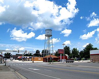
Monterey is a town in Putnam County, Tennessee, United States. The population was 2,850 at the 2010 census. It is part of the Cookeville, Tennessee Micropolitan Statistical Area.

<span class="mw-page-title-main">Gordonsville, Tennessee</span> Town in Tennessee, United States

Gordonsville is a town in Smith County, Tennessee, United States. The population was 1,213 at the 2010 census.

<span class="mw-page-title-main">Greenfield, Tennessee</span> City in Tennessee, United States

Greenfield is a city in northwestern Weakley County, Tennessee, United States. The population was 2,182 at the 2010 census and 2,078 in 2018.

<span class="mw-page-title-main">Petronila, Texas</span> City in Texas, United States

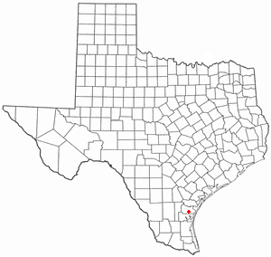
Petronila is a city in Nueces County, Texas, United States. The population of the city was 89 at the 2020 census.

<span class="mw-page-title-main">McKenzie, Tennessee</span> City in Tennessee, United States

McKenzie is a city at the tripoint of Carroll, Henry, and Weakley counties in Tennessee, United States. The population was 5,310 at the 2010 census.

References

  1. Solon Wayne Lowe, "History of Baxter Archived 2012-09-17 at the Wayback Machine ." Retrieved: 27 January 2013.
  2. 1 2 Larry Miller, Tennessee Place Names (Indiana University Press, 2001), p. 14.
  3. "ArcGIS REST Services Directory". United States Census Bureau. Retrieved October 15, 2022.
  4. 1 2 U.S. Geological Survey Geographic Names Information System: Baxter, Tennessee
  5. 1 2 "Census Population API". United States Census Bureau. Retrieved Oct 15, 2022.
  6. 1 2 "U.S. Census website". United States Census Bureau . Retrieved 2008-01-31.
  7. Tennessee Department of Economic and Community Development, Certified Population of Tennessee Incorporated Municipalities and Counties Archived 2014-06-30 at the Wayback Machine , State of Tennessee official website, 14 July 2011. Retrieved: 6 December 2013.
  8. "US Gazetteer files: 2010, 2000, and 1990". United States Census Bureau. 2011-02-12. Retrieved 2011-04-23.
  9. "Census of Population and Housing: Decennial Censuses". United States Census Bureau . Retrieved 2012-03-04.
  10. "Incorporated Places and Minor Civil Divisions Datasets: Subcounty Resident Population Estimates: April 1, 2010 to July 1, 2012". Population Estimates. U.S. Census Bureau. Archived from the original on 11 June 2013. Retrieved 11 December 2013.
  11. "Explore Census Data". data.census.gov. Retrieved 2021-12-27.