
The Tennessee River is a 652 mi (1,049 km) long river located in the southeastern United States in the Tennessee Valley. Flowing through the states of Tennessee, Alabama, Mississippi, Kentucky, it begins at the confluence of French Broad and Holston rivers at Knoxville, and drains into the Ohio River near Paducah, Kentucky. It is the largest tributary of the Ohio, and drains a basin of 40,876 sq mi (105,870 km2).

The Cumberland River is a major waterway of the Southern United States. The 688-mile-long (1,107 km) river drains almost 18,000 square miles (47,000 km2) of southern Kentucky and north-central Tennessee. The river flows generally west from a source in the Appalachian Mountains to its confluence with the Ohio River near Paducah, Kentucky, and the mouth of the Tennessee River. Major tributaries include the Obey, Caney Fork, Stones, and Red Rivers.

The French Broad River is a river in the U.S. states of North Carolina and Tennessee. It flows 218 miles (351 km) from near the town of Rosman in Transylvania County, North Carolina, into Tennessee, where its confluence with the Holston River at Knoxville forms the beginning of the Tennessee River. The river flows through the counties of Transylvania, Buncombe, Henderson, and Madison in North Carolina, and Cocke, Jefferson, Sevier, and Knox in Tennessee. It drains large portions of the Pisgah National Forest and the Cherokee National Forest.

The Holston River is a 136-mile (219 km) river that flows from Kingsport, Tennessee, to Knoxville, Tennessee. Along with its three major forks, it comprises a major river system that drains much of northeastern Tennessee, southwestern Virginia, and northwestern North Carolina. The Holston's confluence with the French Broad River at Knoxville marks the beginning of the Tennessee River.
The Clarks River, named for William Clark of the 1804-1806 Lewis and Clark Expedition, is a 66.7-mile-long (107.3 km) tributary of the Tennessee River in the Jackson Purchase region of western Kentucky. Below the West Fork Clarks River, the river has a mean annual discharge of 368 cubic feet per second. This figure is obtained by combining the average discharge of the Clarks River at Benton, and the average discharge of the West Fork at Brewers.
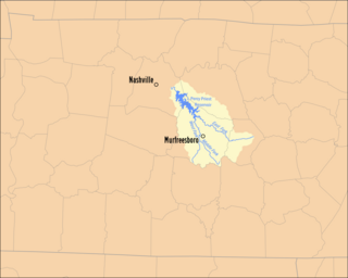
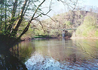
The Stones River is a major stream of the eastern portion of Tennessee's Nashville Basin region and a tributary of the Cumberland River. It is named after explorer and longhunter Uriah Stone, who navigated the river in 1767.

The Red River, 100 miles (161 km) long, is a major stream of north-central Tennessee and south-central Kentucky, and a major tributary of the Cumberland River.

The Watauga River is a large stream of western North Carolina and East Tennessee. It is 78.5 miles (126.3 km) long with its headwaters in Linville Gap to the South Fork Holston River at Boone Lake.

The Big South Fork of the Cumberland River is a 76-mile-long (122 km) river in the U.S. states of Tennessee and Kentucky. It is a major drainage feature of the Cumberland Plateau, a major tributary of the Cumberland River system, and the major feature of the Big South Fork National River and Recreation Area.

The Caney Fork River is a river that flows through central Tennessee in the United States, draining a substantial portion of the southwestern Cumberland Plateau and southeastern Highland Rim regions. It is a major tributary of the Cumberland River, and is part of the Cumberland, Ohio and Mississippi basins. The river is 143 miles (230 km) long, and its watershed covers 1,771 square miles (4,590 km2) in eleven counties. Monterey, Baxter, Sparta, Smithville, McMinnville, Altamont, Spencer and Gordonsville are among the towns that are at least partially drained by the river.
The Powell River is a 195-mile-long river in the United States that rises in Southwest Virginia and flows southwest into East Tennessee.

State Route 91 is a primary state highway in the U.S. state of Virginia. The state highway runs 55.12 miles (88.71 km) from the Tennessee state line near Damascus, where the highway continues as Tennessee State Route 91, north to U.S. Route 19 Business and US 460 Business at Frog Level. SR 91 connects Damascus in southeastern Washington County with the northeastern county town Glade Spring, where the highway has junctions with US 11 and Interstate 81 (I-81). The state highway also indirectly connects Saltville in northwestern Smyth County and Tazewell, the county seat of Tazewell County. SR 91 is the only primary state highway in Virginia with an unpaved section; this gravel section is in southern Tazewell County.
The Clear Fork is a 42.8-mile-long (68.9 km) tributary of the Cumberland River in Kentucky and Tennessee. By the Cumberland and Ohio rivers, it is part of the Mississippi River watershed.
The South Fork of the Forked Deer River is formed at the confluence of Huggins Creek and Tar Creek in the southern part of Chester County, Tennessee, United States. It flows in a generally northern direction and passes just to the east of Henderson. It then runs in a northwesterly direction and enters Madison County and passes near Pinson. Flowing still generally north it passes through Jackson. It continues across Madison County and enters Crockett County, It flows in a northwest direction through the following counties sometimes passing in and out of a county several times. Haywood County, Lauderdale County and Dyer County where it joins with the North Fork. The Forked Deer then empties into the Obion River which in turn flows into the Mississippi River.
The North Fork of the Forked Deer River is formed in Gibson County to the south of Chapel Hill Road near Medina and flows to the northwest before entering Dyer County. Here it accepts the flow from the Middle Fork and then joins with the South Fork to form the Forked Deer River.
The Smith Fork Creek is a large stream that flows through Middle Tennessee in the United States, draining much of the southwestern Upper Cumberland region. It is a major tributary of the Caney Fork River, and is part of the Cumberland, Ohio and Mississippi basins. The creek is approximately 39 to 40 miles long, and its watershed covers parts of four counties as a subset of the Caney Fork watershed. The small towns and communities of Statesville, Auburntown, Gassaway, Liberty, Dowelltown, Temperance Hall, and Lancaster are drained by the creek, which empties into the Caney Fork 4.1 miles (6.6 km) southeast of Gordonsville.
Indian Creek, also known as Big Indian Creek, is a large stream in western Putnam County, Tennessee. It is a tributary of the Caney Fork River.
Short Mountain is a mountain-sized monadnock that is the highest point in Cannon County, Tennessee and the Nashville metropolitan area. It is surrounded by the Highland Rim to the north, east and south but is an outlier of the Cumberland Plateau, evidenced by its sandstone caprock reaching over 2,000 feet in elevation; this makes it the westernmost part of Tennessee with an elevation over 2,000 feet. Nearby Little Short Mountain to the east and Sugar Tree Knob to the west also stand well over 1,400 feet above sea level, and Little Short Mountain is even still high enough above nearby river valleys in the Nashville Basin to qualify as a Class 6 mountain, but they don't have sandstone caprock nor reach the height Short Mountain does.
