
Carter County is a county located in the U.S. state of Tennessee. As of the 2020 census, the population was 56,356. Its county seat is Elizabethton. The county is named in honor of Landon Carter (1760-1800), an early settler active in the "Lost State of Franklin" 1784-1788 secession from the State of North Carolina. Carter County is part of the Johnson City, TN Metropolitan Statistical Area, which is a component of the Johnson City–Kingsport–Bristol, TN-VA Combined Statistical Area, located in northeastern Tennessee.

Watauga County is a county located in the U.S. state of North Carolina. As of the 2020 census, the population was 54,086. Its county seat and largest community is Boone. The county is in an exceptionally mountainous region, known as the High Country. It is the home of Appalachian State University, which has approximately 20,023 students as of August 2020. Watauga County comprises the Boone, NC Micropolitan Statistical Area.

Elizabethton is a city in, and the county seat of Carter County, Tennessee, United States. Elizabethton is the historical site of the first independent American government located west of both the Eastern Continental Divide and the original Thirteen Colonies.

Roan Mountain is a census-designated place (CDP) in Carter County, Tennessee, United States. The population was 1,360 at the 2010 census. It is part of the Johnson City Metropolitan Statistical Area, which is a component of the Johnson City–Kingsport–Bristol, TN-VA Combined Statistical Area – commonly known as the Tri-Cities region.
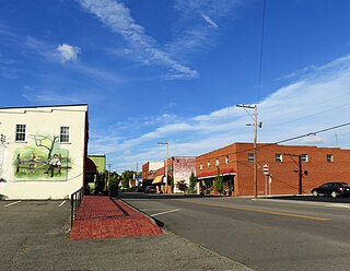
Mountain City is a town in and the county seat of Johnson County, Tennessee, United States. The population was 2,415 at the 2020 census. It is the northeasternmost county seat in Tennessee. In addition, at an elevation of 2,418 feet (737 m), it has the distinction of being the highest incorporated city in the state.

The Watauga River is a large stream of western North Carolina and East Tennessee. It is 78.5 miles (126.3 km) long with its headwaters in Linville Gap to the South Fork Holston River at Boone Lake.

The Doe River is a tributary of the Watauga River in northeast Tennessee in the United States. The river forms in Carter County near the North Carolina line, just south of Roan Mountain State Park, and flows to Elizabethton.

The Nolichucky River is a 115-mile (185 km) river that flows through western North Carolina and East Tennessee in the southeastern United States. Traversing the Pisgah National Forest and the Cherokee National Forest in the Blue Ridge Mountains, the river's watershed includes some of the highest mountains in the Appalachians, including Mount Mitchell in North Carolina, the highest point in the eastern United States. The river is a tributary of the French Broad River and is impounded by Nolichucky Dam near Greeneville, Tennessee.

The Tennessee Valley is the drainage basin of the Tennessee River and is largely within the U.S. state of Tennessee. It stretches from southwest Kentucky to north Alabama and from northeast Mississippi to the mountains of Virginia and North Carolina. The border of the valley is known as the Tennessee Valley Divide. The Tennessee Valley contributes greatly to the formation of Tennessee's three legally recognized sectors.
The East Tennessee & Western North Carolina Railroad, affectionately called the "Tweetsie" as a verbal acronym of its initials (ET&WNC) but also in reference to the sound of its steam whistles, was a primarily 3 ft narrow gauge railroad established in 1866 for the purpose of serving the mines at Cranberry, North Carolina.

The Overmountain Victory National Historic Trail (OVHT) is part of the U.S. National Trails System, and N.C. State Trail System. It recognizes the Revolutionary War Overmountain Men, Patriots from what is now East Tennessee who crossed the Unaka Mountains and then fought in the Battle of Kings Mountain in South Carolina.

The Sycamore Shoals of the Watauga River, usually shortened to Sycamore Shoals, is a rocky stretch of river rapids along the Watauga River in Elizabethton, Tennessee. Archeological excavations have found Native Americans lived near the shoals since prehistoric times, and Cherokees gathered there. As Europeans began settling the Trans-Appalachian frontier, the shoals proved strategic militarily, as well as shaped the economies of Tennessee and Kentucky. Today, the shoals are protected as a National Historic Landmark and are maintained as part of Sycamore Shoals State Historic Park.

The Laurel Fork Railway was a small, standard-gauge logging railroad that operated entirely in Carter County, Tennessee from 1912 to 1927. Built by the Pittsburgh Lumber Company to serve a double-band sawmill at Braemar, in present-day Hampton, Tennessee.
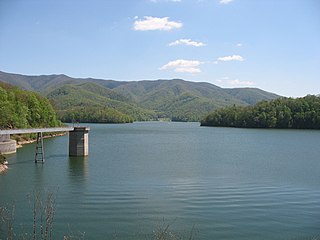
Watauga Lake, located east of Elizabethton, Tennessee, is the local name of the Watauga Reservoir created by the Tennessee Valley Authority (TVA) with the 1948 completion of the TVA Watauga Dam.

Sycamore Shoals State Historic Area is a state park located in Elizabethton, in the U.S. state of Tennessee. The park consists of 70 acres (28.3 ha) situated along the Sycamore Shoals of the Watauga River, a National Historic Landmark where a series of events critical to the establishment of the states of Tennessee and Kentucky, and the settlement of the Trans-Appalachian frontier in general, took place. Along with the historic shoals, the park includes a visitor center and museum, the reconstructed Fort Watauga, the Carter House and Sabine Hill . For over a thousand years before the arrival of European explorers, Sycamore Shoals and adjacent lands had been inhabited by Native Americans. The first permanent European settlers arrived in 1770, and established the Watauga Association—one of the first written constitutional governments west of the Appalachian Mountains—in 1772. Richard Henderson and Daniel Boone negotiated the Treaty of Sycamore Shoals in 1775, which saw the sale of millions of acres of Cherokee lands in Kentucky and Tennessee and led to the building of the Wilderness Road. During the American Revolution, Sycamore Shoals was both the site of Fort Watauga, where part of a Cherokee invasion was thwarted in 1776, and the mustering ground for the Overmountain Men in 1780.

The Elizabethton Covered Bridge is a 134-foot (41 m) covered bridge over the Doe River in Elizabethton, the county seat of Carter County, Tennessee.

State Route 67 is a state-maintained highway in northeastern Tennessee, including a four-lane divided highway segments in both Washington County and Carter County, and part of a significant two-lane segment passing over the Butler Bridge some 80 feet (24 m) above the TVA Watauga Reservoir near Butler in Johnson County, Tennessee.
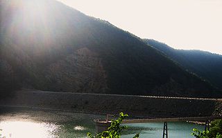
Watauga Dam is a hydroelectric and flood control dam on the Watauga River in Carter County, in the U.S. state of Tennessee. It is owned and operated by the Tennessee Valley Authority, which built the dam in the 1940s as part of efforts to control flooding in the Tennessee River watershed. At 318 feet (97 m), Watauga is the second-highest dam in the TVA river and reservoir system, and at the time of its completion was one of the highest earth-and-rock dams in the United States. The dam impounds the TVA Watauga Reservoir of 6,430 acres (2,600 ha), and its tailwaters feed into Wilbur Lake.

State Route 91 is a state highway in the northeastern portion of the U.S. state of Tennessee, in the area known as the Tri-Cities region. The route connects Johnson City with Damascus, Virginia via Elizabethton, Hunter, and Mountain City.
Beaverdam Creek (conservation area), a wildland in the George Washington and Jefferson National Forests of western Virginia and the Cherokee National Forest of eastern Tennessee, has been recognized by the Wilderness Society as a special place worthy of protection from logging and road construction. The Wilderness Society has designated the area as a "Mountain Treasure".


