
The Tennessee River is a 652 mi (1,049 km) long river located in the southeastern United States in the Tennessee Valley. Flowing through the states of Tennessee, Alabama, Mississippi, Kentucky, it begins at the confluence of French Broad and Holston rivers at Knoxville, and drains into the Ohio River near Paducah, Kentucky. It is the largest tributary of the Ohio, and drains a basin of 40,876 sq mi (105,870 km2).

The Stillwater River is a 69.3-mile-long (111.5 km) tributary of the Great Miami River in western Ohio in the United States. Via the Great Miami and Ohio rivers, it is part of the Mississippi River watershed.

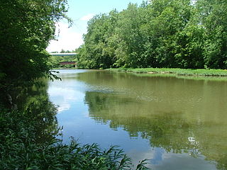
The Little Miami River is a Class I tributary of the Ohio River that flows 111 miles (179 km) through five counties in southwestern Ohio in the United States. The Little Miami joins the Ohio River east of Cincinnati. It forms parts of the borders between Hamilton and Clermont counties and between Hamilton and Warren counties. The Little Miami River is one of 156 American rivers designated by the U.S. Congress or the Secretary of the Interior as a National Wild and Scenic River and lends its name to the adjacent Little Miami Scenic Trail.

New York State Route 28 (NY 28) is a state highway extending for 281.69 miles (453.34 km) in the shape of a "C" between the Hudson Valley city of Kingston and southern Warren County in the U.S. state of New York. Along the way, it intersects several major routes, including Interstate 88 (I-88), U.S. Route 20 (US 20), and the New York State Thruway twice. The southern terminus of NY 28 is at NY 32 in Kingston and the northern terminus is at US 9 in Warrensburg. In Kingston, NY 28 is co-designated as Interstate 587 from its southern terminus at NY 32 to the roundabout linking it to the Thruway (I-87).

The Clear Fork is a 27.2-mile-long (43.8 km) stream draining part of the Cumberland Plateau of Tennessee, United States. It is a tributary of the Big South Fork of the Cumberland River. By that river, the Cumberland River, and the Ohio River, it is part of the Mississippi River watershed.

The Piney River is a stream that drains a portion of Tennessee's Cumberland Plateau generally known as Walden Ridge. The Piney River rises near the Rhea County – Bledsoe County line and is referred to as Piney Creek in its upper reaches roughly until its confluence with Duskin Creek. Its major tributary, Little Piney Creek, flows over two spectacular waterfalls which are located in Piney Falls State Natural Area near the community of Grandview. A tributary of Little Piney Creek is Soak Creek, Tennessee's newest State Scenic River. The confluence of the two streams occurs below the falls of the smaller stream in an area referred to as "Shut-in Gap". The stream flows out of the gap and is bridged by State Route 68 just before that road begins its steep climb up the Cumberland Escarpment onto Waldens Ridge. The stream flows north of Spring City, Tennessee and becomes slack just east of the town at a headland of Watts Bar Lake, an impoundment of the Tennessee River formed by the Tennessee Valley Authority's Watts Bar Dam project. The mouth of the Piney is one of the larger bays of Watts Bar Lake and contains several small islands.
Paint Creek is a tributary of the Scioto River, 94.7 miles (152.4 km) long, in south-central Ohio in the United States. Via the Scioto and Ohio Rivers, it is part of the watershed of the Mississippi River. It drains an area of 1,143 square miles (2,960 km2).

Alum Creek is a 58-mile (93 km) long creek that runs north to south in central Ohio. The creek originates in Morrow County and then flows through Delaware County and finally into Franklin County, where it ends at Big Walnut Creek, which drains into the Scioto River. Alum Creek is a source of drinking water for the city of Westerville, Ohio.

Moxahala Creek is a tributary of the Muskingum River, 29.2 miles (47.0 km) long, in southeastern Ohio in the United States. Via the Muskingum and Ohio Rivers, it is part of the watershed of the Mississippi River, draining an area of 301 square miles (780 km2)

New York State Route 23 (NY 23) is an east–west state highway in the eastern portion of New York in the United States. It extends for 156.15 miles (251.30 km) from an intersection with NY 26 in the Central New York town of Cincinnatus in Cortland County to the Massachusetts state line in the Berkshire Mountains, where it continues east as that state's Route 23. Along the way, it passes through many communities, including the cities of Norwich and Oneonta. Outside of the communities, the route serves largely rural areas of the state and traverses the Catskill Mountains in the state's Central New York Region. NY 23 crosses the Hudson River at Catskill via the Rip Van Winkle Bridge.

New York State Route 328 (NY 328) is a northeast–southwest state highway located entirely within the town of Southport in Chemung County, New York, in the United States. The northeast end of NY 328 is at an intersection with NY 14 in the community of Southport, and the southwest terminus is at the Pennsylvania state line, where NY 328 continues on as Pennsylvania Route 328 (PA 328). NY 328 parallels Seeley Creek, a tributary of the Chemung River, for its entire length. The entirety of the 6.15-mile (9.90 km) route is part of Corridor U of the Appalachian Development Highway System.

New York State Route 268 (NY 268) is a state highway located in southwestern Delaware County, New York, in the United States. It runs from NY 97 in Hancock north over 10 miles (16 km) to a bridge over Cannonsville Reservoir near the former site of the hamlet of Rock Rift in Tompkins. There, it ends at a junction with NY 10. NY 268 meets the Quickway (NY 17) east of the Hancock village limits.

New York State Route 28N (NY 28N) is an east–west state highway in the North Country of New York in the United States. It extends for 50.95 miles (82.00 km) through the Adirondack Mountains from Blue Mountain Lake to North Creek. The route is a northerly alternate route to NY 28 between both locations; as such, it passes through several communities that NY 28 bypasses to the south. The westernmost 10 miles (16 km) of NY 28N overlap with NY 30 through the town of Long Lake. NY 28N and NY 30 split in the hamlet of Long Lake, from where NY 30 heads to the north and NY 28N proceeds eastward through mountainous regions of Adirondack Park.
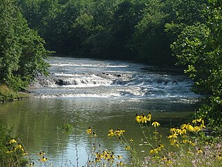
Greenville Creek is a 44.4-mile-long (71.5 km) tributary of the Stillwater River in southwestern Ohio in the United States. Via the Stillwater River, the Great Miami River, and the Ohio River, its water flows to the Mississippi River and ultimately the Gulf of Mexico. The creek starts in extreme eastern Indiana in Randolph County. It soon flows into Darke County, Ohio, and joins with a tributary that also starts in Indiana, Dismal Creek. It flows through Greenville and Gettysburg before entering Miami County. Near its confluence with the Stillwater River at Covington it drops 20 feet (6.1 m) at Greenville Falls in a glacially-cut gorge that is a state nature preserve.

Elkhorn Creek is a 7.6-mile (12 km) long stream in Marion County, Oregon, United States. Its source is on the northern edge of the Willamette National Forest, about 3.5 miles (5.6 km) north of Big Cliff Reservoir. The creek flows mostly west, receiving Big Twelve Creek, Buckhorn Creek, and Buck Creek all from the south, and it enters the Little North Santiam River just south of Elkhorn Woods Park, about 5 miles (8.0 km) north of the city of Gates. The stream's valley is surrounded by the western Cascade foothills, covered with coniferous trees characteristic of the Pacific Northwest, and lined with red alders at the water's edge. The creek supports runs of rainbow and coastal cutthroat trout, as well as Pacific giant salamanders. On September 30, 1996, a 6.4-mile (10.3 km) portion of the stream, from the mouth nearly to the source, was protected as part of the National Wild and Scenic Rivers System.
Winding Gulf is a 15.5-mile (24.9 km) long tributary of the Guyandotte River in Raleigh County, West Virginia. Winding Gulf is part of the Mississippi River watershed via the Guyandotte and Ohio Rivers, and drains an area of 21.63 square miles (56.0 km2) in a rural area on the Allegheny Plateau.
Foster Coulee is a coulee in Douglas County, Washington. Like the larger Moses Coulee nearby, it was formed during the Missoula Floods at the end of the last ice age, some 14,000 years ago.
The Verkeerder Kill, sometimes Verkeerderkill and locally shortened to Kaidy Kill is an 8-mile-long (13 km) stream in Ulster County, New York, United States. It rises on the Shawangunk Ridge, in the town of Wawarsing, and flows southwards through the town of Shawangunk, toward the Shawangunk Kill, itself a major tributary of the Wallkill River. Ultimately it is a part of the Hudson River's watershed.

The Canajoharie Creek is a river that flows into the Mohawk River in the Village of Canajoharie in the U.S. State of New York. The name "Canajoharie" is a Mohawk language term meaning "the pot that washes itself", referring to the "Canajoharie Boiling Pot", a 20-foot (6.1 m) wide and 10-foot (3.0 m) deep pothole in the Canajoharie Creek, just south of the village of Canajoharie. Bowmans Creek is one main tributary that enters the creek east of the Hamlet of Sprout Brook. The other main tributary is Brimstone Creek which enters the creek north-northwest of the Village of Ames.
The Saw Kill is a 14.3-mile-long (23.0 km) tributary of the Hudson River, called the Metambesem by the Algonquin people of the area and sometimes called Sawkill Creek today. It rises in the town of Milan and drains a 22-square-mile (57 km2) area of northwestern Dutchess County, New York, that includes most of the town of Red Hook to the west and part of Rhinebeck to Red Hook's south.
