Butler, Tennessee

Last updated

Butler
Butler-McQueen-Street-tn1.jpg
Buildings along McQueen Street
USA Tennessee location map.svg
Red pog.svg
Butler
Usa edcp location map.svg
Red pog.svg
Butler
Coordinates: 36°21′12″N82°01′56″W / 36.35333°N 82.03222°W / 36.35333; -82.03222
Country Flag of the United States (23px).png  United States
State Flag of Tennessee.svg  Tennessee
County Johnson County
Area
[1]
  Total0.78 sq mi (2.02 km2)
  Land0.76 sq mi (1.98 km2)
  Water0.02 sq mi (0.05 km2)
Elevation
1,995 ft (608 m)
Population
 (2020) [2]
  Total297
  Density389.25/sq mi (150.34/km2)
Time zone UTC-5 (Eastern (EST))
  Summer (DST) UTC-4 (EDT)
ZIP code
37640
Area code 423
FIPS code 47-10080
GNIS feature ID1305567 [3]

Butler is an unincorporated community in Johnson County in the northeastern corner of the U.S. state of Tennessee. It is located along the northern shore of Watauga Lake. [4] Butler is served by a post office, assigned ZIP Code 37640.

Contents

Demographics

Historical population
CensusPop.Note
2020 297
U.S. Decennial Census [5]

History

The town was originally located on Roan Creek [6] at its confluence with the Watauga River. [7] Settlement began in 1768. [7] For many years the community was called Smith's Mill for the gristmill that Ezekial “Zeke” Smith built on the bank of Roan Creek in 1820. [8] After the Civil War, it was renamed in honor of Colonel Roderick R. Butler of Johnson County, who then represented the area in the state legislature and had been a commander in the 13th Tennessee Cavalry in the Union Army. [9]

Aenon Seminary, a secondary school, was established in Butler in 1871. [8] It later became Holly Spring College, [8] offering education up to a bachelor's degree, and enrolling as many as 200 students. [7] In 1906 it was purchased by the Watauga Baptist Association, which renamed it Watauga Academy. It operated under that name until 1948, when the town was inundated by the formation of Watauga Lake. [10]

Butler was the birthplace of U.S. Congressmen B. Carroll Reece of Tennessee and Robert R. Butler of Oregon (grandson of the town's namesake).

Inundation and relocation

Main Street in "old" Butler, before inundation Old-butler-mainst-tn1.jpg
Main Street in "old" Butler, before inundation

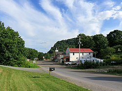
The original town of Butler was subject to frequent flooding, experiencing major floods in 1867, 1886, 1901, 1902, 1916, 1924, and 1940. [11] The Tennessee Valley Authority (TVA) began the construction of the Watauga Dam in 1942 which created the Watauga Lake. The construction was delayed because of the ongoing World War II, but was finished in 1948 when the water steadily began rising and the town slowly became submerged under the lake. Butler was the only incorporated town inundated by a TVA reservoir. [12] In 1948, before the reservoir was filled, the town, which at the time had a population of about 600 and included more than 125 homes and 50 businesses, was relocated to higher ground. [6] [8] [9] [12] The relocation project required construction of 54.9 miles (88.4 km) of roads and highways, three bridges, and 66 miles (106 km) of utility lines, as well as relocation of 1,281 graves. [13] The town's new site is located on Tennessee State Route 67 at 36°21′25″N82°01′49″W / 36.35682°N 82.03015°W / 36.35682; -82.03015 .

The original town is now known as "Old Butler." [14] Old Butler, called “the town that wouldn’t drown,” is commemorated in a museum in Butler and by "Old Butler Days" which is an annual festival held each year in August right in the heart of the town. [15] In 1983, a drawdown of the lake exposed the remains of Old Butler for a brief time, allowing former residents to visit the site. [12] [16]

Related Research Articles

<span class="mw-page-title-main">Washington County, Tennessee</span> County in Tennessee, United States

Washington County is a county located in the U.S. state of Tennessee. As of the 2020 census, the population was 133,001. Its county seat is Jonesborough. The county's largest city and a regional educational, medical and commercial center is Johnson City. Washington County is Tennessee's oldest county, having been established in 1777 when the state was still part of North Carolina. Washington County is part of the Johnson City, TN Metropolitan Statistical Area, which is a component of the Johnson City–Kingsport–Bristol, TN-VA Combined Statistical Area, commonly known as the "Tri-Cities" region.

<span class="mw-page-title-main">Union County, Tennessee</span> County in Tennessee, United States

Union County is a county located in the U.S. state of Tennessee. As of the 2020 census, its population was 19,802. Its county seat is Maynardville. Union County is included in the Knoxville metropolitan statistical area.

<span class="mw-page-title-main">Carter County, Tennessee</span> County in Tennessee, United States

Carter County is a county located in the U.S. state of Tennessee. As of the 2020 census, the population was 56,356. Its county seat is Elizabethton. The county is named in honor of Landon Carter (1760-1800), an early settler active in the "Lost State of Franklin" 1784-1788 secession from the State of North Carolina. Carter County is part of the Johnson City, TN Metropolitan Statistical Area, which is a component of the Johnson City–Kingsport–Bristol, TN-VA Combined Statistical Area, located in northeastern Tennessee.

<span class="mw-page-title-main">Elizabethton, Tennessee</span> City in Tennessee, United States

Elizabethton is a city in, and the county seat of Carter County, Tennessee, United States. Elizabethton is the historical site of the first independent American government located west of both the Eastern Continental Divide and the original Thirteen Colonies.

<span class="mw-page-title-main">Roan Mountain, Tennessee</span> CDP in Tennessee, United States

Roan Mountain is a census-designated place (CDP) in Carter County, Tennessee, United States. The population was 1,360 at the 2010 census. It is part of the Johnson City Metropolitan Statistical Area, which is a component of the Johnson City–Kingsport–Bristol, TN-VA Combined Statistical Area – commonly known as the Tri-Cities region.

<span class="mw-page-title-main">Mountain City, Tennessee</span> Town in Tennessee, United States

Mountain City is a town in and the county seat of Johnson County, Tennessee, United States. The population was 2,415 at the 2020 census. It is the northeasternmost county seat in Tennessee. In addition, at an elevation of 2,418 feet (737 m), it has the distinction of being the highest incorporated city in the state.

<span class="mw-page-title-main">Watauga, Tennessee</span> City in Tennessee, United States

Watauga is a city in Carter and Washington counties in the U.S. state of Tennessee. The population was 403 at the 2000 census, 458 at the 2010 census, 361 in the 2020 census. It is part of the Johnson City Metropolitan Statistical Area, which is a component of the Johnson City-Kingsport-Bristol, TN-VA Combined Statistical Area – commonly known as the "Tri-Cities" region.

<span class="mw-page-title-main">Tri-Cities, Tennessee</span> Region in East Tennessee

The Tri-Cities is the region comprising the cities of Kingsport, Johnson City, and Bristol and the surrounding smaller towns and communities in Northeast Tennessee and Southwest Virginia. All three cities are located in Northeast Tennessee, while Bristol has a twin city of the same name in Virginia.

<span class="mw-page-title-main">East Tennessee</span> Geographic region of Tennessee

East Tennessee is one of the three Grand Divisions of Tennessee defined in state law. Geographically and socioculturally distinct, it comprises approximately the eastern third of the U.S. state of Tennessee. East Tennessee consists of 33 counties, 30 located within the Eastern Time Zone and three counties in the Central Time Zone, namely Bledsoe, Cumberland, and Marion. East Tennessee is entirely located within the Appalachian Mountains, although the landforms range from densely forested 6,000-foot (1,800 m) mountains to broad river valleys. The region contains the major cities of Knoxville and Chattanooga, Tennessee's third and fourth largest cities, respectively, and the Tri-Cities, the state's sixth largest population center.

<span class="mw-page-title-main">Watauga River</span> River in the United States of America

The Watauga River is a large stream of western North Carolina and East Tennessee. It is 78.5 miles (126.3 km) long with its headwaters in Linville Gap to the South Fork Holston River at Boone Lake.

<span class="mw-page-title-main">Bean Station, Tennessee</span> Lakeside town in Grainger and Hawkins counties, Tennessee

Bean Station is a town in Grainger and Hawkins of Tennessee, United States. As of the 2020 census, the population was 2,967. It is part of the Kingsport, Knoxville, and Morristown metropolitan statistical areas.

<span class="mw-page-title-main">Roderick R. Butler</span> American politician (1827–1902)

Roderick Randum Butler was an American politician who represented Tennessee's 1st district in the United States House of Representatives from 1867 to 1875, and again from 1887 to 1889. He also served several terms in the Tennessee state legislature, and briefly served as a state court judge. An opponent of secession, Butler represented Johnson County at the East Tennessee Convention in 1861, and afterward joined the Union Army. Butler was censured by the House of Representatives in March 1870 for receiving payment in return for recommending someone for admission to the U.S. Naval Academy.

<span class="mw-page-title-main">Watauga Lake</span> Reservoir in Tennessee, United States

Watauga Lake, located east of Elizabethton, Tennessee, is the local name of the Watauga Reservoir created by the Tennessee Valley Authority (TVA) with the 1948 completion of the TVA Watauga Dam.

<span class="mw-page-title-main">Bee Cliff (Tennessee)</span>

The Bee Cliff is a prominent northeast Tennessee geological limestone feature with high caves that overlooks the Watauga River and the Siam community of Carter County, Tennessee.

<span class="mw-page-title-main">Hampton, Tennessee</span> CDP in Tennessee, United States

Hampton is an unincorporated community and Census-designated place in Carter County, Tennessee, United States. Located a few miles southeast of Elizabethton and northwest of Roan Mountain, Hampton is surrounded on all sides by the Unaka Mountains. It is part of the Johnson City Metropolitan Statistical Area, which is a component of the Johnson City–Kingsport–Bristol, TN-VA Combined Statistical Area – commonly known as the "Tri-Cities" region.

<span class="mw-page-title-main">Loyston, Tennessee</span> Ghost town in Tennessee, United States

Loyston is a ghost town in Union County, Tennessee, United States, that was inundated by the waters of the Clinch River after the completion of Norris Dam in 1936. Established in the early 19th century around a foundry built by its namesake, John Loy, over subsequent decades the community's location along State Highway 61 helped it grow into a trading center for local farmers. By the time the Tennessee Valley Authority (TVA) began making plans to build Norris Dam in the early 1930s, Loyston had a population of approximately 70 residents, and consisted of a post office and several small businesses.

<span class="mw-page-title-main">Tennessee State Route 67</span> Highway in Tennessee

State Route 67 is a state-maintained highway in northeastern Tennessee, including a four-lane divided highway segments in both Washington County and Carter County, and part of a significant two-lane segment passing over the Butler Bridge some 80 feet (24 m) above the TVA Watauga Reservoir near Butler in Johnson County, Tennessee.

<span class="mw-page-title-main">Watauga Dam</span> Dam in Tennessee, United States

Watauga Dam is a hydroelectric and flood control dam on the Watauga River in Carter County, in the U.S. state of Tennessee. It is owned and operated by the Tennessee Valley Authority, which built the dam in the 1940s as part of efforts to control flooding in the Tennessee River watershed. At 318 feet (97 m), Watauga is the second-highest dam in the TVA river and reservoir system, and at the time of its completion was one of the highest earth-and-rock dams in the United States. The dam impounds the TVA Watauga Reservoir of 6,430 acres (2,600 ha), and its tailwaters feed into Wilbur Lake.

The Johnson City Metropolitan Statistical Area, as defined by the United States Census Bureau, is an area consisting of three counties in East Tennessee, anchored by the city of Johnson City. As of the 2020 census, the MSA had a population of 207,285.

<span class="mw-page-title-main">Doeville, Tennessee</span> Unincorporated community in Tennessee, US

Doeville is an unincorporated community in Johnson County, Tennessee. It is concentrated around the intersection of Tennessee State Route 67 and Tennessee State Route 167, west of Mountain City and east of Butler. The community of Pandora lies immediately to the northeast along S.R. 67.

References

  1. "ArcGIS REST Services Directory". United States Census Bureau. Retrieved October 15, 2022.
  2. "Census Population API". United States Census Bureau. Retrieved October 15, 2022.
  3. "Butler, Tennessee". Geographic Names Information System . United States Geological Survey, United States Department of the Interior . Retrieved April 27, 2013.
  4. Johnson County, Tennessee General Highway Map (PDF) (Map). Tennessee Department of Transportation. 2003. Archived from the original (PDF) on July 13, 2013. Retrieved April 28, 2013.
  5. "Census of Population and Housing". Census.gov. Retrieved June 4, 2016.
  6. 1 2 Places of Johnson County TN Archived October 11, 2007, at the Wayback Machine , Johnson County TNGenWeb
  7. 1 2 3 Herman Tester (2006) Butler: Old, New and Carderview. ISBN   0-615-15467-0
  8. 1 2 3 4 Book description for Old Butler (TN) (Images of America), by Michael and Lanette Depew, Amazon.com
  9. 1 2 Butler, Tennessee: Colonel Roderick Random Butler's Namesake, WataugaLakeMagazine.com, September 2007
  10. Schools [ permanent dead link ], in The History of Johnson County, Mountain City Elementary School website, accessed March 21, 2008
  11. Butler Museum Archived April 15, 2008, at the Wayback Machine , Tennessee History for Kids website (accessed March 22, 2008)
  12. 1 2 3 Immersed Remains: Towns Submerged In America Archived March 4, 2008, at the Wayback Machine , The Lay of the Land, volume 28, Spring 2005, Center for Land Use Interpretation
  13. The Town of Butler, in The History of Johnson County, Mountain City Elementary School website, accessed March 21, 2008
  14. Old Butler Days, WataugaLakeMagazine.com, August 2007
  15. Lois Carol Wheatley, Dive Into Old Butler Days August 10 to 11 Archived September 19, 2008, at the Wayback Machine , High Country Press (Boone, NC), August 2, 2007
  16. Butler Project Collection 1983-84, East Tennessee State University Archives of Appalachia

Further reading