Washington County is a county located in the U.S. state of Tennessee. As of the 2010 census, the population was 122,979. Its county seat is Jonesborough. The county's largest city and a regional educational, medical and commercial center is Johnson City. Washington County is Tennessee's oldest county, having been established in 1777 when the state was still part of North Carolina.

Carter County is a county located in the U.S. state of Tennessee. As of the 2010 census, the population was 57,424. Its county seat is Elizabethton. The county is named in honor of Landon Carter (1760-1800), an early settler active in the "Lost State of Franklin" 1784-1788 secession from the State of North Carolina.

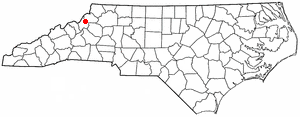
Watauga County is a county located in the U.S. state of North Carolina. As of the 2010 census, the population was 51,079. Its county seat and largest town is Boone. The county is in an exceptionally mountainous region. It is the home of Appalachian State University, which has approximately 15,000 students.
Banner Elk is a town in Avery County, North Carolina, United States. The population was 1,028 at the 2010 census. Banner Elk is home to Lees–McRae College.

Elizabethton is a city in, and the county seat of Carter County, Tennessee, United States. Elizabethton is the historical site of the first independent American government located west of both the Eastern Continental Divide and the original Thirteen Colonies.

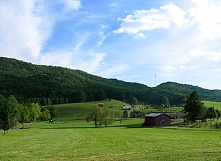
Roan Mountain is a census-designated place (CDP) in Carter County, Tennessee, United States. The population was 1,360 at the 2010 census. It is part of the Johnson City Metropolitan Statistical Area, which is a component of the Johnson City–Kingsport–Bristol, TN-VA Combined Statistical Area – commonly known as the "Tri-Cities" region.

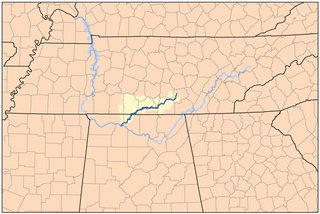
The Cumberland River is a major waterway of the Southern United States. The 688-mile-long (1,107 km) river drains almost 18,000 square miles (47,000 km2) of southern Kentucky and north-central Tennessee. The river flows generally west from a source in the Appalachian Mountains to its confluence with the Ohio River near Paducah, Kentucky, and the mouth of the Tennessee River. Major tributaries include the Obey, Caney Fork, Stones, and Red rivers.

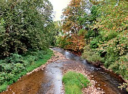
The Watauga River is a large stream of western North Carolina and East Tennessee. It is 78.5 miles (126.3 km) long with its headwaters on the slopes of Grandfather Mountain and Peak Mountain in Watauga County, North Carolina.

The Doe River is a tributary of the Watauga River in northeast Tennessee in the United States. The river forms in Carter County near the North Carolina line, just south of Roan Mountain State Park, and flows to Elizabethton.

The Nolichucky River is a 115-mile (185 km) river that flows through Western North Carolina and East Tennessee, in the southeastern United States. Traversing the Pisgah National Forest and the Cherokee National Forest in the Blue Ridge Mountains, the river's watershed is home to some of the highest mountains in the Appalachians, including Mount Mitchell, the highest point in the eastern United States. The river is a tributary of the French Broad River, and is impounded by Nolichucky Dam near Greeneville, Tennessee.
The Elk River is a tributary of the Tennessee River in the U.S. states of Tennessee and Alabama. The river is about 195 miles (314 km) long.
The Unaka Range is a mountain range on the border of Tennessee and North Carolina, in the southeastern United States. It is a subrange of the Appalachian Mountains and is part of the Blue Ridge Mountains physiographic province. The Unakas stretch approximately from the Nolichucky River to the south to the Watauga River to the north. The Unakas include the prominent Roan Highlands, where several summits rise above 6,000 feet. The Iron Mountains border the Unakas to the north, and the Bald Mountains border the Unakas opposite the Nolichucky to the south. The name unaka is rooted in the Cherokee term unega, meaning "white". Common Lore is that 1 in 4 trees in the Unaka Range were American Chestnut trees prior to the great Chestnut Blight. Chestnuts having long white blossoms, the Unaka Mountains turned white in color during the blossoming of the chestnut trees, and thus were called the White mountains by the local Cherokee.

The Overmountain Victory National Historic Trail (OVHT) is part of the U.S. National Trails System, and N.C. State Trail System. It recognizes the Revolutionary War Overmountain Men, Patriots from what is now East Tennessee who crossed the Unaka Mountains and then fought in the Battle of Kings Mountain in South Carolina.

The Sycamore Shoals of the Watauga River, usually shortened to Sycamore Shoals, is a rocky stretch of river rapids along the Watauga River in Elizabethton, Tennessee. Archeological excavations have found Native Americans lived near the shoals since prehistoric times, and Cherokees gathered there. As Europeans began settling the Trans-Appalachian frontier, the shoals proved strategic militarily, as well as shaped the economies of Tennessee and Kentucky. Today, the shoals are protected as a National Historic Landmark and are maintained as part of Sycamore Shoals State Historic Park.
Powell Mountain is a mountain ridge of the Ridge-and-valley Appalachians of the Appalachian Mountains. It is a long and narrow ridge, running northeast to southwest, from about Norton, Virginia to near Tazewell, Tennessee. It separates the Clinch River basin and the Powell River basin of Powell Valley. It was named for an 18th-century explorer.

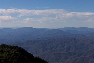
Roan Mountain is the highpoint of the Unaka Range of the Southern Appalachian Mountains, located in the Southeastern United States. The mountain is clad in a dense stand of Southern Appalachian spruce-fir forest, and includes the world's largest natural rhododendron garden, and the longest stretch of grassy bald in the Appalachian range. The Cherokee National Forest and Pisgah National Forest converge atop the mountain, with Roan Mountain State Park located near its northern base. The Appalachian Trail traverses most of the Roan's crest. The Roan High Knob Shelter is the highest back-country shelter on the entire 2,174-mile (3,499 km) trail.

Butler is an unincorporated community in Johnson County in the northeastern corner of the U.S. state of Tennessee. It is located along the northern shore of Watauga Lake. Butler is served by a post office, assigned ZIP Code 37640.
State Route 67 is a state-maintained highway in northeastern Tennessee, including a four-lane divided highway segments in both Washington County and Carter County, and part of a significant two-lane segment passing over the Butler Bridge some 80 feet (24 m) above the TVA Watauga Reservoir near Butler in Johnson County, Tennessee.
Doeville is an unincorporated community in Johnson County, Tennessee, United States. It is concentrated around the intersection of Tennessee State Route 67 and Tennessee State Route 167, west of Mountain City and east of Butler. The community of Pandora lies immediately to the northeast along S.R. 67.