
Carter County is a county located in the U.S. state of Tennessee. As of the 2020 census, the population was 56,356. Its county seat is Elizabethton. The county is named in honor of Landon Carter (1760-1800), an early settler active in the "Lost State of Franklin" 1784-1788 secession from the State of North Carolina. Carter County is part of the Johnson City, TN Metropolitan Statistical Area, which is a component of the Johnson City–Kingsport–Bristol, TN-VA Combined Statistical Area, located in northeastern Tennessee.

Elizabethton is a city in, and the county seat of Carter County, Tennessee, United States. Elizabethton is the historical site of the first independent American government located west of both the Eastern Continental Divide and the original Thirteen Colonies.
Hunter is a census-designated place (CDP) and unincorporated community located northeast of Elizabethton in Carter County, Tennessee, along Tennessee State Route 91 and the Watauga River. Its population was 1,854 as of the 2010 census. It is part of the Johnson City Metropolitan Statistical Area, which is a component of the Johnson City-Kingsport-Bristol, TN-VA Combined Statistical Area – commonly known as the "Tri-Cities" region. Hunter is a suburb of Elizabethton.

Roan Mountain is a census-designated place (CDP) in Carter County, Tennessee, United States. The population was 1,360 at the 2010 census. It is part of the Johnson City Metropolitan Statistical Area, which is a component of the Johnson City–Kingsport–Bristol, TN-VA Combined Statistical Area – commonly known as the Tri-Cities region.

Marenisco is an unincorporated community and census-designated place (CDP) in Marenisco Township, Gogebic County, Michigan, in the United States. As of the 2010 census, the CDP had a population of 254, out of a total population in the township of 1,727. The name of the community and the township was formed by combining the first three letters from Mary Enid Scott, the wife of E. H. Scott, a timber producer.
Summertown is an unincorporated community and census-designated place (CDP) in Lawrence County, Tennessee, United States. The population of Summertown was 866 at the 2010 census. The town has a ZIP Code of 38483. Some rural areas in neighboring Lewis and Maury counties also use a "Summertown" mailing address, but their population is not included in the Census figures.
Bliss is the largest hamlet and a census-designated place (CDP) in the town of Eagle, Wyoming County, New York, United States. As of the 2010 census, it had a population of 527.

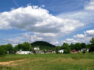
Hampton is an unincorporated community and Census-designated place in Carter County, Tennessee, United States. Located a few miles southeast of Elizabethton and northwest of Roan Mountain, Hampton is surrounded on all sides by the Unaka Mountains. It is part of the Johnson City Metropolitan Statistical Area, which is a component of the Johnson City–Kingsport–Bristol, TN-VA Combined Statistical Area – commonly known as the "Tri-Cities" region.
Waterbury Center is an unincorporated village and census-designated place (CDP) in the town of Waterbury, Washington County, Vermont, United States. As of the 2020 census, it had a population of 390.

Grimsley is an unincorporated community and census-designated place (CDP) in Fentress County, Tennessee, United States. Its population was 1,167 as of the 2010 census. Its ZIP code is 38565.
Swartzville is an unincorporated community and census-designated place (CDP) in East Cocalico Township, Lancaster County, Pennsylvania, United States. As of the 2010 census, the population was 2,283.
Wilmington is a hamlet and census-designated place (CDP) in the town of Wilmington in Essex County, New York, United States. The population of the CDP was 937 at the 2010 census, out of a total town population of 1,253.

Francestown is a census-designated place (CDP) and the main village in the town of Francestown, Hillsborough County, New Hampshire, United States. As of the 2020 census, the population of the CDP was 201, out of 1,610 in the entire town.
Clappertown is an unincorporated community and census-designated place (CDP) in Blair County, Pennsylvania, United States. It was first listed as a CDP prior to the 2020 census.
Cross Keys is an unincorporated community and census-designated place (CDP) in Blair County, Pennsylvania, United States. It was first listed as a CDP prior to the 2020 census.
Continental Courts is a mobile home park and census-designated place (CDP) in Centre County, Pennsylvania, United States. It was first listed as a CDP prior to the 2020 census.
Eagle Creek is a census-designated place (CDP) in Centre County, Pennsylvania, United States. It was first listed as a CDP prior to the 2020 census.
Horse Creek is an unincorporated community and census-designated place (CDP) in Mellette County, South Dakota, United States. It was first listed as a CDP prior to the 2020 census. The population of the CDP was 187 at the 2020 census.
Blanche is an unincorporated community and census-designated place (CDP) in Lincoln County, Tennessee, United States. It was first listed as a CDP prior to the 2020 census.
Rarity Bay is a golf course community and census-designated place (CDP) in Loudon and Monroe counties, Tennessee, United States. It was first listed as a CDP prior to the 2020 census. its population during the census was 885. It is in the southern part of Loudon County and the northern part of Monroe County, occupying a peninsula in Tellico Reservoir, with the Little Tennessee River to the southeast and the cove of Bat Creek to the northwest. Tennessee State Route 72 runs along the western edge of the CDP, leading south 2.5 miles (4.0 km) to U.S. Route 411 in Vonore and north 10 miles (16 km) to Loudon.


