Bitter End, Tennessee | |
|---|---|
 Bitter End, Tennessee  Bitter End, Tennessee | |
| Coordinates: 36°12′42″N82°02′24″W / 36.21167°N 82.04000°W | |
| Country | United States |
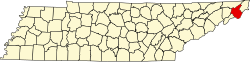
| State | Tennessee |
| County | Carter |
| Elevation | 3,455 ft (1,053 m) |
| Time zone | UTC-5 (Eastern (EST)) |
| • Summer (DST) | UTC-4 (EDT) |
| GNIS feature ID | 1314687 [1] |
Bitter End is an unincorporated community in Carter County, Tennessee, United States. [1]
It is located about 12 mi (19 km) southeast of Elizabethton.
The Markland Cemetery is located north of the settlement. [2] A historic school, the Bitter End School, was located to the south. [3]