
Lauderdale County is a county located in the northwestern corner of the U.S. state of Alabama. As of the 2010 census the population was 92,709. Its county seat is Florence. Its name is in honor of Colonel James Lauderdale, of Tennessee.

Van Buren County is a county located in the U.S. state of Tennessee. As of the 2010 census, the population was 5,548, making it the second-least populous county in Tennessee. Its county seat is Spencer.

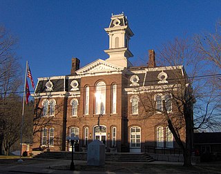
Marion County is a county located in the U.S. state of Tennessee. As of the 2010 census, the population was 28,237. Its county seat is Jasper.

Celina is a city in and the county seat of Clay County, Tennessee, United States. The population was 1,495 at the 2010 census.
Carthage is a town in and the county seat of Smith County, Tennessee, United States; it is part of the Nashville Metropolitan Statistical Area. The population was 2,306 at the 2010 census. It is located on the Cumberland River, which was important to its early development. It is likely best known as the hometown of former Vice President and Senator Al Gore of the Democratic Party and his father, Senator Albert Gore, Sr. The younger Gore announced his 1988 and 2000 presidential bids, as well as his 1992 vice-presidential bid, from the steps of the Smith County Courthouse.
The Little Doe River is a river located in Carter County, Tennessee. It forms from the confluence of Simerly Creek and Tiger Creek near the community of Tiger Valley, and runs in a northerly direction alongside U.S. Route 19E until its termination into Doe River just south of the town of Hampton, Tennessee.

Old Hickory Lake is a reservoir in north central Tennessee. It is formed by the Old Hickory Lock and Dam, located on the Cumberland River at mile 216.2 in Sumner and Davidson Counties, approximately 25 miles (40 km) upstream from Nashville. The city of Hendersonville is situated on the northern shoreline of the lake, and Old Hickory, a portion of Metropolitan Nashville-Davidson County, is located on the southern side of the lake, just upstream of the lock and dam. The lake extends 97.3 miles (156.6 km) upstream to Cordell Hull Lock and Dam, near Carthage, Tennessee. The dam and lake are named after President Andrew Jackson, who lived in the vicinity, at The Hermitage.

Pine River may refer to any of the following streams in the U.S. state of Michigan:
- Pine River. The main branch forms with the confluence of the East and West Branches of the Pine River at 44°29′38″N83°23′16″W in Alcona County. The South Branch joins approximately 1.5 miles (2.4 km) to the south and flows into Iosco County, where it empties into Van Etten Lake at 44°29′38″N83°23′16″W northwest of Oscoda.
- Pine River. The main branch is formed by the confluence of the North and Middle Branches northeast of Standish and flows into the Saginaw Bay of Lake Huron at 43°58′32″N83°51′16″W. The South Branch Pine River joins the main stream at 43°59′08″N83°53′17″W.
- Pine River is a short waterway, which along with Round Lake, connects Lake Charlevoix with Lake Michigan at Charlevoix.
- Pine River rises in Chippewa County and flows south through Mackinac County into the St. Martin Bay of Lake Huron at 46°03′09″N84°39′22″W The North Pine River, also known as the North Branch Pine River, joins at 46°12′20″N84°36′17″W. Another tributary, Hemlock Creek, is also known as Pine River.
- Pine River, also known as the South Branch Manistee River, rises in southeast Wexford County, flows southwest across northwest Osceola County, then west and north through the northeast corner of Lake County and back into southwest Wexford County, emptying into the Tippy Dam Pond on the Manistee River at 44°13′37″N85°54′27″W. The main stream is formed from the confluence of the East Branch Pine River with the North Branch Pine River at 44°06′02″N85°31′40″W. Another tributary, the Spaulding Creek, is also known as the Little Pine River
- Pine River, in Marquette County, is a very short stream draining Pine Lake into Lake Superior at 46°53′27″N87°52′13″W, north of the Huron Mountains.
- Pine River rises in from Pine Lake in eastern Mecosta County, flows mostly south and east through Isabella County, then south along eastern edge of Montcalm County, then east and north through Gratiot County and Midland County, emptying into the Chippewa River at 43°36′06″N84°17′33″W, just about two miles before it joins the Tittabawassee River near Midland. The South Branch Pine River joins the main stream at 43°30′37″N85°00′02″W Another tributary, Miller Creek, is also sometimes known as Pine River or the West Branch Pine River. The North Branch Pine River joins the main stream at 43°26′03″N84°50′18″W.
- Pine River empties into the St. Clair River at 42°49′13″N82°29′08″W on the south side of St. Clair. The South Branch Pine River joins the main stream at 42°58′11″N82°37′10″W. Another tributary, Quakenbush Drain, is also sometimes known as Pine River.
- Pine Creek empties into Lake Superior and is also known as the Pine River.

Dukedom is an unincorporated community in both Graves County, Kentucky and Weakley County, Tennessee, straddling the state line in the western part of both states. The location is 36°30′8″N88°42′54″W; The elevation is 487 feet above sea level.
Port Royal is an unincorporated community on the border of Montgomery and Robertson counties, Tennessee. It is home to Port Royal State Park and is located at the confluence of the Red River and Sulphur Fork Creek.
The Beaver River is the historic name for an intermittent river in Oklahoma that drains most of the Oklahoma Panhandle. It is also known as the North Canadian River; both names are in common use. The Beaver River flows from Union County, New Mexico, entering the Oklahoma Panhandle in Cimarron County, then flowing out of state through Sherman County in the Texas Panhandle for about 15 miles (24 km), then back to the Oklahoma panhandle in Texas County, where it is impounded in Optima Lake near Guymon. Downstream of the dam, it continues through the Oklahoma counties of Beaver and Harper before ending in Woodward County.

Butler is an unincorporated community in Johnson County in the northeastern corner of the U.S. state of Tennessee. It is located along the northern shore of Watauga Lake. Butler is served by a post office, assigned ZIP Code 37640.
Cedar Creek may refer to several small streams in the U.S. state of Michigan:

The Betsie River is a 54.0-mile-long (86.9 km) stream in the northwest part of the U.S. state of Michigan. The name is derived from the French la rivière aux Bec-scies, meaning river of sawbill ducks (bec-scie). Other alternate names include Aug-sig-o-sebe, Aux Buscies, Betsey's River, Black Robe, Gay-she-say-ing, Riviere du Pere Marquette, Sawbill Ducks, and Shelldrake Ducks. The river is mostly within Benzie County, although the river rises in southwest Grand Traverse County and flows briefly through northern Manistee County, Michigan.

Defeated is an unincorporated community in Smith County, Tennessee, United States. It is located northeast of Carthage along Defeated Creek, a tributary of the Cumberland River. State Route 85 passes through the community.
Suck Creek is an unincorporated community in Hamilton and Marion Counties, in the U.S. state of Tennessee.
State Route 85 is an east-west state highway in Middle Tennessee. The 85.24 miles (137.18 km)-long road traverses portions of Smith, Jackson, Overton, and Fentress Counties.
State Route 262 (SR 262) is an east–west state highway in Middle Tennessee. it traverses Macon and Jackson counties.
State Route 135 is a north–south secondary state highway located in eastern Middle Tennessee. it originates in White County along SR 289 on the north side of Sparta, and its northern end is in Clay County along SR 52. The total length is 62.87 miles (101.18 km) long, and is entirely a secondary state highway.

