Carthage, Tennessee

Last updated

Carthage, Tennessee
Smith-county-courthouse-tn1.JPG
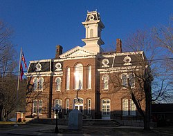
Smith County Courthouse in Carthage
Smith County Tennessee Incorporated and Unincorporated areas Carthage Highlighted 4711280.svg
Location of Carthage in Smith County, Tennessee.
USA Tennessee relief location map.svg
Red pog.svg
Carthage
Location within Tennessee
Usa edcp relief location map.png
Red pog.svg
Carthage
Location within the United States
Coordinates: 36°15′18″N85°56′57″W / 36.25500°N 85.94917°W / 36.25500; -85.94917
Country United States
State Tennessee
County Smith
Settled1789
Incorporated1804 [1]
Named for Ancient Carthage [2]
Area
[3]
  Total2.90 sq mi (7.52 km2)
  Land2.90 sq mi (7.52 km2)
  Water0.00 sq mi (0.00 km2)
Elevation
515 ft (157 m)
Population
 (2020) [4]
  Total2,291
  Density789.46/sq mi (304.78/km2)
Time zone UTC-6 (Central (CST))
  Summer (DST) UTC-5 (CDT)
ZIP code
37030
Area code 615
FIPS code 47-11280 [5]
GNIS feature ID1279827 [6]
Website townofcarthagetn.com

Carthage is a town in and the county seat of Smith County, Tennessee, United States; it is part of the Nashville Metropolitan Statistical Area. [7] The population was 2,306 at the 2010 census. [8] It is located on the Cumberland River, which was important to its early development. It is likely best known as the hometown of former Vice President and Senator Al Gore of the Democratic Party and his father, Senator Albert Gore, Sr. The younger Gore announced his 1988 and 2000 presidential bids, as well as his 1992 vice-presidential bid, from the steps of the Smith County Courthouse.

Contents

History

The earliest known European-American settler in what is now Carthage was William Walton (1760–1816), who arrived in the late 1780s after the United States achieved independence in the American Revolutionary War. [9] Circa 1800, Walton directed the construction of the Walton Road (Cumberland Turnpike), an early stagecoach route connecting the Knoxville area in the east with Middle Tennessee. The road, which was roughly paralleled later by the construction of what is now U.S. 70, was influential to the development and early settlement of the Cumberland region. [10] Walton operated a ferry across the Cumberland River and a tavern nearby along the road, around which a small community developed. In 1804, Walton's community was chosen as the county seat of the newly formed Smith County after a heated election, and the town of Carthage was laid out shortly thereafter. [11]

Carthage's location at the confluence of the Caney Fork and Cumberland rivers made it an important shipping and steamboat port throughout the first half of the 19th century. The area was developed for tobacco and hemp crops, as well as blooded livestock. Goods were shipped downstream to Nashville. During the Civil War, Carthage became an important post in the Eastern Highland Rim area of Tennessee. Carthage was selected as part of the route Confederate General Braxton Bragg marched the Army of Mississippi through on his Confederate Heartland Offensive into Kentucky. Later on March 6, 1863, [12] Union Brigadier General George Crook established a Union outpost in Carthage to serve as a base for his effort to clear out the considerable Confederate guerrilla insurgency from East Tennessee through Middle Tennessee.

Carthage's prominence as a river port on the Cumberland River was superseded after the railroads replaced river traffic in the later 19th century. The area's industrial focus shifted to South Carthage and Gordonsville. [11]

Geography

Carthage is located at 36°15′18″N85°56′57″W / 36.25500°N 85.94917°W / 36.25500; -85.94917 (36.254960, -85.949211). [13] The town is situated amid a series of low hills at the confluence of the Caney Fork with the Cumberland River, and just southwest of the latter's Cordell Hull Lake impoundment. South Carthage is located along the opposite bank of the Cumberland to the south.

U.S. Route 70 passes east-to-west through South Carthage, connecting the area with Nashville to the west and Cookeville to the east. State Route 53 connects U.S. 70 with Gordonsville and Interstate 40 to the south. State Route 25 connects Carthage with Trousdale County and north-central Tennessee to the northwest, and State Route 80 connects the town with Macon County to the north.

According to the United States Census Bureau, the town has a total area of 2.9 square miles (7.5 km2), all land.

Demographics

Historical population
CensusPop.Note
1870 477
1880 327−31.4%
1890 47846.2%
1910 904
1920 9201.8%
1930 1,06816.1%
1940 1,51241.6%
1950 1,6046.1%
1960 2,02126.0%
1970 2,49123.3%
1980 2,6727.3%
1990 2,386−10.7%
2000 2,251−5.7%
2010 2,3062.4%
2020 2,291−0.7%
Sources: [14] [15] [4]

2020 census

Carthage racial composition [16]
RaceNumberPercentage
White (non-Hispanic)1,98486.6%
Black or African American (non-Hispanic)1054.58%
Native American 50.22%
Asian 261.13%
Other/Mixed 833.62%
Hispanic or Latino 883.84%

As of the 2020 United States census, there were 2,291 people, 947 households, and 528 families residing in the town.

2000 census

As of the census [5] of 2000, there were 2,251 people, 952 households, and 560 families residing in the town. The population density was 784.5 inhabitants per square mile (302.9/km2). There were 1,050 housing units at an average density of 365.9 per square mile (141.3/km2). The racial makeup of the town was 90.67% White, 6.53% African American, 0.27% Native American, 0.53% Asian, 0.76% from other races, and 1.24% from two or more races. Hispanic or Latino of any race were 1.16% of the population.

The Carthage business district Carthage-tennessee-old-town1.jpg
The Carthage business district

There were 952 households, out of which 25.9% had children under the age of 18 living with them, 38.2% were married couples living together, 16.5% had a female householder with no husband present, and 41.1% were non-families. 38.2% of all households were made up of individuals, and 21.6% had someone living alone who was 65 years of age or older. The average household size was 2.22 and the average family size was 2.93.

In the town, the population was spread out, with 21.9% under the age of 18, 8.6% from 18 to 24, 23.9% from 25 to 44, 22.7% from 45 to 64, and 22.7% who were 65 years of age or older. The median age was 42 years. For every 100 females, there were 80.1 males. For every 100 females age 18 and over, there were 72.6 males.

The median income for a household in the town was $24,375, and the median income for a family was $32,159. Males had a median income of $30,531 versus $20,417 for females. The per capita income for the town was $18,709. About 18.6% of families and 20.6% of the population were below the poverty line, including 23.0% of those under age 18 and 19.2% of those age 65 or over.

Education

Carthage and other surrounding areas in Smith County are served by Smith County Schools and the Smith County Board of Education. They include:

Climate

The climate in this area is characterized by hot, humid summers and generally mild to cool winters. According to the Köppen Climate Classification system, Carthage has a humid subtropical climate, abbreviated "Cfa" on climate maps. [17]

Climate data for carthage, Tennessee (1991–2020 normals, extremes 1890–present)
MonthJanFebMarAprMayJunJulAugSepOctNovDecYear
Record high °F (°C)88
(31)
83
(28)
92
(33)
95
(35)
98
(37)
105
(41)
110
(43)
111
(44)
108
(42)
97
(36)
87
(31)
77
(25)
111
(44)
Mean daily maximum °F (°C)48.1
(8.9)
52.5
(11.4)
61.4
(16.3)
71.3
(21.8)
78.7
(25.9)
85.7
(29.8)
89.0
(31.7)
88.4
(31.3)
83.7
(28.7)
73.1
(22.8)
61.5
(16.4)
51.7
(10.9)
70.4
(21.3)
Daily mean °F (°C)37.6
(3.1)
41.1
(5.1)
48.8
(9.3)
57.9
(14.4)
66.4
(19.1)
74.2
(23.4)
78.1
(25.6)
76.8
(24.9)
71.3
(21.8)
59.8
(15.4)
48.8
(9.3)
41.1
(5.1)
58.5
(14.7)
Mean daily minimum °F (°C)27.0
(−2.8)
29.6
(−1.3)
36.1
(2.3)
44.5
(6.9)
54.1
(12.3)
62.8
(17.1)
67.1
(19.5)
65.2
(18.4)
58.8
(14.9)
46.5
(8.1)
36.0
(2.2)
30.4
(−0.9)
46.5
(8.1)
Record low °F (°C)−17
(−27)
−15
(−26)
3
(−16)
21
(−6)
30
(−1)
40
(4)
49
(9)
46
(8)
32
(0)
23
(−5)
0
(−18)
−9
(−23)
−17
(−27)
Average precipitation inches (mm)4.49
(114)
4.86
(123)
5.01
(127)
4.41
(112)
4.73
(120)
5.03
(128)
4.97
(126)
3.71
(94)
3.40
(86)
3.43
(87)
3.55
(90)
4.92
(125)
52.51
(1,334)
Average snowfall inches (cm)0.5
(1.3)
0.7
(1.8)
0.2
(0.51)
0.0
(0.0)
0.0
(0.0)
0.0
(0.0)
0.0
(0.0)
0.0
(0.0)
0.0
(0.0)
0.0
(0.0)
0.0
(0.0)
0.1
(0.25)
1.5
(3.8)
Average precipitation days (≥ 0.01 in)10.210.210.810.210.39.810.18.07.47.48.310.3113.0
Average snowy days (≥ 0.1 in)0.70.60.20.00.00.00.00.00.00.00.10.21.8
Source: NOAA [18] [19]

Notable residents

Related Research Articles

<span class="mw-page-title-main">Putnam County, Tennessee</span> County in Tennessee, United States

Putnam County is a county located in the U.S. state of Tennessee. As of the 2020 census, the population was 79,854. Its county seat is Cookeville. Putnam County is part of the Cookeville, TN Micropolitan Statistical Area.

<span class="mw-page-title-main">Smith County, Tennessee</span> County in Tennessee, United States

Smith County is a county in the U.S. state of Tennessee. As of the 2020 census, the population was 19,904. Smith County is located in the region of the state known as Middle Tennessee. Its county seat is Carthage. The county was organized in 1799 and is named for Daniel Smith, a Revolutionary War veteran who made the first map of Tennessee and served as a United States senator.

<span class="mw-page-title-main">Scott County, Tennessee</span> County in Tennessee, United States

Scott County is a county located in the U.S. state of Tennessee. As of the 2020 census, its population was 22,039, down from 22,228 at the 2010 census. Its county seat is Huntsville and the largest town is Oneida. Scott County is known for having seceded from Tennessee in protest of the state's decision to join the Confederacy during the Civil War, and subsequently forming The Free and Independent State of Scott.

<span class="mw-page-title-main">Pickett County, Tennessee</span> County in Tennessee, United States

Pickett County is a county located in the U.S. state of Tennessee. As of the 2020 census, the population was 5,001, making it the least populous county in Tennessee. Its county seat is Byrdstown. The city of Byrdstown and the Kentucky town of Albany, 11 miles (18 km) to the northeast, are positioned between two Army Corps of Engineers lakes: Dale Hollow Lake, mainly in Tennessee, and Lake Cumberland, in Kentucky. The area is known as "Twin Lakes" and Byrdstown is noted as "The Gateway To Dale Hollow Lake". Every year thousands of people vacation at the many resorts situated along the lakes.

<span class="mw-page-title-main">Jackson County, Tennessee</span> County in Tennessee, United States

Jackson County is a county located in the U.S. state of Tennessee. The population was 11,617 at the 2020 census. Its county seat is Gainesboro. Jackson is part of the Cookeville Micropolitan Statistical Area.

<span class="mw-page-title-main">Burkesville, Kentucky</span> City in Kentucky, United States

Burkesville is a home rule-class city in Cumberland County, Kentucky, in the United States. Nestled among the rolling foothills of Appalachia and bordered by the Cumberland River to the south and east, it is the seat of its county. The population was 1,521 at the 2010 census.

<span class="mw-page-title-main">Woodbury, Tennessee</span> Town in Tennessee, United States

Woodbury is a town in Cannon County, Tennessee, United States. Woodbury is part of the Nashville Metropolitan Statistical Area and is located 55 miles (89 km) southeast of downtown Nashville. The population of Woodbury was 2,680 at the 2010 census. It is the county seat of Cannon County.

<span class="mw-page-title-main">Celina, Tennessee</span> City in Tennessee, United States

Celina is a city in and the county seat of Clay County, Tennessee, United States. The population was 1,495 at the 2010 census.

<span class="mw-page-title-main">Crab Orchard, Tennessee</span> City in Tennessee, United States

Crab Orchard is a city in Cumberland County, Tennessee, United States. The population was 719 at the 2020 census.

<span class="mw-page-title-main">Crossville, Tennessee</span> City in Tennessee, United States

Crossville is a city in and the county seat of Cumberland County, Tennessee, United States. It is part of the Crossville Micropolitan Statistical Area. The population was 12,071 at the 2020 census.

<span class="mw-page-title-main">Charlotte, Tennessee</span> Town in Tennessee, United States

Charlotte is a town in Dickson County, Tennessee, United States. The population was 1,656 at the 2020 census. It is the county seat of Dickson County. This town is part of the Nashville metropolitan area.

<span class="mw-page-title-main">Lafayette, Tennessee</span> City in Tennessee, United States

Lafayette is a city in Macon County, Tennessee, United States. The population was 4,474 at the 2010 census, and had 5,584 in 2020. It is the county seat of Macon County.

<span class="mw-page-title-main">Livingston, Tennessee</span> Town in Tennessee, United States

Livingston is a town in Overton County, Tennessee, United States, and serves as the county seat. The population was 3,905 at the 2020 census and 4,058 at the 2010 census. The current mayor, Curtis Hayes, began serving his mayoral position in September 2006.

<span class="mw-page-title-main">Monterey, Tennessee</span> Town in Tennessee, United States

Monterey is a town in Putnam County, Tennessee, United States. The population was 2,850 at the 2010 census. It is part of the Cookeville, Tennessee Micropolitan Statistical Area.

<span class="mw-page-title-main">Gordonsville, Tennessee</span> Town in Tennessee, United States

Gordonsville is a town in Smith County, Tennessee, United States. The population was 1,213 at the 2010 census.

<span class="mw-page-title-main">South Carthage, Tennessee</span> Town in Tennessee, United States

South Carthage is a town in Smith County, Tennessee, United States. The population was 1,322 at the 2010 census. The town is located along the Cumberland River opposite Carthage.

<span class="mw-page-title-main">Hartsville, Tennessee</span> Consolidated city-county in Tennessee, United States

Hartsville is a town in Trousdale County, Tennessee, United States. It is the county seat of Trousdale County, with which it shares a consolidated city-county government. The population of Hartsville was 11,615 as of 2020.

<span class="mw-page-title-main">Lebanon, Tennessee</span> City in Tennessee, United States

Lebanon is the county seat of Wilson County, Tennessee, United States. The population was 38,431 at the 2020 census. Lebanon is located in Middle Tennessee, approximately 25 miles (40 km) east of downtown Nashville. Lebanon is part of the Nashville Metropolitan Statistical Area.

<span class="mw-page-title-main">Nashville metropolitan area</span> Metropolitan area in Tennessee, United States

The Nashville metropolitan area is a metropolitan statistical area in north-central Tennessee. Its principal city is Nashville, the capital of and largest city in Tennessee. With a population of over 2 million, it is the most populous metropolitan area in Tennessee. It is also the largest metropolitan area in Tennessee in terms of land area.

<span class="mw-page-title-main">Tennessee State Route 53</span> Highway in Tennessee

State Route 53 (SR 53) is a north–south state highway that traverses six counties in Middle Tennessee. It is 113.5 miles (182.7 km) long.

References

  1. Tennessee Blue Book , 2005-2006, pp. 618-625.
  2. Larry Miller, Tennessee Place Names (Indiana University Press, 2001), p. 39.
  3. "ArcGIS REST Services Directory". United States Census Bureau. Retrieved October 15, 2022.
  4. 1 2 "Census Population API". United States Census Bureau. Retrieved October 15, 2022.
  5. 1 2 "U.S. Census website". United States Census Bureau . Retrieved January 31, 2008.
  6. "US Board on Geographic Names". United States Geological Survey. October 25, 2007. Retrieved January 31, 2008.
  7. "Find a County". National Association of Counties. Archived from the original on May 31, 2011. Retrieved June 7, 2011.
  8. "Geographic Identifiers: 2010 Demographic Profile Data (DP-1): Carthage town, Tennessee". U.S. Census Bureau, American Factfinder. Archived from the original on February 10, 2020. Retrieved March 25, 2013.
  9. "The History of Smith County", Smith County Chamber of Commerce, Retrieved: 17 January 2013.
  10. W. Calvin Dickenson, "Walton Road", The Tennessee Encyclopedia of History and Culture, 2009. Retrieved: January 17, 2013.
  11. 1 2 Sue Maggart, "Smith County", The Tennessee Encyclopedia of History and Culture, 2009. Retrieved: January 17, 2013.
  12. Official Record of the War of the Rebellion, Series I, Volume XXIII, Part II, No. 110
  13. "US Gazetteer files: 2010, 2000, and 1990". United States Census Bureau. February 12, 2011. Retrieved April 23, 2011.
  14. "Census of Population and Housing: Decennial Censuses". United States Census Bureau . Retrieved March 4, 2012.
  15. "Incorporated Places and Minor Civil Divisions Datasets: Subcounty Resident Population Estimates: April 1, 2010 to July 1, 2012". Population Estimates. U.S. Census Bureau. Archived from the original on June 11, 2013. Retrieved December 11, 2013.
  16. "Explore Census Data". data.census.gov. Retrieved December 27, 2021.
  17. "Carthage, Tennessee Köppen Climate Classification (Weatherbase)". Weatherbase.
  18. "NowData - NOAA Online Weather Data". National Oceanic and Atmospheric Administration. Retrieved September 25, 2021.
  19. "Station: Carthage, TN". U.S. Climate Normals 2020: U.S. Monthly Climate Normals (1991-2020). National Oceanic and Atmospheric Administration. Retrieved September 25, 2021.

36°15′18″N85°56′57″W / 36.25496°N 85.949211°W / 36.25496; -85.949211