Henderson, Tennessee

Last updated

Henderson, Tennessee
Downtown henderson tennessee.jpg
Shops in Henderson
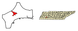
Chester County Tennessee Incorporated and Unincorporated areas Henderson Highlighted 4733260.svg
Location of Henderson in Chester County, Tennessee.
Coordinates: 35°26′35″N88°38′40″W / 35.44306°N 88.64444°W / 35.44306; -88.64444
Country United States
State Tennessee
County Chester
Government
  MayorBobby King
Area
[1]
  Total7.83 sq mi (20.29 km2)
  Land7.80 sq mi (20.22 km2)
  Water0.03 sq mi (0.07 km2)
Elevation
446 ft (136 m)
Population
 (2020) [2]
  Total6,308
  Density808.20/sq mi (312.04/km2)
Time zone UTC-6 (Central (CST))
  Summer (DST) UTC-5 (CDT)
ZIP code
38340
Area code 731
FIPS code 47-33260 [3]
GNIS feature ID1287374 [4]
Website hendersontn.org

Henderson is a city in and the county seat of Chester County, Tennessee, United States. [5] The population was 6,309 at the 2010 census, [6] up from 5,670 at the 2000 census.

Contents

History

Henderson was platted in 1857, when the railroad was extended to that point. [7] The city takes its name from Henderson County, Tennessee. [7] Henderson was called Dayton during the Civil War, then was known as Henderson Station and, finally, Henderson. [8]

Geography

Henderson is located near the center of Chester County at 35°26′35″N88°38′40″W / 35.44306°N 88.64444°W / 35.44306; -88.64444 (35.443025, -88.644345), [9] to the west of the South Fork Forked Deer River. U.S. Route 45 passes through the city, leading northwest 17 miles (27 km) to Jackson and south 20 miles (32 km) to Selmer. Tennessee State Route 100 passes south of the city center, leading east 32 miles (51 km) to Decaturville and west 30 miles (48 km) to Whiteville.

According to the United States Census Bureau, the city has a total area of 7.9 square miles (20.4 km2), of which 0.03 square miles (0.07 km2), or 0.35%, is water. [6]

Arts, culture and outdoors

For several years, the Henderson Arts Commission has sponsored many arts-related events and programs, like the Summer Camp Theatre Experience. [10]

The city park is called Gene Record Park. It features playground equipment, a walking trail, soccer fields, a permanent space for the local Farmer's Market, picnic tables, a dog park, and a 9-hole disc golf course. [11] In January 2020, the city paper (Chester County Independent) reported that a Splash Pad would soon be installed at the park. [12]

Since 1978, Henderson has also been the site of the Chester County Barbecue Festival, a regional event that celebrates the barbecue tradition of the area. [13] The first pitmaster for the Chester County Barbecue Festival was Bill Howard, a pitmaster from Jacks Creek, Tennessee who was known throughout Chester County as "The Barbecue King". [14] Howard was chosen by the Smithsonian Folklife Festival to represent Afro-American barbecue and was invited to serve barbecue in Washington, DC in 1986. [14] [15]

Newspaper

The local paper, the Chester County Independent, is based in Henderson.

Demographics

Historical population
CensusPop.Note
1880 493
1890 1,069116.8%
1910 1,087
1920 1,1818.6%
1930 1,50327.3%
1940 1,77117.8%
1950 2,53243.0%
1960 2,6916.3%
1970 3,58133.1%
1980 4,44924.2%
1990 4,7607.0%
2000 5,67019.1%
2010 6,30911.3%
2020 6,3080.0%
Sources: [16] [17] [2]

2020 census

Henderson racial composition [18]
RacePerc.
White (non-Hispanic)68.6%
Black or African American (non-Hispanic)22.2%
Native American 0%
Asian 1.2%
Other/Mixed 3.9%
Hispanic or Latino 6%

As of the 2020 United States census, there were 6,308 people, 1,992 households, and 1,261 families residing in the city.

2000 census

As of the census [3] of 2000, there were 5,670 people, 1,896 households, and 1,270 families residing in the city. The population density was 991.6 inhabitants per square mile (382.9/km2). There were 2,072 housing units at an average density of 362.4 per square mile (139.9/km2). The racial makeup of the city was 80.09% White, 17.87% African American, 0.09% Native American, 0.41% Asian, 0.37% from other races, and 1.18% from two or more races. Hispanic or Latino of any race were 1.52% of the population.

There were 1,896 households, out of which 31.8% had children under the age of 18 living with them, 47.0% were married couples living together, 16.6% had a female householder with no husband present, and 33.0% were non-families. 28.7% of all households were made up of individuals, and 14.3% had someone living alone who was 65 years of age or older. The average household size was 2.41 and the average family size was 2.96.

In the city, the population was spread out, with 21.5% under the age of 18, 25.2% from 18 to 24, 22.5% from 25 to 44, 16.0% from 45 to 64, and 14.8% who were 65 years of age or older. The median age was 27 years. For every 100 females, there were 85.4 males. For every 100 females age 18 and over, there were 80.0 males.

The median income for a household in the city was $32,648, and the median income for a family was $40,907. Males had a median income of $32,215 versus $22,258 for females. The per capita income for the city was $16,735. About 15.4% of families and 19.0% of the population were below the poverty line, including 27.6% of those under age 18 and 20.1% of those age 65 or over.

Education

Chester County Courthouse, 2003 Chester county tennessee courthouse.jpg
Chester County Courthouse, 2003

Henderson is part of the Chester County School District and home to Chester County High School. It is also the home of Freed-Hardeman University.

Notable people

Related Research Articles

<span class="mw-page-title-main">Hardeman County, Texas</span> County in Texas, United States

Hardeman County is a county located in the U.S. state of Texas. As of the 2020 census, its population was 3,549. The county seat and largest city is Quanah. The county was created in 1858 and later organized in 1884. It is named for two brothers, Bailey Hardeman and Thomas Jones Hardeman, early Texas politicians and legislators. Hardeman County was one of 46 prohibition or entirely dry counties in the state of Texas until November 2006, when voters approved referendums to permit the legal sale of alcoholic beverages for on- and off-premises consumption.

<span class="mw-page-title-main">McNairy County, Tennessee</span> County in Tennessee, United States

McNairy County is a county located in the U.S. state of Tennessee. As of the 2020 census, the population was 25,866. Its county seat and largest city is Selmer. McNairy County is located along Tennessee's border with the state of Mississippi.

<span class="mw-page-title-main">Madison County, Tennessee</span> County in Tennessee, United States

Madison County is a county located in the western part of the U.S. state of Tennessee. As of the 2020 census, the population was 98,823. Its county seat is Jackson. Madison County is included in the Jackson, TN Metropolitan Statistical Area.

<span class="mw-page-title-main">Henderson County, Tennessee</span> County in Tennessee, United States

Henderson County is a county located in the U.S. state of Tennessee. As of the 2020 census, the population was 27,842. Its county seat is Lexington. The county was founded in 1821 and named for James Henderson, a soldier in the War of 1812.

<span class="mw-page-title-main">Hardeman County, Tennessee</span> County in Tennessee, United States

Hardeman County is a county located in the U.S. state of Tennessee. As of the 2020 census, the population was 25,462. Its county seat is Bolivar.

<span class="mw-page-title-main">Chester County, Tennessee</span> County in Tennessee, United States

Chester County is a county located in the U.S. state of Tennessee. As of the 2020 census, the population was 17,341. Its county seat is Henderson. The county was created in 1879 and organized in 1882. Chester County is included in the Jackson, TN Metropolitan Statistical Area.

<span class="mw-page-title-main">Henderson, Kentucky</span> City in Kentucky, United States

Henderson is a home rule-class city along the Ohio River and the county seat of Henderson County, Kentucky, United States. The population was 29,781 at the 2020 U.S. census. It is part of the Evansville Metropolitan Area, locally known as the "Tri-State Area," and is considered the southernmost suburb of Evansville, Indiana.

<span class="mw-page-title-main">Henderson, North Carolina</span> City in North Carolina, United States

Henderson is a city and the county seat of Vance County, North Carolina, United States. The population was 15,060 at the 2020 census.

<span class="mw-page-title-main">Kittanning Township, Armstrong County, Pennsylvania</span> Township in Pennsylvania, United States

Kittanning Township is a township in Armstrong County, Pennsylvania, United States. The population was 2,019 at the 2020 census, a decrease from the figure of 2,265 tabulated in 2010.

<span class="mw-page-title-main">Bolivar, Tennessee</span> City in Tennessee, United States

Bolivar is a city in and the county seat of Hardeman County, Tennessee, United States. The town was named for South American revolutionary leader Simón Bolívar. As of the 2010 census, the city population was 5,417.

<span class="mw-page-title-main">Middleton, Tennessee</span> City in Tennessee, United States

Middleton is a city in Hardeman County, Tennessee, United States. The population was 706 at the 2010 census, up from 602 at the 2000 census. It is located at the intersection of Tennessee State Route 125 and Tennessee State Route 57. Its slogan is the "Crossroads of the South".

<span class="mw-page-title-main">Lexington, Tennessee</span> City in Tennessee, United States

Lexington is a city in Henderson County, Tennessee, United States. Lexington is midway between Memphis and Nashville, lying 10 miles (16 km) south of Interstate 40, which connects the two cities. The population was 7,956 at the 2020 census. It is the county seat of Henderson County.

<span class="mw-page-title-main">McEwen, Tennessee</span> City in Tennessee, United States

McEwen is a city in Humphreys County, Tennessee, United States. The population was 1,750 at the 2010 census.

<span class="mw-page-title-main">Greenbrier, Tennessee</span> City in Tennessee, United States

Greenbrier is a city in Robertson County, Tennessee, United States. The population was 6,433 at the 2010 census, and at the 2020 census the population was 6,898.

<span class="mw-page-title-main">New Market, Virginia</span> Town in Virginia, United States

New Market is a town in Shenandoah County, Virginia, United States. Founded as a small crossroads trading town in the Shenandoah Valley, it has a population of 2,146 as of the most recent 2010 U.S. census. The north–south U.S. 11 and the east–west U.S. 211 pass near it and cross Massanutten Mountain at the town's titular gap.

<span class="mw-page-title-main">Mulvane, Kansas</span> City in Sedgwick and Sumner County, Kansas

Mulvane is a city in Sedgwick and Sumner counties in the U.S. state of Kansas. As of the 2020 census, the population of the city was 6,286.

<span class="mw-page-title-main">Milledgeville, Tennessee</span> Town in Tennessee, United States

Milledgeville is a town in Chester, Hardin, and McNairy counties, Tennessee, United States. The population was 265 at the 2010 census.

<span class="mw-page-title-main">Silerton, Tennessee</span> Town in Tennessee, United States

Silerton is a town in Hardeman and Chester counties in the western part of Tennessee. The population was 111 at the 2010 census.

<span class="mw-page-title-main">Elbridge (village), New York</span> Village in New York, United States

Elbridge is a village. Located in the western part of the town of Elbridge in western Onondaga County, New York, United States, about 15 miles (24 km) west of Syracuse. It is part of the Syracuse Metropolitan Statistical Area. As of the 2020 census, the population was 921.

<span class="mw-page-title-main">Cross Plains, Wisconsin</span> Village in Wisconsin, United States

Cross Plains is a village in Dane County, Wisconsin, United States. The population was 4,104 at the 2020 census. The village is located partially within the Town of Cross Plains. It is part of the Madison Metropolitan Statistical Area.

References

  1. "ArcGIS REST Services Directory". United States Census Bureau. Retrieved October 15, 2022.
  2. 1 2 "Census Population API". United States Census Bureau. Retrieved October 15, 2022.
  3. 1 2 "U.S. Census website". United States Census Bureau . Retrieved January 31, 2008.
  4. "US Board on Geographic Names". United States Geological Survey . October 25, 2007. Retrieved January 31, 2008.
  5. "Find a County". National Association of Counties. Archived from the original on May 31, 2011. Retrieved June 7, 2011.
  6. 1 2 "Geographic Identifiers: 2010 Census Summary File 1 (G001): Henderson city, Tennessee". U.S. Census Bureau, American Factfinder. Archived from the original on February 13, 2020. Retrieved July 6, 2015.
  7. 1 2 History of Tennessee from the Earliest Time to the Present. Southern Historical Press. 1886. p. 809. ISBN   978-0-893080976.
  8. Chester County Tennessee. Turner Publishing Company. 1995. p. 12. ISBN   1-56311-195-0.
  9. "US Gazetteer files: 2010, 2000, and 1990". United States Census Bureau . February 12, 2011. Retrieved April 23, 2011.
  10. "Home". Henderson Arts Commission. Retrieved May 20, 2020.
  11. "Friends of Gene Record Park". FaceBook. Retrieved May 20, 2020.
  12. Morris, Kevin (January 22, 2020). "Coming Soon: Splash Pad is Coming to Gene Record Memorial Park". Chester County Independent.
  13. "Events". Chester County Chamber of Commerce.
  14. 1 2 "History". Chester County Chamber of Commerce.
  15. "1986 Festival of American Folklife" (PDF). Smithsonian Center for Folklife and Cultural Heritage. 2017.
  16. "Census of Population and Housing: Decennial Censuses". United States Census Bureau . Retrieved March 4, 2012.
  17. "Annual Estimates of the Resident Population: April 1, 2010 to July 1, 2014 (PEPANNRES): Incorporated Places in Tennessee". U.S. Census Bureau. Archived from the original on February 13, 2020. Retrieved December 11, 2013.
  18. "Explore Census Data". United States Census Bureau. Retrieved December 8, 2021.