Milledgeville, Tennessee

Last updated

Milledgeville, Tennessee
Milledgeville-Main-St-tn.jpg
Main Street
McNairy County Tennessee Incorporated and Unincorporated areas Milledgeville Highlighted 4748920.svg
Location of Milledgeville in McNairy County, Tennessee.
Coordinates: 35°22′38″N88°21′52″W / 35.37722°N 88.36444°W / 35.37722; -88.36444
Country United States
State Tennessee
Counties McNairy, Chester, Hardin
Incorporated1983
Area
[1]
  Total1.61 sq mi (4.16 km2)
  Land1.61 sq mi (4.16 km2)
  Water0.00 sq mi (0.00 km2)
Elevation
420 ft (128 m)
Population
 (2020) [2]
  Total271
  Density168.64/sq mi (65.10/km2)
Time zone UTC-6 (Central (CST))
  Summer (DST) UTC-5 (CDT)
ZIP code
38359
Area code 731
FIPS code 47-48920 [3]
GNIS feature ID1647832 [4]

Milledgeville is a town in Chester, Hardin, and McNairy counties, Tennessee, United States. The population was 265 at the 2010 census.

Contents

Geography

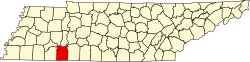
Milledgeville is located at 35°22′38″N88°21′52″W / 35.37722°N 88.36444°W / 35.37722; -88.36444 (35.377337, -88.364339). [5] The largest portion of the town lies in McNairy County, with portions extending into Chester and Hardin Counties. In the 2000 census, 130 of the town's 287 residents (45.3%) lived in McNairy County, 83 (28.9%) in Chester County, and 74 (25.8%) in Hardin County. [6]

According to the United States Census Bureau, the town has a total area of 1.6 square miles (4.2 km2), all land.

Demographics

Historical population
CensusPop.Note
1970 349
1980 39212.3%
1990 279−28.8%
2000 2872.9%
2010 265−7.7%
2020 2712.3%
Sources: [7] [8] [2]

As of the census [3] of 2000, there were 287 people, 135 households, and 95 families residing in the town. The population density was 178.1 inhabitants per square mile (68.8/km2). There were 154 housing units at an average density of 95.5 per square mile (36.9/km2). The racial makeup of the town was 98.61% White, 0.70% Native American, and 0.70% from two or more races.

There were 135 households, out of which 16.3% had children under the age of 18 living with them, 59.3% were married couples living together, 8.1% had a female householder with no husband present, and 29.6% were non-families. 26.7% of all households were made up of individuals, and 12.6% had someone living alone who was 65 years of age or older. The average household size was 2.13 and the average family size was 2.55.

In the town, the population was spread out, with 14.6% under the age of 18, 8.0% from 18 to 24, 20.9% from 25 to 44, 27.9% from 45 to 64, and 28.6% who were 65 years of age or older. The median age was 50 years. For every 100 females, there were 85.2 males. For every 100 females age 18 and over, there were 88.5 males.

The median income for a household in the town was $29,583, and the median income for a family was $30,833. Males had a median income of $31,000 versus $23,750 for females. The per capita income for the town was $14,688. About 16.0% of families and 22.3% of the population were below the poverty line, including 51.9% of those under the age of eighteen and 9.3% of those 65 or over.

Notable person

Related Research Articles

<span class="mw-page-title-main">McNairy County, Tennessee</span> County in Tennessee, United States

McNairy County is a county located in the U.S. state of Tennessee. As of the 2020 census, the population was 25,866. Its county seat and largest city is Selmer. McNairy County is located along Tennessee's border with the state of Mississippi.

<span class="mw-page-title-main">Hardin County, Tennessee</span> County in Tennessee, United States

Hardin County is a county located in the U.S. state of Tennessee. As of the 2020 census, the population was 26,831. The county seat is Savannah. Hardin County is located north of and along the borders of Mississippi and Alabama. The county was founded in November 1819 and named posthumously for Col. Joseph Hardin, a Revolutionary War soldier and a legislative representative for the Province of North Carolina; the State of Franklin; and the Southwest Territory. Hardin County was the site of the Battle of Shiloh during the Civil War.

<span class="mw-page-title-main">Chester County, Tennessee</span> County in Tennessee, United States

Chester County is a county located in the U.S. state of Tennessee. As of the 2020 census, the population was 17,341. Its county seat is Henderson. The county was created in 1879 and organized in 1882. Chester County is included in the Jackson, TN Metropolitan Statistical Area.

<span class="mw-page-title-main">Alcorn County, Mississippi</span> County in Mississippi, United States

Alcorn County is a county located in the northeastern portion of the U.S. state of Mississippi. As of the 2020 census, the population was 34,740. Its county seat is Corinth. The county is named in honor of Governor James L. Alcorn.

<span class="mw-page-title-main">Decaturville, Tennessee</span> Town in Tennessee, United States

Decaturville is a town in and the county seat of Decatur County, Tennessee, United States. The population was 867 at the 2010 census. It is named for American Revolutionary War Commodore Stephen Decatur, Jr.

<span class="mw-page-title-main">Lynnville, Tennessee</span> Town in Tennessee, United States

Lynnville is a town in Giles County, Tennessee. The population was 287 at the 2010 census. The name is from a local creek. Richland High School is located in Lynnville and serves the town and surrounding areas.

<span class="mw-page-title-main">Crump, Tennessee</span> City in Tennessee, United States

Crump is a city in Hardin County, Tennessee, United States. The population was 1,428 at the 2010 census, and 1,594 at the 2020 census.

<span class="mw-page-title-main">Saltillo, Tennessee</span> Town in Tennessee, United States

Saltillo is a town in Hardin County, Tennessee, United States. The population was 420 at the 2020 census. Saltillo is located on the left bank of the Tennessee River, about 12 miles north of Savannah.

<span class="mw-page-title-main">Savannah, Tennessee</span> City in Tennessee, United States

Savannah is a city in and the county seat of Hardin County, Tennessee, United States. The population was 7,213 at the 2020 census. Savannah is located along the east side of the Tennessee River.

<span class="mw-page-title-main">Bethel Springs, Tennessee</span> Town in Tennessee, United States

Bethel Springs is a town in McNairy County, Tennessee. The population was 998 at the 2020 census.

<span class="mw-page-title-main">Eastview, Tennessee</span> Town in Tennessee, United States

Eastview is a town in McNairy County, Tennessee. The population was 705 at the 2010 census.

<span class="mw-page-title-main">Finger, Tennessee</span> Town in McNairy County, Tennessee

Finger is a town in McNairy and Chester counties, Tennessee. The population was 350 at the 2000 census.

<span class="mw-page-title-main">Guys, Tennessee</span> Town in Tennessee, United States

Guys is a town in McNairy County, Tennessee. The population was 466 at the 2010 census.

<span class="mw-page-title-main">Michie, Tennessee</span> Town in Tennessee, United States

Michie is a town in McNairy County, Tennessee. The population was 647 at the 2000 census and 591 at the 2010 census.

<span class="mw-page-title-main">Ramer, Tennessee</span> City in McNairy County, Tennessee, United States

Ramer is a city in McNairy County, Tennessee. The population was 354 at the 2000 census.

<span class="mw-page-title-main">Selmer, Tennessee</span> Town in Tennessee, United States

Selmer is a city in and the county seat of McNairy County, Tennessee, in the southwestern part of the state. The population was 4,396 at the 2010 census and estimated at 4,400 at the 2018 census. It is named after Selma, Alabama.

<span class="mw-page-title-main">Stantonville, Tennessee</span> Town in Tennessee, United States

Stantonville is a town in McNairy County, Tennessee. The population was 312 at the 2000 census and 283 at the 2010 census.

<span class="mw-page-title-main">Enville, Tennessee</span> Town in Tennessee, United States

Enville is a town in Chester and McNairy counties, Tennessee, USA. The population was 230 at the 2000 census and 189 in 2010.

<span class="mw-page-title-main">Silerton, Tennessee</span> Town in Tennessee, United States

Silerton is a town in Hardeman and Chester counties in the western part of Tennessee. The population was 111 at the 2010 census.

<span class="mw-page-title-main">Adamsville, Tennessee</span> Town in Tennessee, United States

Adamsville is a town in Hardin and McNairy counties, Tennessee, United States. The population was 2,207 at the 2010 census. Adamsville is named after George D. Adams, who operated an inn and stagecoach stop in the 1840s. Adamsville's nickname is the "Biggest Little Town in Tennessee" and was the home of Sheriff Buford Pusser.

References

  1. "ArcGIS REST Services Directory". United States Census Bureau. Retrieved October 15, 2022.
  2. 1 2 "Census Population API". United States Census Bureau. Retrieved October 15, 2022.
  3. 1 2 "U.S. Census website". United States Census Bureau . Retrieved January 31, 2008.
  4. "US Board on Geographic Names". United States Geological Survey. October 25, 2007. Retrieved January 31, 2008.
  5. "US Gazetteer files: 2010, 2000, and 1990". United States Census Bureau. February 12, 2011. Retrieved April 23, 2011.
  6. "Subcounty population estimates: Tennessee 2000-2006" (CSV). United States Census Bureau, Population Division. June 28, 2007. Retrieved October 9, 2007.
  7. "Census of Population and Housing: Decennial Censuses". United States Census Bureau . Retrieved March 4, 2012.
  8. "Incorporated Places and Minor Civil Divisions Datasets: Subcounty Resident Population Estimates: April 1, 2010 to July 1, 2012". Population Estimates. U.S. Census Bureau. Archived from the original on June 11, 2013. Retrieved December 11, 2013.