Olivehill, Tennessee | |
|---|---|
 Olivehill  Olivehill | |
| Coordinates: 35°16′26″N88°01′56″W / 35.27389°N 88.03222°W | |
| Country | United States |
| State | Tennessee |
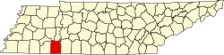
| County | Hardin |
| Elevation | 541 ft (165 m) |
| Time zone | UTC-6 (Central (CST)) |
| • Summer (DST) | UTC-5 (CDT) |
| ZIP code | 38475 [1] |
| Area code | 731 |
| GNIS feature ID | 1296412 [2] |
Olivehill, also known as Olive Hill, is an unincorporated community in Hardin County, Tennessee. Olivehill is located on U.S. Route 64 and Tennessee State Route 15, east of Savannah and west of Waynesboro.
Until the 2000 census, Olive Hill was also a census county division (CCD) for the U.S. Census. In the 2010 U.S. Census, CCDs for Tennessee were converted to minor civil divisions (MCDs) based on county commissioner districts. [3]
| Census | Pop. | Note | %± |
|---|---|---|---|
| 1980 | 2,876 | — | |
| 1990 | 3,065 | 6.6% | |
| 2000 | 3,697 | 20.6% |