Nixon, Tennessee | |
|---|---|
 Nixon  Nixon | |
| Coordinates: 35°06′53″N88°15′24″W / 35.11472°N 88.25667°W | |
| Country | United States |
| State | Tennessee |
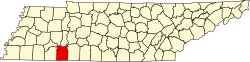
| County | Hardin |
| Area | |
• Total | 1.76 sq mi (4.57 km2) |
| • Land | 1.76 sq mi (4.57 km2) |
| • Water | 0 sq mi (0.00 km2) |
| Elevation | 499 ft (152 m) |
| Population | |
• Total | 514 |
| • Density | 291.2/sq mi (112.45/km2) |
| Time zone | UTC-6 (Central (CST)) |
| • Summer (DST) | UTC-5 (CDT) |
| ZIP code | 38372 [3] |
| Area code | 731 |
| GNIS feature ID | 1295773 [4] |
Nixon is an unincorporated community in Hardin County, Tennessee. Nixon is located on Tennessee State Route 128, north of the Tennessee River's Pickwick Landing Dam.