Crossroads, Tennessee | |
|---|---|
 Crossroads  Crossroads | |
| Coordinates: 35°17′59″N88°07′25″W / 35.29972°N 88.12361°W | |
| Country | United States |
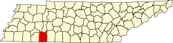
| State | Tennessee |
| County | Hardin |
| Elevation | 551 ft (168 m) |
| Time zone | UTC-6 (Central (CST)) |
| • Summer (DST) | UTC-5 (CDT) |
| Area code | 731 |
| GNIS feature ID | 1314913 [1] |
Crossroads is an unincorporated community in Hardin County, Tennessee. Crossroads is located on Tennessee State Route 128, northeast of Savannah.