Childers Hill, Tennessee | |
|---|---|
 Childers Hill  Childers Hill | |
| Coordinates: 35°04′42″N88°19′30″W / 35.07833°N 88.32500°W | |
| Country | United States |
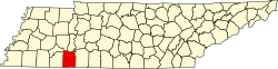
| State | Tennessee |
| County | Hardin |
| Area | |
• Total | 1.21 sq mi (3.12 km2) |
| • Land | 1.21 sq mi (3.12 km2) |
| • Water | 0.00 sq mi (0.00 km2) |
| Elevation | 525 ft (160 m) |
| Population | |
• Total | 100 |
| • Density | 82.92/sq mi (32.01/km2) |
| Time zone | UTC-6 (Central (CST)) |
| • Summer (DST) | UTC-5 (CDT) |
| Area code | 731 |
| GNIS feature ID | 1280451 [3] |
Childers Hill is an unincorporated community in Hardin County, Tennessee. Childers Hill is located south of Savannah and west of the Tennessee River.