Stantonville, Tennessee

Last updated

Stantonville, Tennessee
McNairy County Tennessee Incorporated and Unincorporated areas Stantonville Highlighted 4770840.svg
Location of Stantonville in McNairy County, Tennessee.
Coordinates: 35°9′29″N88°25′42″W / 35.15806°N 88.42833°W / 35.15806; -88.42833
Country United States
State Tennessee
County McNairy
Area
[1]
  Total1.13 sq mi (2.92 km2)
  Land1.13 sq mi (2.92 km2)
  Water0.00 sq mi (0.00 km2)
Elevation
482 ft (147 m)
Population
 (2020) [2]
  Total335
  Density296.99/sq mi (114.70/km2)
Time zone UTC-6 (Central (CST))
  Summer (DST) UTC-5 (CDT)
ZIP code
38379
Area code 731
FIPS code 47-70840 [3]
GNIS feature ID1652466 [4]

Stantonville is a town in McNairy County, Tennessee. The population was 312 at the 2000 census and 283 at the 2010 census.

Contents

Geography

Stantonville is located at 35°9′29″N88°25′42″W / 35.15806°N 88.42833°W / 35.15806; -88.42833 (35.158143, -88.428354). [5]

According to the United States Census Bureau, the town has a total area of 1.1 square miles (2.8 km2), all land.

Newspaper

Stantonville's newspaper is the Independent Appeal, which serves all of McNairy County. It was founded in 1902. It is located at 111 N. 2nd St. in Selmer.

Demographics

Historical population
CensusPop.Note
1970 296
1980 271−8.4%
1990 264−2.6%
2000 31218.2%
2010 283−9.3%
2020 33518.4%
Sources: [6] [7] [2]

As of the census [3] of 2000, there were 312 people, 122 households, and 89 families residing in the town. The population density was 282.0 inhabitants per square mile (108.9/km2). There were 137 housing units at an average density of 123.8 per square mile (47.8/km2). The racial makeup of the town was 97.44% White, 0.96% from other races, and 1.60% from two or more races. Hispanic or Latino of any race were 1.60% of the population.

There were 122 households, out of which 27.0% had children under the age of 18 living with them, 57.4% were married couples living together, 11.5% had a female householder with no husband present, and 27.0% were non-families. 23.8% of all households were made up of individuals, and 13.9% had someone living alone who was 65 years of age or older. The average household size was 2.56 and the average family size was 2.96.

In the town, the population was spread out, with 21.5% under the age of 18, 11.2% from 18 to 24, 22.8% from 25 to 44, 26.6% from 45 to 64, and 17.9% who were 65 years of age or older. The median age was 40 years. For every 100 females, there were 103.9 males. For every 100 females age 18 and over, there were 92.9 males.

The median income for a household in the town was $33,047, and the median income for a family was $34,432. Males had a median income of $21,607 versus $15,469 for females. The per capita income for the town was $13,378. About 3.3% of families and 4.7% of the population were below the poverty line, including 7.8% of those under age 18 and 5.9% of those age 65 or over.

Related Research Articles

<span class="mw-page-title-main">McNairy County, Tennessee</span> County in Tennessee, United States

McNairy County is a county located in the U.S. state of Tennessee. As of the 2020 census, the population was 25,866. Its county seat and largest city is Selmer. McNairy County is located along Tennessee's border with the state of Mississippi.

<span class="mw-page-title-main">Chester County, Tennessee</span> County in Tennessee, United States

Chester County is a county located in the U.S. state of Tennessee. As of the 2020 census, the population was 17,341. Its county seat is Henderson. The county was created in 1879 and organized in 1882. Chester County is included in the Jackson, TN Metropolitan Statistical Area.

<span class="mw-page-title-main">Trinity, Alabama</span> Town in Alabama, United States

Trinity is a town in Morgan County, Alabama, United States. It is included in the Decatur Metropolitan Area and the Huntsville-Decatur Combined Statistical Area. As of the 2020 census, the population of the town was 2,526, up from 2,095 in 2010. It was incorporated in 1901.

Deville is a census-designated place (CDP) in Rapides Parish, Louisiana, United States. It is part of the Alexandria, Louisiana Metropolitan Statistical Area. The population was 1,007 at the 2000 census.

<span class="mw-page-title-main">Scanlon, Minnesota</span> City in Minnesota, United States

Scanlon is a city in Carlton County, Minnesota, United States. The population was 987 at the 2020 census.

<span class="mw-page-title-main">Decaturville, Tennessee</span> Town in Tennessee, United States

Decaturville is a town in and the county seat of Decatur County, Tennessee, United States. The population was 867 at the 2010 census. It is named for American Revolutionary War Commodore Stephen Decatur, Jr.

<span class="mw-page-title-main">Crump, Tennessee</span> City in Tennessee, United States

Crump is a city in Hardin County, Tennessee, United States. The population was 1,428 at the 2010 census, and 1,594 at the 2020 census.

<span class="mw-page-title-main">Bethel Springs, Tennessee</span> Town in Tennessee, United States

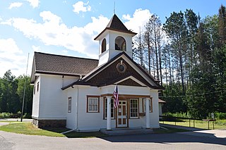
Bethel Springs is a town in McNairy County, Tennessee. The population was 998 at the 2020 census.

<span class="mw-page-title-main">Eastview, Tennessee</span> Town in Tennessee, United States

Eastview is a town in McNairy County, Tennessee. The population was 705 at the 2010 census.

<span class="mw-page-title-main">Guys, Tennessee</span> Town in Tennessee, United States

Guys is a town in McNairy County, Tennessee. The population was 466 at the 2010 census.

<span class="mw-page-title-main">Michie, Tennessee</span> Town in Tennessee, United States

Michie is a town in McNairy County, Tennessee. The population was 647 at the 2000 census and 591 at the 2010 census.

<span class="mw-page-title-main">Ramer, Tennessee</span> City in McNairy County, Tennessee, United States

Ramer is a city in McNairy County, Tennessee. The population was 354 at the 2000 census.

<span class="mw-page-title-main">Selmer, Tennessee</span> Town in Tennessee, United States

Selmer is a city in and the county seat of McNairy County, Tennessee, in the southwestern part of the state. The population was 4,396 at the 2010 census and estimated at 4,400 at the 2018 census. It is named after Selma, Alabama.

<span class="mw-page-title-main">Fairfield, Texas</span> City in Texas, United States

Fairfield is a city and county seat of Freestone County, Texas, United States. The population was 2,850 at the 2020 census, down from 3,094 at the 2000 census. It was founded in 1851.

<span class="mw-page-title-main">Huttonsville, West Virginia</span> Town in West Virginia, United States

Huttonsville is a town in Randolph County, West Virginia, United States, along the Tygart Valley River. The population was 163 at the 2020 census.

<span class="mw-page-title-main">Fern, Wisconsin</span> Town in Wisconsin, United States

Fern is a town in Florence County, Wisconsin, United States. The population was 153 at the 2000 census.

<span class="mw-page-title-main">Ridgeville, Wisconsin</span> Town in Wisconsin, United States

The Town of Ridgeville is located in Monroe County, Wisconsin, United States. The population was 491 at the 2000 census.

<span class="mw-page-title-main">Washington, Sauk County, Wisconsin</span> Town in Wisconsin, United States

Washington is a town in Sauk County, Wisconsin, United States. The population was 904 at the 2000 census. The unincorporated communities of Hill Point and Sandusky are located in the town.

<span class="mw-page-title-main">Enville, Tennessee</span> Town in Tennessee, United States

Enville is a town in Chester and McNairy counties, Tennessee, USA. The population was 230 at the 2000 census and 189 in 2010.

<span class="mw-page-title-main">Milledgeville, Tennessee</span> Town in Tennessee, United States

Milledgeville is a town in Chester, Hardin, and McNairy counties, Tennessee, United States. The population was 265 at the 2010 census.

References

  1. "ArcGIS REST Services Directory". United States Census Bureau. Retrieved October 15, 2022.
  2. 1 2 "Census Population API". United States Census Bureau. Retrieved October 15, 2022.
  3. 1 2 "U.S. Census website". United States Census Bureau . Retrieved January 31, 2008.
  4. "US Board on Geographic Names". United States Geological Survey. October 25, 2007. Retrieved January 31, 2008.
  5. "US Gazetteer files: 2010, 2000, and 1990". United States Census Bureau. February 12, 2011. Retrieved April 23, 2011.
  6. "Census of Population and Housing: Decennial Censuses". United States Census Bureau . Retrieved March 4, 2012.
  7. "Incorporated Places and Minor Civil Divisions Datasets: Subcounty Resident Population Estimates: April 1, 2010 to July 1, 2012". Population Estimates. U.S. Census Bureau. Archived from the original on June 11, 2013. Retrieved December 11, 2013.