Rutledge, Tennessee

Last updated

Rutledge, Tennessee
City of Rutledge
GraingerCountyCourthouse2020.jpg
Grainger County Courthouse in Rutledge
Grainger County Tennessee Incorporated and Unincorporated areas Rutledge Highlighted 4765820.svg
Location of Rutledge in Grainger County, Tennessee.
Coordinates: 36°16′48″N83°31′5″W / 36.28000°N 83.51806°W / 36.28000; -83.51806
Country United States
State Tennessee
County Grainger
Incorporated1797 [1]
Reincorporated1955 [2]
Named for George Rutledge
Government
[3]
  Type Mayor-aldermen
  MayorFred Sykes
  Vice MayorBenny Atkins
  Aldermen
List of Aldermen
Area
[4]
  Total5.54 sq mi (14.34 km2)
  Land5.53 sq mi (14.33 km2)
  Water0.01 sq mi (0.01 km2)
Elevation
1,017 ft (310 m)
Population
 (2020) [5]
  Total1,321
  Density238.84/sq mi (92.21/km2)
Time zone UTC-5 (Eastern (EST))
  Summer (DST) UTC-4 (EDT)
ZIP code
37861
Area code 865
FIPS code 47-65820 [6]
GNIS feature ID1269919 [7]

Rutledge is a city in and the county seat of Grainger County, Tennessee. [8] The city is part of both the Knoxville metropolitan area and the Morristown metropolitan area. [9] As of the 2020 census, the city had a total population of 1,321.

Contents

History

Downtown Rutledge, circa 1910s RutledgeTN1900s.jpg
Downtown Rutledge, circa 1910s

Rutledge was established and incorporated in 1797 and named for General George Rutledge, a prominent citizen in nearby Sullivan County. At the time of its incorporation, it became the first municipality to have its own police department in Grainger County. [10] In 1801, Rutledge became the official county seat of Grainger County, a distinction that had been shared by several communities since the county's formation in 1796. Rutledge prospered in the early 19th century in part due to its situation along the Federal Road (present day US 11W), which connected New Orleans and Virginia. The road intersected the Wilderness Road (present day US 25E) at Bean Station, just east of Rutledge. [11]

In the 1820s, President Andrew Johnson, who worked as a tailor in Greeneville, briefly operated a tailor shop in Rutledge. [12] In 1976, a replica of Johnson's tailor shop was erected on the Grainger County Courthouse lawn. [13]

During the U.S. Civil War, guerilla warfare largely paralyzed Grainger County. In December 1863, Confederate General James Longstreet, who had earlier failed to wrest Knoxville from Union forces, passed through Rutledge en route to winter quarters at Russellville. On December 14, in what became known as the Battle of Bean's Station, Longstreet attacked a Union detachment that had been pursuing him. The Confederates failed to exploit the element of surprise, and the Union forces were able to hold out until reinforcements arrived. While Longstreet was victorious, Union forces were able to retreat to fortifications at Blaine, and Longstreet subsequently abandoned the assault and continued eastward to Russellville. [14]

In May 1955, following efforts from the community's Lions Club, Rutledge would vote to reincorporate into a city in an overwhelming 192 in favor compared to 21 against incorporation. [2] Following the reincorporation, the city would construct sewage treatment and waterworks systems to promote economic development with funding given from the Eisenhower administration's Rural Development Program. [15]

Geography

Rutledge is situated near the center of Richland Valley, a narrow valley that stretches for some 35 miles (56 km) along the southern base of Clinch Mountain between Blaine and Bean Station. Richland Creek traverses most of the valley en route to its confluence along the Cherokee Lake impoundment of the Holston River, approximately 20 miles (32 km) downstream from Rutledge. Cherokee Lake's Ray Creek embayment is located approximately 10 miles (16 km) east of Rutledge.

Rutledge is centered around the junction of U.S. Route 11W, which connects the city to Kingsport to the east and Knoxville to the west, and State Route 92, which connects the city to Jefferson County, Interstate 40, and Interstate 81 to the south. U.S. Route 25E, which traverses Clinch Mountain, intersects US-11W in nearby Bean Station.

According to the United States Census Bureau, the city has a total area of 4.7 square miles (12 km2), all land.

Demographics

Historical population
CensusPop.Note
1870 107
1880 12617.8%
1890 14313.5%
1960 793
1970 8638.8%
1980 1,05822.6%
1990 903−14.7%
2000 1,18731.5%
2010 1,122−5.5%
2020 1,32117.7%
Sources: [16] [17] [5]

2020 census

Rutledge racial composition [18]
RaceNumberPercentage
White (non-Hispanic)1,23893.72%
Black or African American (non-Hispanic)100.76%
Native American 30.23%
Asian 50.38%
Pacific Islander 10.08%
Other/Mixed 453.41%
Hispanic or Latino 191.44%

As of the 2020 United States census, there were 1,321 people, 611 households, and 355 families residing in the town.

2000 census

As of the census [6] of 2000, there were 1,187 people, 475 households, and 298 families residing in the city. The population density was 253.1 inhabitants per square mile (97.7/km2). There were 530 housing units at an average density of 113.0 per square mile (43.6/km2). The racial makeup of the city was 96.88% White, 2.02% African American, 0.08% Native American, 0.08% Asian, 0.42% from other races, and 0.51% from two or more races. Hispanic or Latino of any race were 1.01% of the population.

There were 475 households, out of which 27.2% had children under the age of 18 living with them, 46.9% were married couples living together, 14.1% had a female householder with no husband present, and 37.1% were non-families. 34.7% of all households were made up of individuals, and 18.1% had someone living alone who was 65 years of age or older. The average household size was 2.17 and the average family size was 2.76.

In the city, the population was spread out, with 19.0% under the age of 18, 5.7% from 18 to 24, 28.1% from 25 to 44, 21.7% from 45 to 64, and 25.4% who were 65 years of age or older. The median age was 43 years. For every 100 females, there were 86.1 males. For every 100 females age 18 and over, there were 83.2 males.

The median income for a household in the city was $24,276, and the median income for a family was $33,571. Males had a median income of $26,151 versus $20,677 for females. The per capita income for the city was $14,477. About 11.8% of families and 20.0% of the population were below the poverty line, including 20.8% of those under the age of 18 and 31.9% of those 65 and older.

Arts and culture

Tomato Festival

Rutledge Middle School in Rutledge is the location of the Grainger County Tomato Festival, which celebrates the tomato, Grainger County's most popular cash crop, annually since 1992. Around thirty-thousand festival-goers across the state of Tennessee and the United States gather to witness events about the county's heritage and its significant agricultural impact across the state of Tennessee, enjoy live music performances, purchase local produce and handmade gifts, and take part in arts and crafts events. The Grainger County Tomato Festival takes place during the final weekend in July. [19]

Historic sites

Replica of Andrew Johnson's tailor shop Andrew-johnson-tailor-shop-tn1.jpg
Replica of Andrew Johnson's tailor shop

Notable people

Related Research Articles

<span class="mw-page-title-main">Roane County, Tennessee</span> County in Tennessee, United States

Roane County is a county of the U.S. state of Tennessee. As of the 2020 census, the population was 53,404. Its county seat is Kingston. Roane County is included in the Knoxville, TN Metropolitan Statistical Area.

<span class="mw-page-title-main">Jefferson County, Tennessee</span> County in Tennessee, United States

Jefferson County is an exurban county located in the U.S. state of Tennessee. As of the 2020 census, the population was 54,683. Its county seat is Dandridge. Jefferson County is part of the Morristown Metropolitan Statistical Area with neighboring Grainger and Hamblen counties. The county, along with the Morristown MSA, is included in the Knoxville-Morristown-Sevierville Combined Statistical Area.

<span class="mw-page-title-main">Hancock County, Tennessee</span> County in Tennessee, United States

Hancock County is a county located in the northeastern part of the U.S. state of Tennessee. As of the 2020 census, the population was 6,662, making it the fourth-least populous county in Tennessee. Its county seat is Sneedville.

<span class="mw-page-title-main">Hamblen County, Tennessee</span> County in Tennessee, United States

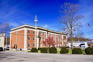
Hamblen County is a county located in the U.S. state of Tennessee. As of the 2020 census, the population was 64,499. Its county seat and only incorporated city is Morristown. Hamblen County is the core county of the Morristown, Tennessee Metropolitan Statistical Area, which includes Hamblen, Jefferson, and Grainger counties. The county and the Morristown MSA are included in the Knoxville-Morristown-Sevierville, TN Combined Statistical Area.

<span class="mw-page-title-main">Grainger County, Tennessee</span> County in Tennessee, United States

Grainger County is a county located in the U.S. state of Tennessee. As of the 2020 census, the population was 23,527. Its county seat is Rutledge. Grainger County is a part of both the Knoxville Metropolitan Statistical Area and Morristown Metropolitan Statistical Area.

<span class="mw-page-title-main">Cocke County, Tennessee</span> County in Tennessee, United States

Cocke County is a county on the eastern border of the U.S. state of Tennessee. As of the 2020 census, the population was 35,999. Its county seat is Newport. Cocke County comprises the Newport, TN Micropolitan Statistical Area, which is part of the Knoxville-Morristown-Sevierville, Tennessee Combined Statistical Area.

<span class="mw-page-title-main">Claiborne County, Tennessee</span> County in Tennessee, United States

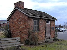
Claiborne County is a county located in the U.S. state of Tennessee. As of the 2020 census, the population was 32,043. Its county seat is Tazewell and its largest city is Harrogate.

<span class="mw-page-title-main">Blaine, Tennessee</span> Knoxville suburb and city in Grainger County, Tennessee

Blaine, formerly known as Blaine's Crossroads, is a city in Grainger County, Tennessee, United States, and a suburb of neighboring Knoxville. It is part of both the Knoxville Metropolitan Statistical Area and the Morristown Metropolitan Statistical Area. The population was 2,084 at the 2020 census.

<span class="mw-page-title-main">Dandridge, Tennessee</span> County seat of Jefferson County, Tennessee, United States

Dandridge is a town in and the county seat of Jefferson County, Tennessee. It had a population of 3,344 at the 2020 census. The town is part of the Morristown, Tennessee Metropolitan Statistical Area, which consists of Jefferson, Hamblen, and Grainger counties.

<span class="mw-page-title-main">Jefferson City, Tennessee</span> City in Jefferson County, Tennessee, United States

Jefferson City is a city in Jefferson County, Tennessee, United States. It is part of the Morristown Metropolitan Statistical Area. As of the 2020 census the population was 8,419.

<span class="mw-page-title-main">Mascot, Tennessee</span> CDP in Tennessee, United States

Mascot is a census-designated place (CDP) in Knox County, Tennessee. The population was 2,760 at the 2020 census up from 2,411 at the 2010 census.

<span class="mw-page-title-main">Morristown, Tennessee</span> Largest city and county seat of Hamblen County, Tennessee, United States

Morristown is a city in and the county seat of Hamblen County, Tennessee, United States. Morristown also extends into Jefferson County on the western and southern ends. The city lies within the Ridge and Valley of the Appalachians. The city's population was recorded to be 30,431 at the 2020 United States census. It is the principal city of the Morristown Metropolitan Statistical Area, which encompasses all of Grainger, Hamblen, and Jefferson counties. The Morristown metropolitan area is also part of the Knoxville-Morristown-Sevierville Combined Statistical Area.

<span class="mw-page-title-main">Bean Station, Tennessee</span> Lakeside town in Grainger and Hawkins counties, Tennessee

Bean Station is a town split between the counties of Grainger and Hawkins in Tennessee, United States. As of the 2020 census, the population was 2,967. It is part of the Kingsport, Knoxville, and Morristown metropolitan statistical areas.

<span class="mw-page-title-main">U.S. Route 11W</span> Suffixed section of U.S. Highway in Tennessee and Virginia in the United States

U.S. Route 11W (US 11W) is the western branch of US 11 from the twin cities of Bristol, Tennessee/Bristol, Virginia, where US 11 splits into US 11E and US 11W, to Knoxville, Tennessee, where the two highways rejoin. The highway serves the Appalachia region's Ridge-and-Valley section of East Tennessee, bounded by the Clinch Mountain ridge to the north and the Holston River to the south. US 11W from Bristol to Bean Station and Blaine to Knoxville are designated as part of the National Highway System.

<span class="mw-page-title-main">U.S. Route 25E</span> Highway in Tennessee and Kentucky, United States

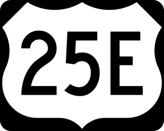
U.S. Route 25E (US 25E) is the eastern branch of US 25 from Newport, Tennessee, where US 25 splits into US 25E and US 25W, to North Corbin, Kentucky, where the two highways rejoin. The highway, however, continues as US 25E for roughly two miles (3.2 km) until it joins Interstate 75 (I-75) in the Laurel County community of North Corbin at exit 29. The highway serves the Appalachia regions of Kentucky's Cumberland Plateau and the Ridge-and-Valley section of East Tennessee, including the urbanized areas of Corbin and Middlesboro in Kentucky and Morristown in Tennessee.

<span class="mw-page-title-main">Knoxville metropolitan area</span> Metropolitan area in Tennessee, United States

The Knoxville metropolitan area, commonly known as Greater Knoxville, is a metropolitan statistical area (MSA) centered on Knoxville, Tennessee, the third largest city in Tennessee and the largest city in East Tennessee. It is the third largest metropolitan area in Tennessee. In 2020, the Knoxville metro area had a population of 879,773, and a population of 903,300 including Grainger County. The Knoxville–Morristown–Sevierville Combined Statistical Area (CSA) had a population of 1,156,861 according to the census bureau in 2020.

<span class="mw-page-title-main">Morristown metropolitan area</span> Metropolitan area based in Morristown, Tennessee, United States

The Morristown Metropolitan Statistical Area, commonly known as the Lakeway Area, as defined by the United States Census Bureau, is an area consisting of three counties - Grainger, Hamblen, and Jefferson - in eastern Tennessee, anchored by the city of Morristown. Grainger County is both in the Knoxville and Morristown Metropolitans. Including Grainger County, the 2020 census showed that the MSA had a population of 142,709.

<span class="mw-page-title-main">Joppa, Tennessee</span> Unincorporated community in Tennessee, United States

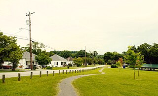
Joppa is an unincorporated community in rural central-western Grainger County, Tennessee, United States. It rests below Joppa Mountain, a subrange located near the southern terminus of the 150 mile (240 km) long Clinch Mountain ridge complex, offering views of five U.S. States and the Great Smoky Mountains. Joppa is part of the Morristown, Tennessee Metropolitan Statistical Area, and also a component of the Knoxville-Morristown-Sevierville Combined Statistical Area.

<span class="mw-page-title-main">East Tennessee Crossing Byway</span> National Scenic Byway in East Tennessee

The East Tennessee Crossing Byway is a 83-mile (134 km) National Scenic Byway in the U.S. state of Tennessee. Established in 2009, it is one of the newest byways in the National Scenic Byway system. The scenic byway traverses mostly along an unsigned concurrency of U.S. Route 25E/State Route 32 (US 25E/SR 32) in East Tennessee.

<span class="mw-page-title-main">1972 Bean Station bus-truck collision</span> Bus/semi-truck collision in Bean Station, Tennessee

The 1972 Bean Station bus-truck collision was a head-on collision involving a double-decker Greyhound bus and a tractor-trailer on U.S. Route 11W in Grainger County, Tennessee, that occurred near the town of Bean Station on the morning of May 13, 1972.

References

  1. Tennessee Blue Book , 2005-2006, pp. 618-625.
  2. 1 2 "Rutledge to Incorporate". The Rogersville Review . May 19, 1955. Retrieved June 14, 2021.
  3. University of Tennessee, Municipal Technical Advisory Service. "Rutledge". MTAS.edu. Retrieved June 22, 2020.
  4. "ArcGIS REST Services Directory". United States Census Bureau. Retrieved October 15, 2022.
  5. 1 2 "Census Population API". United States Census Bureau. Retrieved October 15, 2022.
  6. 1 2 "U.S. Census website". United States Census Bureau . Retrieved January 31, 2008.
  7. "US Board on Geographic Names". United States Geological Survey. October 25, 2007. Retrieved January 31, 2008.
  8. "Find a County". National Association of Counties. Retrieved June 7, 2011.
  9. "Revised Delineations of Metropolitan Statistical Areas, Micropolitan Statistical Areas, and Combined Statistical Areas, and Guidance on Uses of the Delineations of These Areas" (PDF). Office of Management and Budget. Retrieved April 27, 2014.
  10. Lakins, Laura (August 26, 2020). "Rutledge City Police Department has long history". Grainger Today. Retrieved September 7, 2020.
  11. Collins, Kevin (October 8, 2017). "Grainger County". Tennessee Encyclopedia . Tennessee Historical Society . Retrieved September 7, 2020.
  12. Tennessee Historical Commission Marker 1B 43 in Rutledge, Tennessee. Information accessed: February 17, 2008.
  13. Grainger County Heritage Book Committee (January 1, 1998). Grainger County, Tennessee and Its People 1796-1998. Walsworth Publishing. Retrieved August 7, 2020.
  14. "Bean's Station". CWSAC Battle Summaries. National Park Service. Archived from the original on February 23, 2008. Retrieved September 2, 2008.
  15. "Grainger Only ET County In US Farm Study Program". The Knoxville Journal. February 12, 1956. p. 7-D. Retrieved June 14, 2021.
  16. "Census of Population and Housing: Decennial Censuses". United States Census Bureau . Retrieved March 4, 2012.
  17. "Incorporated Places and Minor Civil Divisions Datasets: Subcounty Resident Population Estimates: April 1, 2010 to July 1, 2012". Population Estimates. U.S. Census Bureau. Archived from the original on June 11, 2013. Retrieved December 11, 2013.
  18. "Explore Census Data". data.census.gov. Retrieved December 27, 2021.
  19. "Grainger County Tomato Festival TN". Grainger County Tomato Festival TN. Retrieved September 7, 2020.
  20. University of Tennessee All-Americans Archived March 31, 2015, at the Wayback Machine