Ripley, Tennessee

Last updated

Ripley, Tennessee
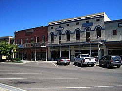
Court square Ripley TN 2013-09-14 007.jpg
City Square in Ripley, September 2013
Flag of Ripley, Tennessee.png
Logo of Ripley, Tennessee.png
Nickname(s): 
The Rip, Rip-Town, Lil' Memphis
Motto: 
"Come see what's growing on"
Lauderdale County Tennessee Incorporated and Unincorporated areas Ripley Highlighted 4763340.svg
Location of Ripley in Lauderdale County, Tennessee.
Coordinates: 35°44′35″N89°32′2″W / 35.74306°N 89.53389°W / 35.74306; -89.53389
Country United States
State Tennessee
County Lauderdale
Founded1836 [1]
Incorporated1838 [1]
Named for Eleazer Ripley [2]
Area
[3]
  Total12.91 sq mi (33.43 km2)
  Land12.87 sq mi (33.33 km2)
  Water0.04 sq mi (0.10 km2)
Elevation
[4]
446 ft (136 m)
Population
 (2020) [5]
  Total7,800
  Density606.01/sq mi (233.99/km2)
Time zone UTC-6 (Central (CST))
  Summer (DST) UTC-5 (CDT)
ZIP code
38063
Area code 731
FIPS code 47-63340 [6]
GNIS feature ID1299470 [4]
Website www.cityofripleytn.com

Ripley is a city in Lauderdale County, Tennessee, United States. The population was 8,445 at the 2010 census. It is the county seat of Lauderdale County. [7]

Contents

Geography

Ripley is located at 35°44′35″N89°32′2″W / 35.74306°N 89.53389°W / 35.74306; -89.53389 (35.743115, −89.533872). [8]

According to the United States Census Bureau, the city has a total area of 12.9 square miles (33 km2), of which 12.8 square miles (33 km2) is land and 0.04 square miles (0.10 km2) (0.31%) is water.

Ripley is located on the southeastern edge of the New Madrid Seismic Zone, an area with a high earthquake risk.

Climate

Climate data for Ripley, Tennessee (1991–2020 normals, extremes 1962–2017)
MonthJanFebMarAprMayJunJulAugSepOctNovDecYear
Record high °F (°C)77
(25)
80
(27)
86
(30)
93
(34)
96
(36)
100
(38)
105
(41)
103
(39)
100
(38)
93
(34)
86
(30)
79
(26)
105
(41)
Mean maximum °F (°C)67.5
(19.7)
72.4
(22.4)
78.8
(26.0)
85.5
(29.7)
89.8
(32.1)
95.0
(35.0)
97.1
(36.2)
96.8
(36.0)
93.0
(33.9)
86.0
(30.0)
77.9
(25.5)
67.4
(19.7)
98.1
(36.7)
Mean daily maximum °F (°C)47.7
(8.7)
53.0
(11.7)
61.1
(16.2)
71.6
(22.0)
79.9
(26.6)
87.0
(30.6)
89.8
(32.1)
88.8
(31.6)
83.4
(28.6)
73.4
(23.0)
60.1
(15.6)
51.0
(10.6)
70.6
(21.4)
Daily mean °F (°C)38.5
(3.6)
43.1
(6.2)
50.6
(10.3)
60.5
(15.8)
69.3
(20.7)
76.8
(24.9)
79.8
(26.6)
78.3
(25.7)
72.2
(22.3)
61.4
(16.3)
49.9
(9.9)
41.6
(5.3)
60.2
(15.6)
Mean daily minimum °F (°C)29.4
(−1.4)
33.2
(0.7)
40.2
(4.6)
49.4
(9.7)
58.7
(14.8)
66.7
(19.3)
69.8
(21.0)
67.9
(19.9)
61.0
(16.1)
49.5
(9.7)
39.8
(4.3)
32.3
(0.2)
49.8
(9.9)
Mean minimum °F (°C)10.7
(−11.8)
15.0
(−9.4)
24.3
(−4.3)
33.8
(1.0)
45.8
(7.7)
54.9
(12.7)
62.3
(16.8)
58.7
(14.8)
45.5
(7.5)
34.5
(1.4)
24.7
(−4.1)
14.5
(−9.7)
5.6
(−14.7)
Record low °F (°C)−10
(−23)
1
(−17)
7
(−14)
28
(−2)
33
(1)
43
(6)
49
(9)
50
(10)
33
(1)
25
(−4)
11
(−12)
−8
(−22)
−10
(−23)
Average precipitation inches (mm)4.15
(105)
4.80
(122)
5.10
(130)
5.11
(130)
7.20
(183)
4.94
(125)
4.52
(115)
3.61
(92)
3.50
(89)
4.06
(103)
4.57
(116)
5.28
(134)
56.84
(1,444)
Average snowfall inches (cm)0.9
(2.3)
0.4
(1.0)
1.1
(2.8)
0.0
(0.0)
0.0
(0.0)
0.0
(0.0)
0.0
(0.0)
0.0
(0.0)
0.0
(0.0)
0.0
(0.0)
0.0
(0.0)
0.0
(0.0)
2.4
(6.1)
Average precipitation days (≥ 0.01 in)8.67.810.410.010.78.38.17.06.38.08.09.7102.9
Average snowy days (≥ 0.1 in)0.80.30.40.00.00.00.00.00.00.00.00.41.9
Source 1: NOAA [9]
Source 2: XMACIS2 (mean maxima/minima 19812010) [10]

Demographics

Historical population
CensusPop.Note
1870 532
1880 353−33.6%
1890 68293.2%
1900 1,640140.5%
1910 2,01122.6%
1920 2,0702.9%
1930 2,33012.6%
1940 2,78419.5%
1950 3,31819.2%
1960 3,78214.0%
1970 4,79426.8%
1980 6,36632.8%
1990 6,188−2.8%
2000 7,84426.8%
2010 8,4457.7%
2020 7,800−7.6%
Sources: [11] [12] [5]

2020 Census

Ripley, Tennessees – Racial and ethnic composition
Note: the US Census treats Hispanic/Latino as an ethnic category. This table excludes Latinos from the racial categories and assigns them to a separate category. Hispanics/Latinos may be of any race.
Race / Ethnicity (NH = Non-Hispanic)Pop 2000 [13] Pop 2010 [14] Pop 2020 [15] % 2000% 2010% 2020
White alone (NH)4,0153,6302,75851.19%42.98%35.36%
Black or African American alone (NH)3,6494,5124,57546.52%53.43%58.65%
Native American or Alaska Native alone (NH)1213190.15%0.15%0.24%
Asian alone (NH)2133340.27%0.39%0.44%
Pacific Islander alone (NH)0000.00%0.00%0.00%
Some Other Race alone (NH)14880.18%0.09%0.10%
Mixed Race or Multi-Racial (NH)491152240.62%1.36%2.87%
Hispanic or Latino (any race)841341821.07%1.59%2.33%
Total7,8448,4457,800100.00%100.00%100.00%

As of the 2020 United States census, there were 7,800 people, 3,269 households, and 2,097 families residing in the city.

2000 census

As of the census [6] of 2000, there were 7,844 people, 3,142 households, and 2,054 families residing in the city. The population density was 612.3 inhabitants per square mile (236.4/km2). There were 3,397 housing units at an average density of 265.2 per square mile (102.4/km2). The racial makeup of the city was 51.56% White, 46.81% African American, 0.15% Native American, 0.27% Asian, 0.38% from other races, and 0.83% from two or more races. Hispanic or Latino of any race were 1.07% of the population.

There were 3,142 households, out of which 32.1% had children under the age of 18 living with them, 38.1% were married couples living together, 23.5% had a female householder with no husband present, and 34.6% were non-families. 31.0% of all households were made up of individuals, and 12.9% had someone living alone who was 65 years of age or older. The average household size was 2.44 and the average family size was 3.06.

In the city, the population was spread out, with 27.6% under the age of 18, 11.0% from 18 to 24, 27.2% from 25 to 44, 20.2% from 45 to 64, and 14.0% who were 65 years of age or older. The median age was 34 years. For every 100 females, there were 84.7 males. For every 100 females age 18 and over, there were 78.3 males.

The median income for a household in the city was $23,662, and the median income for a family was $34,183. Males had a median income of $31,321 versus $20,661 for females. The per capita income for the city was $13,710. About 22.1% of families and 27.2% of the population were below the poverty line, including 38.1% of those under age 18 and 27.5% of those age 65 or over.
Education

All parts of the county are in the Lauderdale County School District. [16]

Public K-12 schools:

Other institutions:

Tertiary:

Religion

Recreation and fitness

Ripley Parks and Recreation

Ripley Park, also known as Ripley Pool and Waterslide, is located at 200 Mary Robert. Its facilities include: a pool with water slide, playground equipment, seven pavilions that require reservations, grills, four athletic field complex, four state of the art tennis courts, 1.1 mile walking trail, large grassy areas parking, restrooms, and the park office.

W.G.L. Rice Park is located south of downtown Ripley, Tennessee. The park has a baseball/softball field, soccer field, tennis court, basketball court, two playgrounds, and a partial walking trail. Rice Park is the oldest city park in Ripley. The land for the park was donated in the early 1900s through a gift by the Rice Family and is noted for its historic Labor Day Celebration.

Downtown revitalization

As one of the six cities selected in Tennessee for downtown revitalization, extensive work is being done around the town square and adjacent areas. Work began in the fall of 2008 and the courthouse square was completed in May 2010.

Notable people

Related Research Articles

<span class="mw-page-title-main">Lamar County, Alabama</span> County in Alabama, United States

Lamar County is a county in the U.S. state of Alabama. As of the 2020 census, the population was 13,972. Its county seat is Vernon and it is a dry county. It is named in honor of Lucius Quintus Cincinnatus Lamar, a former Confederate officer and former member of both houses of the United States Congress from Mississippi.

<span class="mw-page-title-main">Lauderdale County, Alabama</span> County in Alabama, United States

Lauderdale County is a county located in the northwestern corner of the U.S. state of Alabama. At the 2020 census the population was 93,564. Its county seat is Florence. Its name is in honor of Colonel James Lauderdale, of Tennessee. Lauderdale is part of the Florence-Muscle Shoals, AL Metropolitan Statistical Area, also known as "The Shoals".

<span class="mw-page-title-main">Marshall County, Alabama</span> County in Alabama, United States

Marshall County is a county of the state of Alabama, United States. As of the 2020 census the population was 97,612. Its county seat is Guntersville. A second courthouse is in Albertville. Its name is in honor of John Marshall, famous Chief Justice of the United States. Marshall County is a dry county, with the exception of the five cities of Albertville, Arab, Grant, Guntersville, and Boaz. Marshall County comprises the Albertville, AL Micropolitan Statistical Area, which is also included in the Huntsville-Decatur-Albertville, AL Combined Statistical Area.

<span class="mw-page-title-main">Tallapoosa County, Alabama</span> County in Alabama, United States

Tallapoosa County is a county located in the east-central portion of the U.S. state of Alabama. As of the 2020 census, the population was 41,311. Its county seat is Dadeville. Its largest city is Alexander City.

<span class="mw-page-title-main">Wayne County, Tennessee</span> County in Tennessee, United States

Wayne County is a county located in south central Tennessee, along the Alabama border. As of the 2020 census, the population was 16,232. Its county seat is Waynesboro. The county is named after General "Mad Anthony" Wayne, a prominent military leader in the American Revolutionary War.

<span class="mw-page-title-main">Madison County, Tennessee</span> County in Tennessee, United States

Madison County is a county located in the western part of the U.S. state of Tennessee. As of the 2020 census, the population was 98,823. Its county seat is Jackson. Madison County is included in the Jackson, TN Metropolitan Statistical Area.

<span class="mw-page-title-main">Lauderdale County, Tennessee</span> County in Tennessee, United States

Lauderdale County is a county located on the western edge of the U.S. state of Tennessee, with its border the Mississippi River. As of the 2020 census, the population was 25,143. Its county seat is Ripley. Since the antebellum years, it has been developed for cotton as a major commodity crop.

<span class="mw-page-title-main">Ripley County, Missouri</span> County in Missouri, United States

Ripley County is a county in the Ozarks of Missouri. At the 2020 census, it had a population of 10,679. The largest city and county seat is Doniphan. The county was officially organized on January 5, 1833, and is named after Brigadier General Eleazer Wheelock Ripley, a soldier who served with distinction in the War of 1812.

<span class="mw-page-title-main">Catoosa County, Georgia</span> County in Georgia, United States

Catoosa County is a county located in the northwestern part of the U.S. state of Georgia. According to the 2020 census, the population was 67,872. The county seat is Ringgold. The county was created on December 5, 1853. The meaning of the Cherokee language name "Catoosa" is obscure. "Catoosa" may come from the Cherokee words gatusi or gatu'gitse.

<span class="mw-page-title-main">Rogersville, Alabama</span> Town in Alabama, United States

Rogersville is a town in Lauderdale County, Alabama, United States. As of the 2018 census, the population of the town is 1,231, up from 1,199 in 2000.

<span class="mw-page-title-main">Lauderdale Lakes, Florida</span> City in Florida

Lauderdale Lakes is a city in Broward County, Florida, United States. It is part of the Miami metropolitan area of South Florida. As of the 2020 United States Census, the city's population was 35,954.

<span class="mw-page-title-main">Lauderhill, Florida</span> City in Florida, United States

Lauderhill is a city in Broward County, Florida, United States. It is a principal city of the Miami metropolitan area. As of the 2020 census, the city's population was 74,482.

<span class="mw-page-title-main">Citrus Park, Florida</span> Census-designated place in Florida, United States

Citrus Park is an unincorporated census-designated place in Hillsborough County, Florida, United States. The population was 28,178 at the 2020 census, up from 24,252 at the 2010 census.

<span class="mw-page-title-main">Streamwood, Illinois</span> Village in Illinois, United States

Streamwood is a village in Cook County, Illinois, United States. Per the 2020 census, the population was 39,577. It is a northwest suburb of Chicago, and is a part of the Chicago metropolitan area.

<span class="mw-page-title-main">Lauderdale, Minnesota</span> City in Minnesota, United States

Lauderdale is a city in Ramsey County, Minnesota, United States. The population was 2,379 at the 2010 census. Lauderdale is part of the Minneapolis–St. Paul metropolitan area and is bordered by Minneapolis, St. Paul, Roseville, and Falcon Heights. Along with Roseville, it is one of two cities to be bordered directly by Minneapolis and St. Paul.

<span class="mw-page-title-main">Rockwell, North Carolina</span> Town in North Carolina, United States

Rockwell is a town in Rowan County, North Carolina, United States. The population was 2,302 at the 2020 census.

<span class="mw-page-title-main">Minor Hill, Tennessee</span> City in Tennessee, United States

Minor Hill is a city in Giles County, Tennessee, United States. The population was 537 at the 2010 census.

<span class="mw-page-title-main">Bolivar, Tennessee</span> City in Tennessee, United States

Bolivar is a city in and the county seat of Hardeman County, Tennessee, United States. The town was named for South American revolutionary leader Simón Bolívar. As of the 2010 census, the city population was 5,417.

<span class="mw-page-title-main">Gates, Tennessee</span> Town in Tennessee, United States

Gates is a town in Lauderdale County, Tennessee, United States. The population was 901 at the 2000 census and 647 at the 2010 census, showing a decline of 254.

<span class="mw-page-title-main">Halls, Tennessee</span> Town in Tennessee, United States

Halls is a town in Lauderdale County, Tennessee, United States. The population was 2,255 at the 2010 census.

References

  1. 1 2 Paul Hellman, Historical Gazetteer of the United States (Taylor and Francis, 2005), p. 1025.
  2. Nancy Capace, Encyclopedia of Tennessee (North American Book Distributors, 2000), p. 214.
  3. "ArcGIS REST Services Directory". United States Census Bureau. Retrieved October 15, 2022.
  4. 1 2 U.S. Geological Survey Geographic Names Information System: Ripley, Tennessee
  5. 1 2 "Census Population API". United States Census Bureau. Retrieved October 15, 2022.
  6. 1 2 "U.S. Census website". United States Census Bureau . Retrieved January 31, 2008.
  7. "Find a County". National Association of Counties. Retrieved June 7, 2011.
  8. "US Gazetteer files: 2010, 2000, and 1990". United States Census Bureau. February 12, 2011. Retrieved April 23, 2011.
  9. "U.S. Climate Normals Quick Access – Station: Ripley, TN". National Oceanic and Atmospheric Administration. Retrieved June 16, 2023.
  10. "xmACIS2". National Oceanic and Atmospheric Administration. Retrieved June 16, 2023.
  11. "Census of Population and Housing: Decennial Censuses". United States Census Bureau . Retrieved March 4, 2012.
  12. "Incorporated Places and Minor Civil Divisions Datasets: Subcounty Resident Population Estimates: April 1, 2010 to July 1, 2012". Population Estimates. U.S. Census Bureau. Archived from the original on June 11, 2013. Retrieved December 11, 2013.
  13. "P004 Hispanic or Latino, and Not Hispanic or Latino by Race – 2000: DEC Summary File 1 – Ripley city, Tennessee". United States Census Bureau .
  14. "P2 Hispanic or Latino, and Not Hispanic or Latino by Race – 2010: DEC Redistricting Data (PL 94-171) – Ripley city, Tennessee". United States Census Bureau .
  15. "P2 Hispanic or Latino, and Not Hispanic or Latino by Race – 2020: DEC Redistricting Data (PL 94-171) – Ripley city, Tennessee". United States Census Bureau .
  16. "2020 CENSUS - SCHOOL DISTRICT REFERENCE MAP: Lauderdale County, TN" (PDF). U.S. Census Bureau . Retrieved January 20, 2023. - Text list