Charlotte, Tennessee

Last updated

Charlotte, Tennessee
Charlotte Tennessee City Hall 09-04-2016.jpg
City Hall in Charlotte
Dickson County Tennessee Incorporated and Unincorporated areas Charlotte Highlighted 4713080.svg
Location of Charlotte in Dickson County, Tennessee.
Coordinates: 36°10′44″N87°20′39″W / 36.17889°N 87.34417°W / 36.17889; -87.34417
Country United States
State Tennessee
County Dickson
Founded1808
Incorporated1817
Named for Charlotte Reeves Robertson
Area
[1]
  Total4.06 sq mi (10.51 km2)
  Land4.06 sq mi (10.51 km2)
  Water0.00 sq mi (0.00 km2)
Elevation
[2]
650 ft (200 m)
Population
 (2020) [3]
  Total1,656
  Density408.08/sq mi (157.55/km2)
Time zone UTC-6 (Central (CST))
  Summer (DST) UTC-5 (CDT)
ZIP code
37036
Area code 615
FIPS code 47-13080 [4]
GNIS feature ID1305868 [2]

Charlotte is a town in Dickson County, Tennessee, United States. The population was 1,656 at the 2020 census. [5] It is the county seat of Dickson County. [6] This town is part of the Nashville metropolitan area.

Contents

History

Charlotte was established in 1804 by an act of the state legislature as the county seat for Dickson County, which had been created in 1803. The town was named for Charlotte Reeves Robertson, the wife of General James Robertson, who played prominent roles in the settlement of Middle Tennessee. Charlotte was officially incorporated in 1837. [7]

On May 30, 1830, a tornado destroyed most of downtown Charlotte. The roof of the courthouse was found 13 miles (21 km) away, and most of the county's early records were permanently lost. A new courthouse was completed in 1833, and still stands as the oldest functioning courthouse in the state of Tennessee. [7] While Charlotte thrived as a stage coach hub for much of the 19th-century, the arrival of the railroad in the latter half of the century shifted the area's industrial focus to Dickson, several miles to the southwest. [7]

Geography

Charlotte is located at 36°10′44″N87°20′39″W / 36.17889°N 87.34417°W / 36.17889; -87.34417 (36.178784, -87.344304). [8] The town is situated amidst the hills that comprise part of the western section of the Highland Rim, nearly halfway between Dickson and Ashland City. A small stream known as Town Branch, which is part of the Cumberland River watershed, flows through Charlotte from west to east.

Charlotte is centered around the junction of State Route 49, which connects Charlotte with Ashland City and Kentucky to the northeast and upper West Tennessee to the northwest, and State Route 48, which connects the town to Dickson and U.S. Route 70 to the southwest and Clarksville to the north. These road intersections are just west of the court square.

According to the United States Census Bureau, the town has a total area of 1.7 square miles (4.4 km2), all land.

Climate

The climate in this area is characterized by hot, humid summers and generally mild to cool winters. According to the Köppen Climate Classification system, Charlotte has a humid subtropical climate, abbreviated "Cfa" on climate maps. [9]

Climate data for Charlotte, Tennessee, 1991–2020 normals, extremes 2006present
MonthJanFebMarAprMayJunJulAugSepOctNovDecYear
Record high °F (°C)76
(24)
80
(27)
85
(29)
89
(32)
91
(33)
103
(39)
106
(41)
106
(41)
100
(38)
96
(36)
86
(30)
76
(24)
106
(41)
Mean daily maximum °F (°C)46.9
(8.3)
50.9
(10.5)
59.6
(15.3)
69.7
(20.9)
77.0
(25.0)
84.4
(29.1)
87.6
(30.9)
87.3
(30.7)
81.2
(27.3)
71.9
(22.2)
58.9
(14.9)
49.2
(9.6)
68.7
(20.4)
Daily mean °F (°C)36.9
(2.7)
40.1
(4.5)
48.2
(9.0)
57.5
(14.2)
65.5
(18.6)
73.6
(23.1)
76.9
(24.9)
76.1
(24.5)
69.4
(20.8)
58.9
(14.9)
47.5
(8.6)
39.2
(4.0)
57.5
(14.2)
Mean daily minimum °F (°C)26.8
(−2.9)
29.2
(−1.6)
36.9
(2.7)
45.3
(7.4)
54.1
(12.3)
62.8
(17.1)
66.3
(19.1)
64.9
(18.3)
57.5
(14.2)
45.9
(7.7)
36.0
(2.2)
29.3
(−1.5)
46.2
(7.9)
Record low °F (°C)−4
(−20)
−2
(−19)
0
(−18)
18
(−8)
30
(−1)
44
(7)
50
(10)
50
(10)
35
(2)
25
(−4)
10
(−12)
−2
(−19)
−4
(−20)
Average precipitation inches (mm)4.16
(106)
4.99
(127)
4.45
(113)
5.06
(129)
5.64
(143)
3.96
(101)
4.47
(114)
3.30
(84)
3.61
(92)
3.62
(92)
3.83
(97)
4.95
(126)
52.04
(1,324)
Source 1: NOAA [10]
Source 2: XMACIS2 [11]

Education

Demographics

Historical population
CensusPop.Note
1870 276
1890 427
1910 236
1920 200−15.3%
1930 29145.5%
1940 47061.5%
1950 4781.7%
1960 55115.3%
1970 61010.7%
1980 78829.2%
1990 8548.4%
2000 1,15335.0%
2010 1,2357.1%
2020 1,65634.1%
Sources: [12] [13] [3]

2020 census

Charlotte racial composition [14]
RaceNumberPercentage
White (non-Hispanic)1,44887.44%
Black or African American (non-Hispanic)1106.64%
Native American 20.12%
Asian 50.3%
Other/Mixed 422.54%
Hispanic or Latino 492.96%

As of the 2020 United States census, there were 1,656 people, 537 households, and 329 families residing in the town.

2000 census

As of the census [4] of 2000, there were 1,153 people, 395 households, and 272 families residing in the town. The population density was 661.0 inhabitants per square mile (255.2/km2). There were 413 housing units at an average density of 236.8 per square mile (91.4/km2). The racial makeup of the town was 86.82% White, 10.67% African American, 0.35% Native American, 0.17% Asian, 0.09% Pacific Islander, 0.26% from other races, and 1.65% from two or more races. Hispanic or Latino of any race were 1.21% of the population.

The Voorhies-James House in Charlotte, built in 1806 Voorhies-james-house-tn1.jpg
The Voorhies-James House in Charlotte, built in 1806

There were 395 households, out of which 30.1% had children under the age of 18 living with them, 52.2% were married couples living together, 11.9% had a female householder with no husband present, and 31.1% were non-families. 26.8% of all households were made up of individuals, and 12.4% had someone living alone who was 65 years of age or older. The average household size was 2.50 and the average family size was 3.03.

In the town, the population was spread out, with 21.9% under the age of 18, 10.0% from 18 to 24, 35.5% from 25 to 44, 20.3% from 45 to 64, and 12.3% who were 65 years of age or older. The median age was 34 years. For every 100 females, there were 111.9 males. For every 100 females age 18 and over, there were 120.0 males.

The median income for a household in the town was $32,279, and the median income for a family was $40,795. Males had a median income of $30,172 versus $21,442 for females. The per capita income for the town was $15,061. About 7.0% of families and 10.6% of the population were below the poverty line, including 18.4% of those under age 18 and 14.4% of those age 65 or over.

Notable person

Related Research Articles

<span class="mw-page-title-main">Humphreys County, Tennessee</span> County in Tennessee, United States

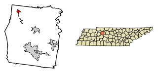
Humphreys County is a county located in the western part of Middle Tennessee, in the U.S. state of Tennessee. As of the 2020 census, the population was 18,990. Its county seat is Waverly.

<span class="mw-page-title-main">Dickson County, Tennessee</span> County in Tennessee, United States

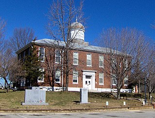
Dickson County is a county located in the U.S. state of Tennessee. As of the 2020 census, the population was 54,315. Its county seat is Charlotte. Dickson County is part of the Nashville-Davidson–Murfreesboro–Franklin, TN Metropolitan Statistical Area. Dickson County is home to Tennessee's oldest courthouse in continuous use, built in 1835. This is the second courthouse in Charlotte as the first one, a log building, was destroyed in the Tornado of 1833, which destroyed all but one building on the courthouse square.

<span class="mw-page-title-main">Cheatham County, Tennessee</span> County in Tennessee, United States

Cheatham County is a county located in the U.S. state of Tennessee. As of the 2020 census, the population was 41,072. Its county seat is Ashland City. Cheatham County is located in Middle Tennessee, and is part of the Nashville-Davidson–Murfreesboro–Franklin, TN Metropolitan Statistical Area.

<span class="mw-page-title-main">Hartwick, Iowa</span> City in Iowa, United States

Hartwick is a city in Poweshiek County, Iowa, United States. The population was 92 at the time of the 2020 census.

Port Leyden is a village in Lewis County, New York, United States. The population was 672 at the 2010 census. The name is derived from the village's early history as a port on the Black River Canal.

<span class="mw-page-title-main">Fairless Hills, Pennsylvania</span> Census-designated place in Pennsylvania, United States

Fairless Hills is a census-designated place (CDP) in Bucks County, Pennsylvania, United States. The CDP is located within c. The population was 9,046 at the 2020 census. That is up from 8,466 at the 2010 census.

<span class="mw-page-title-main">Carbon Township, Pennsylvania</span> Township in Pennsylvania, United States

Carbon Township is a township in Huntingdon County, Pennsylvania, United States. As of the 2020 census, the township population was 316.

<span class="mw-page-title-main">Tazewell, Tennessee</span> Town in Tennessee, United States

Tazewell is a town in and the county seat of Claiborne County, Tennessee, United States. The population was 2,165 at the 2000 census, 2,218 at the 2010 census, and 2,348 at the 2020 census. The town is named for Tazewell, Virginia, which itself was named for Henry Tazewell (1753–1799), a U.S. senator from Virginia.

<span class="mw-page-title-main">Burns, Tennessee</span> Town in Tennessee, United States

Burns is a town in Dickson County, Tennessee, in the United States. It is part of the Nashville-Davidson–Murfreesboro–Franklin, TN Metropolitan Statistical Area. The population was 1,468 at the 2010 census.

<span class="mw-page-title-main">Dickson, Tennessee</span> City in Tennessee, United States

Dickson is a city in the U.S. state of Tennessee. Located in Dickson County. It is part of the Nashville metropolitan area. As of the 2020 census, Dickson's population was 16,058.

<span class="mw-page-title-main">Slayden, Tennessee</span> Town in Tennessee, United States

Slayden is a town in Dickson County, Tennessee, United States. The population was 178 at the 2010 census.

<span class="mw-page-title-main">Vanleer, Tennessee</span> Town in Tennessee, United States

Vanleer is a town in Dickson County, Tennessee, United States. The population was estimated to be 422 in 2019, up from 395 at the 2010 census. The town is approximately 49 miles northwest of Nashville and is located within the city's greater metropolitan area.

<span class="mw-page-title-main">White Bluff, Tennessee</span> Town in Tennessee, United States

White Bluff is a town in Dickson County, Tennessee, United States. The population was 3,862 at the 2020 census and 3,206 at the 2010 census. The community name derives from the White Bluff Iron Forge.

<span class="mw-page-title-main">Waverly, Tennessee</span> City in Tennessee, United States

Waverly is a city in and the county seat of Humphreys County, Tennessee, United States. The population was 4,297 at the 2020 census.

<span class="mw-page-title-main">Cumberland City, Tennessee</span> Town in Tennessee, United States

Cumberland City is a town in Stewart County, Tennessee. The population was 311 at the 2010 census. It is part of the Clarksville, TN — Kentucky Metropolitan Statistical Area.

<span class="mw-page-title-main">Dover, Tennessee</span> City in Tennessee, United States

Dover is a city in and the county seat of Stewart County, Tennessee, 67 miles (108 km) west-northwest of Nashville on the Cumberland River. Fort Donelson National Cemetery is in Dover. The population was 1,442 at the 2000 census and the 2010 census showed a population of 1,417.

<span class="mw-page-title-main">Comanche, Texas</span> Community in Texas, United States

Comanche is a city located in Comanche County in the U.S. state of Texas. The population was 4,335 at the 2010 census. It is the county seat of Comanche County.

<span class="mw-page-title-main">Mineralwells, West Virginia</span> CDP in West Virginia, United States

Mineralwells, also known as Mineral Wells, is a census-designated place (CDP) in Wood County, West Virginia, United States. It is part of the Parkersburg-Marietta-Vienna, WV-OH Metropolitan Statistical Area. The population was 1,950 at the 2010 census. The population was 2216 at the 2021 census.

<span class="mw-page-title-main">El Paso, Wisconsin</span> Town in Wisconsin, United States

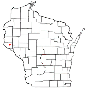
El Paso is a town in Pierce County, Wisconsin, United States. The population was 690 at the 2000 census. The unincorporated community of El Paso is located in the town. The unincorporated community of Waverly is also located partially in the town.

<span class="mw-page-title-main">Tennessee Ridge, Tennessee</span> Town in Tennessee, United States

Tennessee Ridge is a town in Houston and Stewart counties in the U.S. state of Tennessee. The population was 1,332 at the 2020 census and 1,368 at the 2010 census.

References

  1. "ArcGIS REST Services Directory". United States Census Bureau. Retrieved October 15, 2022.
  2. 1 2 U.S. Geological Survey Geographic Names Information System: Charlotte, Tennessee
  3. 1 2 "Census Population API". United States Census Bureau. Retrieved October 15, 2022.
  4. 1 2 "U.S. Census website". United States Census Bureau . Retrieved January 31, 2008.
  5. Tennessee Department of Economic and Community Development, Certified Population of Tennessee Incorporated Municipalities and Counties Archived June 30, 2014, at the Wayback Machine , State of Tennessee official website, July 14, 2011. Retrieved: December 6, 2013.
  6. "Find a County". National Association of Counties. Archived from the original on May 31, 2011. Retrieved June 7, 2011.
  7. 1 2 3 Rick Hollis, "A Brief History of Dickson County, Tennessee Archived May 13, 2008, at the Wayback Machine ," 4-5. Retrieved: February 11, 2008.
  8. "US Gazetteer files: 2010, 2000, and 1990". United States Census Bureau. February 12, 2011. Retrieved April 23, 2011.
  9. Climate Summary for Charlotte, Tennessee
  10. "U.S. Climate Normals Quick Access – Station: Charlotte, TN". National Oceanic and Atmospheric Administration. Retrieved May 11, 2023.
  11. "xmACIS2". National Oceanic and Atmospheric Administration. Retrieved May 11, 2023.
  12. "Census of Population and Housing: Decennial Censuses". United States Census Bureau . Retrieved March 4, 2012.
  13. "Incorporated Places and Minor Civil Divisions Datasets: Subcounty Resident Population Estimates: April 1, 2010 to July 1, 2012". Population Estimates. U.S. Census Bureau. Archived from the original on June 11, 2013. Retrieved December 11, 2013.
  14. "Explore Census Data". data.census.gov. Retrieved December 27, 2021.

36°10′44″N87°20′39″W / 36.178784°N 87.344304°W / 36.178784; -87.344304