Slayden, Tennessee

Last updated

Slayden, Tennessee
Dickson County Tennessee Incorporated and Unincorporated areas Slayden Highlighted 4769080.svg
Location of Slayden in Dickson County, Tennessee.
Coordinates: 36°17′39″N87°28′14″W / 36.29417°N 87.47056°W / 36.29417; -87.47056
Country United States
State Tennessee
County Dickson
Area
[1]
  Total1.53 sq mi (3.97 km2)
  Land1.53 sq mi (3.97 km2)
  Water0.00 sq mi (0.00 km2)
Elevation
[2]
735 ft (224 m)
Population
 (2020) [3]
  Total170
  Density110.89/sq mi (42.82/km2)
Time zone UTC-6 (Central (CST))
  Summer (DST) UTC-5 (CDT)
ZIP code
37165
Area code 615
FIPS code 47-69080 [4]
GNIS feature ID1303663 [2]

Slayden is a town in Dickson County, Tennessee, United States. The population was 178 at the 2010 census. [5]

Contents

Geography

Slayden is located in northwestern Dickson County at 36°17′39″N87°28′14″W / 36.29417°N 87.47056°W / 36.29417; -87.47056 (36.294208, -87.470514). [6] Tennessee State Route 235 passes through the town, leading northeast 10 miles (16 km) to Cunningham and south 18 miles (29 km) to Dickson.

According to the United States Census Bureau, Slayden has a total area of 1.4 square miles (3.5 km2), all land. [5]

Demographics

Historical population
CensusPop.Note
1920 158
1930 1622.5%
1940 1641.2%
1950 90−45.1%
1960 10112.2%
1970 95−5.9%
1980 69−27.4%
1990 11160.9%
2000 18566.7%
2010 178−3.8%
2020 170−4.5%
Sources: [7] [8] [3]

As of the census [4] of 2000, there were 185 people, 79 households, and 54 families residing in the town. The population density was 341.7 inhabitants per square mile (131.9/km2). There were 86 housing units at an average density of 158.9 per square mile (61.4/km2). The racial makeup of the town was 97.30% White, 0.54% African American, 1.62% Native American, and 0.54% from two or more races.

There were 79 households, of which 25.3% had children under the age of 18 living with them, 59.5% were married couples living together, 5.1% had a female householder with no husband present, and 30.4% were non-families. 27.8% of all households were made up of individuals, and 17.7% had someone living alone who was 65 years of age or older. The average household size was 2.34 and the average family size was 2.80.

In the town, the population was spread out, with 19.5% under the age of 18, 5.9% from 18 to 24, 29.2% from 25 to 44, 27.6% from 45 to 64, and 17.8% who were 65 years of age or older. The median age was 43 years. For every 100 females, there were 110.2 males. For every 100 females age 18 and over, there were 109.9 males.

The median income for a household in the town was $36,071, and the median income for a family was $46,042. Males had a median income of $25,417 versus $23,125 for females. The per capita income for the town was $20,189. About 8.2% of families and 9.7% of the population were below the poverty line, including none of those under the age of eighteen and 14.3% of those sixty-five or over.

History

Slayden's growth was spurred by the existence of a railroad line (the "Mineral Branch" of the Louisville and Nashville Railroad) which was built in the late 19th century largely to assist the movement of iron from the nearby works at Cumberland Furnace to market. In the early 20th century Slayden was home to a department store and was considered a major community of Dickson County. With the closure of the Mineral Branch and the Cumberland Furnace works, the area went into an economic decline. As the area declined from the loss of the furnace works, nearby Nashville and Clarksville offered more non-farming opportunities. The local primary school was closed in 1960 and merged with the larger one in nearby Vanleer. At about this time mail ceased to be delivered from the post office, which continues to serve post office boxholders.

In the 1980 census, Slayden had only 69 inhabitants and was known for the next decade as Tennessee's smallest incorporated town. In the 1980s the former railroad depot was removed to Hickman County to become an attraction at a proposed amusement park honoring Minnie Pearl that never actually came into operation. The voting precinct in the area was abolished after the 2000 elections and split between those in Vanleer and Cumberland Furnace. In 2003 the town's future as an incorporated community seemed endangered when only six voters (out of 127 registered) participated in a municipal election and only two candidates qualified for the four unpaid positions on the Board of Mayor and Aldermen. This was prevented when the vacancies were filled by persons who had received write-in votes; participation in the 2005 municipal elections was considerably higher.

The Slayden family appears in the census for Dickson County in 1820, 1830 and 1840, by which time there were four Slayden heads of household, all being descended from brothers Daniel Everett Slayden and William Everett Slayden. Both lines produced a prodigious number of military officers, medical doctors, or dentists. One son of Daniel Everett Slayden was Hartwell Marable Slayden, born ca. 1806, who had three sons who were medical doctors: William Marshall Slayden, John Dann Slayden and Hartwell Marable Slayden Jr. All three sons of Hartwell M. are in the 1850 Dickson County census, along with one of the patriarchs "William Everette Slayden" listed as a "waggonmaker" born 1788 in Virginia, and four other heads of households. The name of the community probably reflects the land ownership (possibly plantations) of this family, as the 1860 census reveals 35 "white" members of this extended family, and there are also slaves on the 1860 Slave Schedules. Alternatively, it could reflect the service of the three physicians to the community. The Slayden Cemetery (sometimes called Guerin Cemetery, an allied family) holds many members of this family. The name continued into the 1930 census. Most other lines of this family (cousinage proven by DNA) now use "Slayton" or "Slaton" as name spelling, though a few "Slayden"s are still found in parts of Tennessee and Florida.

Related Research Articles

<span class="mw-page-title-main">Montgomery County, Tennessee</span> County in Tennessee, United States

Montgomery County is a county in the U.S. state of Tennessee. As of the 2020 United States census, the population was 220,069. The county seat is Clarksville. The county was created in 1796. Montgomery County is included in the Clarksville, TN–KY Metropolitan Statistical Area.

<span class="mw-page-title-main">Humphreys County, Tennessee</span> County in Tennessee, United States

Humphreys County is a county located in the western part of Middle Tennessee, in the U.S. state of Tennessee. As of the 2020 census, the population was 18,990. Its county seat is Waverly.

<span class="mw-page-title-main">Hickman County, Tennessee</span> County in Tennessee, United States

Hickman County is a county located in the U.S. state of Tennessee. As of the 2020 Census, the population was 24,925. Its county seat is Centerville. As of 2023, Hickman County is part of the Nashville–Davidson–Murfreesboro–Franklin, TN Metropolitan Statistical Area, although it was once removed in 2018.

<span class="mw-page-title-main">Dickson County, Tennessee</span> County in Tennessee, United States

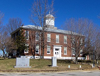
Dickson County is a county located in the U.S. state of Tennessee. As of the 2020 census, the population was 54,315. Its county seat is Charlotte. Dickson County is part of the Nashville-Davidson–Murfreesboro–Franklin, TN Metropolitan Statistical Area. Dickson County is home to Tennessee's oldest courthouse in continuous use, built in 1835. This is the second courthouse in Charlotte as the first one, a log building, was destroyed in the Tornado of 1833, which destroyed all but one building on the courthouse square.

<span class="mw-page-title-main">Cheatham County, Tennessee</span> County in Tennessee, United States

Cheatham County is a county located in the U.S. state of Tennessee. As of the 2020 census, the population was 41,072. Its county seat is Ashland City. Cheatham County is located in Middle Tennessee, and is part of the Nashville-Davidson–Murfreesboro–Franklin, TN Metropolitan Statistical Area.

<span class="mw-page-title-main">Marshall County, Mississippi</span> County in Mississippi, United States

Marshall County is a county located on the north central border of the U.S. state of Mississippi. As of the 2020 census, the population was 33,752. Its county seat is Holly Springs. The county is named for Chief Justice of the United States John Marshall, who presided in the early nineteenth century.

<span class="mw-page-title-main">Alexandria, Tennessee</span> Town in Tennessee, United States

Alexandria is a town in DeKalb County, Tennessee, United States. The population was 966 at the 2010 census.

<span class="mw-page-title-main">Burns, Tennessee</span> Town in Tennessee, United States

Burns is a town in Dickson County, Tennessee, in the United States. It is part of the Nashville-Davidson–Murfreesboro–Franklin, TN Metropolitan Statistical Area. The population was 1,468 at the 2010 census.

<span class="mw-page-title-main">Charlotte, Tennessee</span> Town in Tennessee, United States

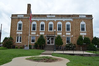
Charlotte is a town in Dickson County, Tennessee, United States. The population was 1,656 at the 2020 census. It is the county seat of Dickson County. This town is part of the Nashville metropolitan area.

<span class="mw-page-title-main">Dickson, Tennessee</span> City in Tennessee, United States

Dickson is a city in the U.S. state of Tennessee. Located in Dickson County. It is part of the Nashville metropolitan area. As of the 2020 census, Dickson's population was 16,058.

<span class="mw-page-title-main">Vanleer, Tennessee</span> Town in Tennessee, United States

Vanleer is a town in Dickson County, Tennessee, United States. The population was estimated to be 422 in 2019, up from 395 at the 2010 census. The town is approximately 49 miles northwest of Nashville and is located within the city's greater metropolitan area.

<span class="mw-page-title-main">White Bluff, Tennessee</span> Town in Tennessee, United States

White Bluff is a town in Dickson County, Tennessee, United States. The population was 3,862 at the 2020 census and 3,206 at the 2010 census. The community name derives from the White Bluff Iron Forge.

<span class="mw-page-title-main">Somerville, Tennessee</span> Town in Tennessee, United States

Somerville is a town in Fayette County, Tennessee, United States. It is part of the Memphis metropolitan area. The population was 3,415 at the 2020 census, up from 3,094 at the 2010 census. It is the county seat of Fayette County.

<span class="mw-page-title-main">Sunbright, Tennessee</span> City in Tennessee, United States

Sunbright is a city in Morgan County, Tennessee, United States. The population was 519 at the 2020 census.

<span class="mw-page-title-main">Monterey, Tennessee</span> Town in Tennessee, United States

Monterey is a town in Putnam County, Tennessee, United States. The population was 2,850 at the 2010 census. It is part of the Cookeville, Tennessee Micropolitan Statistical Area.

<span class="mw-page-title-main">Graysville, Tennessee</span> Town in Tennessee, United States

Graysville is a town in Rhea County, Tennessee, United States. The population was 1,471 at the 2020 census and 1,502 at the 2010 census.

<span class="mw-page-title-main">Carthage, Tennessee</span> Town in Tennessee, United States

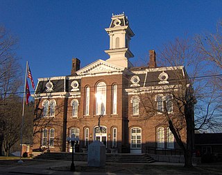
Carthage is a town in and the county seat of Smith County, Tennessee, United States; it is part of the Nashville Metropolitan Statistical Area. The population was 2,306 at the 2010 census. It is located on the Cumberland River, which was important to its early development. It is likely best known as the hometown of former Vice President and Senator Al Gore of the Democratic Party and his father, Senator Albert Gore, Sr. The younger Gore announced his 1988 and 2000 presidential bids, as well as his 1992 vice-presidential bid, from the steps of the Smith County Courthouse.

<span class="mw-page-title-main">Cumberland City, Tennessee</span> Town in Tennessee, United States

Cumberland City is a town in Stewart County, Tennessee. The population was 311 at the 2010 census. It is part of the Clarksville, TN — Kentucky Metropolitan Statistical Area.

<span class="mw-page-title-main">Dover, Tennessee</span> City in Tennessee, United States

Dover is a city in and the county seat of Stewart County, Tennessee, 67 miles (108 km) west-northwest of Nashville on the Cumberland River. Fort Donelson National Cemetery is in Dover. The population was 1,442 at the 2000 census and the 2010 census showed a population of 1,417.

<span class="mw-page-title-main">Ewing, Virginia</span> Census-designated place in Virginia, United States

Ewing is an unincorporated community and census-designated place (CDP) in Lee County, Virginia. The population was 439 at the 2010 U.S. Census. Ewing is one of the westernmost settlements in the Commonwealth of Virginia, before reaching the Cumberland Gap and the borders with Kentucky and Tennessee.

References

  1. "ArcGIS REST Services Directory". United States Census Bureau. Retrieved October 15, 2022.
  2. 1 2 U.S. Geological Survey Geographic Names Information System: Slayden, Tennessee
  3. 1 2 "Census Population API". United States Census Bureau. Retrieved October 15, 2022.
  4. 1 2 "U.S. Census website". United States Census Bureau . Retrieved January 31, 2008.
  5. 1 2 "Geographic Identifiers: 2010 Demographic Profile Data (G001): Slayden town, Tennessee". American Factfinder. U.S. Census Bureau. Archived from the original on February 13, 2020. Retrieved January 6, 2016.
  6. "US Gazetteer files: 2010, 2000, and 1990". United States Census Bureau. February 12, 2011. Retrieved April 23, 2011.
  7. "Census of Population and Housing: Decennial Censuses". United States Census Bureau . Retrieved March 4, 2012.
  8. "Incorporated Places and Minor Civil Divisions Datasets: Subcounty Resident Population Estimates: April 1, 2010 to July 1, 2012". Population Estimates. U.S. Census Bureau. Archived from the original on June 11, 2013. Retrieved December 11, 2013.