South Carthage, Tennessee

Last updated

South Carthage, Tennessee
South-Carthage-70N-old53-tn.jpg
Buildings along Old Highway 53
Smith County Tennessee Incorporated and Unincorporated areas South Carthage Highlighted 4769680.svg
Location of South Carthage in Smith County, Tennessee.
Coordinates: 36°14′44″N85°57′29″W / 36.24556°N 85.95806°W / 36.24556; -85.95806
Country United States
State Tennessee
County Smith
Area
[1]
  Total2.64 sq mi (6.84 km2)
  Land2.56 sq mi (6.64 km2)
  Water0.08 sq mi (0.20 km2)
Elevation
509 ft (155 m)
Population
 (2020) [2]
  Total1,490
  Density581.35/sq mi (224.45/km2)
Time zone UTC-6 (Central (CST))
  Summer (DST) UTC-5 (CDT)
FIPS code 47-69680 [3]
GNIS feature ID1270836 [4]

South Carthage is a town in Smith County, Tennessee, United States. The population was 1,322 at the 2010 census. [5] The town is located along the Cumberland River opposite Carthage.

Contents

Geography

South Carthage is located at 36°14′44″N85°57′29″W / 36.24556°N 85.95806°W / 36.24556; -85.95806 (36.245584, -85.958043). [6] The town stretches along the south bank of the Cumberland River from Goodall Island eastward to the river's confluence with the Caney Fork (river miles 306-309). South Carthage is traversed by U.S. Route 70N, and the highway's key intersection with State Route 25 and State Route 53 is located within the town's southeastern limits. The town is connected to Carthage via two bridges: the Cordell Hull Bridge on the west, and Veterans Memorial Bridge (which carries SR 25) on the east.

According to the United States Census Bureau, the town has a total area of 2.7 square miles (7.0 km2), of which 2.6 square miles (6.8 km2) is land and 0.077 square miles (0.2 km2), or 2.91%, is water. [5]

Demographics

Historical population
CensusPop.Note
1970 859
1980 1,00416.9%
1990 851−15.2%
2000 1,30253.0%
2010 1,3221.5%
2020 1,49012.7%
Sources: [7] [8] [2]

2020 census

South Carthage racial composition [9]
RaceNumberPercentage
White (non-Hispanic)1,32488.86%
Black or African American (non-Hispanic)483.22%
Native American 30.2%
Asian 140.94%
Other/Mixed 523.49%
Hispanic or Latino 493.29%

As of the 2020 United States census, there were 1,490 people, 536 households, and 344 families residing in the town.

2000 census

As of the census [3] of 2000, there were 1,302 people, 554 households, and 366 families residing in the town. The population density was 501.0 inhabitants per square mile (193.4/km2). There were 589 housing units at an average density of 226.6 per square mile (87.5/km2). The racial makeup of the town was 95.31% White, 2.46% African American, 0.08% Native American, 0.23% Asian, 0.54% from other races, and 1.38% from two or more races. Hispanic or Latino of any race were 1.38% of the population.

There were 554 households, out of which 33.0% had children under the age of 18 living with them, 50.2% were married couples living together, 12.8% had a female householder with no husband present, and 33.9% were non-families. 30.9% of all households were made up of individuals, and 16.6% had someone living alone who was 65 years of age or older. The average household size was 2.35 and the average family size was 2.92.

In the town, the population was spread out, with 25.4% under the age of 18, 7.1% from 18 to 24, 29.7% from 25 to 44, 21.4% from 45 to 64, and 16.4% who were 65 years of age or older. The median age was 37 years. For every 100 females, there were 86.0 males. For every 100 females age 18 and over, there were 79.8 males.

The median income for a household in the town was $30,592, and the median income for a family was $35,066. Males had a median income of $31,080 versus $20,577 for females. The per capita income for the town was $14,425. About 10.7% of families and 15.2% of the population were below the poverty line, including 14.6% of those under age 18 and 24.6% of those age 65 or over.

Related Research Articles

<span class="mw-page-title-main">Smith County, Tennessee</span> County in Tennessee, United States

Smith County is a county in the U.S. state of Tennessee. As of the 2020 census, the population was 19,904. Smith County is located in the region of the state known as Middle Tennessee. Its county seat is Carthage. The county was organized in 1799 and is named for Daniel Smith, a Revolutionary War veteran who made the first map of Tennessee and served as a United States senator.

<span class="mw-page-title-main">Fort Oglethorpe, Georgia</span> City in Georgia, United States

Fort Oglethorpe is a city predominantly in Catoosa County with some portions in Walker County in the U.S. state of Georgia. As of the 2020 census, the city had a population of 10,423. It is part of the Chattanooga, TN–GA Metropolitan Statistical Area. It is home to Lakeview – Fort Oglethorpe High School.

<span class="mw-page-title-main">Carthage, Maine</span> Town in the state of Maine, United States

Carthage is a town in Franklin County, Maine, United States. The population was 509 at the 2020 census.

<span class="mw-page-title-main">Jasper, Missouri</span> City in Missouri, United States

Jasper is a city in Jasper County, Missouri, United States. The population within the city limits was 931 at the 2010 census. It is part of the Joplin, Missouri Metropolitan Statistical Area.

West Carthage is a village in Jefferson County, New York, United States. The population was 1,780 at the 2020 census.

<span class="mw-page-title-main">Todd Township, Fulton County, Pennsylvania</span> Township in Pennsylvania, United States

Todd Township is a township in Fulton County, Pennsylvania, United States. The population was 1,616 at the 2020 census.

<span class="mw-page-title-main">Washington Township, Schuylkill County, Pennsylvania</span> Township in Pennsylvania, United States

Washington Township is a township that is located in Schuylkill County, Pennsylvania, United States. The population was 3,134 at the time of the 2020 census.

<span class="mw-page-title-main">Paradise Township, York County, Pennsylvania</span> Township in Pennsylvania, United States

Paradise Township is a settlement in York County, Pennsylvania, United States. As of the 2020 census, the township population was 3,966.

<span class="mw-page-title-main">Penn Township, York County, Pennsylvania</span> Township in Pennsylvania, United States

Penn Township is a township in York County, Pennsylvania, United States. The population was 17,494 at the 2020 census.

<span class="mw-page-title-main">Carthage, South Dakota</span> City in South Dakota, United States

Carthage is a city in Miner County, South Dakota, United States. The population was 127 at the 2020 census.

<span class="mw-page-title-main">Caryville, Tennessee</span> Town in Tennessee, United States

Caryville is a town in Campbell County, Tennessee, United States. The population was 2,297 at the 2010 census.

<span class="mw-page-title-main">Celina, Tennessee</span> City in Tennessee, United States

Celina is a city in and the county seat of Clay County, Tennessee, United States. The population was 1,495 at the 2010 census.

<span class="mw-page-title-main">Hornbeak, Tennessee</span> Town in Tennessee, United States

Hornbeak is a town in Obion County, Tennessee, United States. The population was 424 as of the 2010 census. It is part of the Union City, TN–KY Micropolitan Statistical Area.

<span class="mw-page-title-main">Livingston, Tennessee</span> Town in Tennessee, United States

Livingston is a town in Overton County, Tennessee, United States, and serves as the county seat. The population was 3,905 at the 2020 census and 4,058 at the 2010 census. The current mayor, Curtis Hayes, began serving his mayoral position in September 2006.

<span class="mw-page-title-main">Byrdstown, Tennessee</span> Town in Tennessee, United States

Byrdstown is a town in Pickett County, Tennessee, United States. The population was 798 at the 2020 census. It is the county seat of Pickett County.

<span class="mw-page-title-main">Oneida, Tennessee</span> Town in Tennessee, United States

Oneida is a town in Scott County, Tennessee, United States. The population was 3,787 at the 2020 census.

<span class="mw-page-title-main">Carthage, Tennessee</span> Town in Tennessee, United States

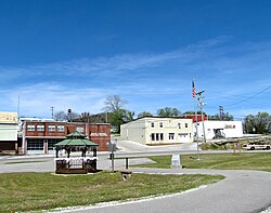
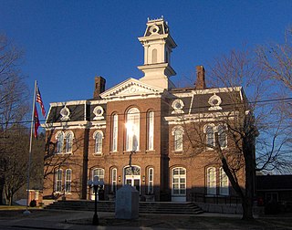
Carthage is a town in and the county seat of Smith County, Tennessee, United States; it is part of the Nashville Metropolitan Statistical Area. The population was 2,306 at the 2010 census. It is located on the Cumberland River, which was important to its early development. It is likely best known as the hometown of former Vice President and Senator Al Gore of the Democratic Party and his father, Senator Albert Gore, Sr. The younger Gore announced his 1988 and 2000 presidential bids, as well as his 1992 vice-presidential bid, from the steps of the Smith County Courthouse.

<span class="mw-page-title-main">Gordonsville, Tennessee</span> Town in Tennessee, United States

Gordonsville is a town in Smith County, Tennessee, United States. The population was 1,213 at the 2010 census.

<span class="mw-page-title-main">Cumberland City, Tennessee</span> Town in Tennessee, United States

Cumberland City is a town in Stewart County, Tennessee. The population was 311 at the 2010 census. It is part of the Clarksville, TN — Kentucky Metropolitan Statistical Area.

<span class="mw-page-title-main">Leon, West Virginia</span> Town in West Virginia, United States

Leon is a town in Mason County, West Virginia, United States, situated along the Kanawha River. The population was 137 at the 2020 census. It is part of the Point Pleasant, WV–OH Micropolitan Statistical Area.

References

  1. "ArcGIS REST Services Directory". United States Census Bureau. Retrieved October 15, 2022.
  2. 1 2 "Census Population API". United States Census Bureau. Retrieved October 15, 2022.
  3. 1 2 "U.S. Census website". United States Census Bureau . Retrieved January 31, 2008.
  4. "US Board on Geographic Names". United States Geological Survey. October 25, 2007. Retrieved January 31, 2008.
  5. 1 2 "Geographic Identifiers: 2010 Demographic Profile Data (DP-1): South Carthage town, Tennessee". U.S. Census Bureau, American Factfinder. Archived from the original on February 10, 2020. Retrieved March 25, 2013.
  6. "US Gazetteer files: 2010, 2000, and 1990". United States Census Bureau. February 12, 2011. Retrieved April 23, 2011.
  7. "Census of Population and Housing: Decennial Censuses". United States Census Bureau . Retrieved March 4, 2012.
  8. "Incorporated Places and Minor Civil Divisions Datasets: Subcounty Resident Population Estimates: April 1, 2010 to July 1, 2012". Population Estimates. U.S. Census Bureau. Archived from the original on June 11, 2013. Retrieved December 11, 2013.
  9. "Explore Census Data". data.census.gov. Retrieved December 27, 2021.