Related Research Articles

Bedford County is a county located in the U.S. state of Tennessee. As of the 2020 census, the population was 50,237. Its county seat is Shelbyville. Bedford County comprises the Shelbyville, TN Micropolitan Statistical Area, which is also included in the Nashville-Davidson-Murfreesboro, TN Combined Statistical Area.

Manchester is a city in Coffee County, Tennessee, United States. The population was 12,213 at the 2020 census. It is the county seat of Coffee County. The city is located halfway between Nashville and Chattanooga on Interstate 24.
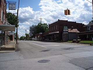
Chapel Hill is a town in northeastern Marshall County, Tennessee, United States. The town was named after Chapel Hill, North Carolina, by settlers from that area. The population was 1,717 as of the 2020 census.
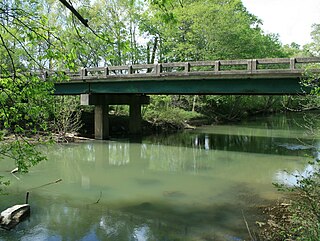
The Little Harpeth River is a 16.3-mile-long (26.2 km) tributary of the Harpeth River in Tennessee, just south of Nashville. Via the Harpeth, Cumberland, and Ohio rivers, it is part of the Mississippi River watershed.

The Battle of Talladega was fought between the Tennessee Militia and the Red Stick Creek Indians during the Creek War, in the vicinity of the present-day county and city of Talladega, Alabama, in the United States.
North and South Chickamauga Creek are short tributaries of the Tennessee River which join it near Chattanooga, Tennessee on the north and the south. West Chickamauga Creek is a much longer tributary of South Chickamauga Creek.
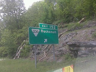
Bucksnort is a spring in Hickman County, Tennessee, United States, located on Sugar Creek, 0.2 miles (0.32 km) downstream of the confluence of the South Fork of Sugar Creek, 0.2 miles (0.32 km) to the south-east of Exit 152 on Interstate 40, and 2.7 miles (4.3 km) west of Spot. There are no U.S. Census statistics for the location and there is no post office. A trout farm business operated just upstream and adjacent to the I-40 in 1967, operated by Mr. and Mrs. Joda Austin.
Ten Mile is an unincorporated community in northern Meigs and southeastern Roane counties in the U.S. state of Tennessee.
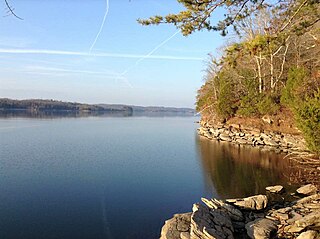
Watts Bar Lake is a reservoir on the Tennessee River created by Watts Bar Dam as part of the Tennessee Valley Authority system.
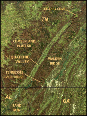
Sequatchie Valley is a relatively long and narrow valley in the U.S. state of Tennessee and, in some definitions, Alabama. It is generally considered to be part of the Cumberland Plateau region of the Appalachian Mountains; it was probably formed by erosion of a compression anticline, rather than rifting process as had been formerly theorized.
Flat Creek is an unincorporated community in Bedford County, in the U.S. state of Tennessee. Flat Creek was also a historic town in Williamson County, Tennessee.
Campbell Station is an unincorporated community in Maury County, in the U.S. state of Tennessee.

Overhill Cherokee was the term for the Cherokee people located in their historic settlements in what is now the U.S. state of Tennessee in the Southeastern United States, on the western side of the Appalachian Mountains. This name was used by 18th-century European traders and explorers from British colonies along the Atlantic coast, as they had to cross the mountains to reach these settlements.

Indian River is a 59.1-mile-long (95.1 km) tributary of the Manistique River on the Upper Peninsula of Michigan in the United States. It rises out of Hovey Lake at 46°17′36″N86°42′20″W on Hiawatha National Forest land in Alger County and flows south and east through a lake district and on through Schoolcraft County. The river flows into the 8,659 acre (35 km2) Indian Lake at 46°17′36″N86°42′20″W and flows out at 45°59′30″N86°17′15″W. It then flows east and south about 2.5 miles where it merges with the Manistique River, which then flows through Manistique and into Lake Michigan at 45°56′56″N86°14′45″W.

David Crockett State Park is a state park in Lawrenceburg, Tennessee.
Louse Creek is a stream in Lincoln County, Tennessee, in the United States.
Overall is an unincorporated community in Rutherford County, Tennessee.
Cripple Creek is a stream in the U.S. state of Tennessee. It is a tributary of East Fork Stones River.
Silver Creek is an unincorporated community in Marshall and Maury counties, in the U.S. state of Tennessee. A variant name was "Silvercreek".
Rich Creek is an unincorporated community in Marshall County, in the U.S. state of Tennessee. A variant name was "Richcreek".
References
- ↑ U.S. Geological Survey Geographic Names Information System: Overall Creek
- ↑ History of Tennessee from the Earliest Time to the Present. Goodspeed Publishing Company. 1886. p. 811.
35°55′24″N86°27′15″W / 35.92328°N 86.45425°W