List of rivers of South Carolina

Last updated

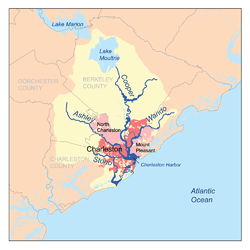
This is a list of rivers in the U.S. state of South Carolina :

Contents

By drainage basin

This list is arranged by drainage basin, from north to south, with respective tributaries indented under each larger stream's name. All rivers in South Carolina drain to the Atlantic Ocean.

Yadkin-Pee Dee drainage basin Peedeerivermap.png
Yadkin–Pee Dee drainage basin
Santee drainage basin Santeerivermap.png
Santee drainage basin
Rivers flowing to Charleston Harbor Charlestonriversmap.png
Rivers flowing to Charleston Harbor
Edisto drainage basin Edistorivermap.png
Edisto drainage basin
Savannah drainage basin Savannahrivermap.png
Savannah drainage basin

Alphabetically

See also

Related Research Articles

<span class="mw-page-title-main">Orangeburg County, South Carolina</span> County in South Carolina, United States

Orangeburg County is a county located in the U.S. state of South Carolina. As of the 2020 census, the population was 84,223. Its county seat is Orangeburg. The county was created in 1769.

Scouting in South Carolina has a long history, from the 1910s to the present day, serving thousands of youth in programs that suit the environment in which they live.

<span class="mw-page-title-main">Santee River</span> River in South Carolina, United States

The Santee River is a river in South Carolina in the United States, and is 143 miles (230 km) long. The Santee and its tributaries provide the principal drainage for the coastal areas of southeastern South Carolina and navigation for the central coastal plain of South Carolina, emptying into the Atlantic Ocean about halfway between Myrtle Beach and Charleston near the community of McClellanville. The farthest headwaters are 440 miles (708 km) away on the Catawba River in North Carolina. Besides the Catawba, other principal rivers of the Santee watershed include the Congaree, Broad, Linville, Saluda and the Wateree. The watershed drains a large portion of the Piedmont regions of South and North Carolina. The Santee River is the second largest river on the eastern coast of the United States, second only to the Susquehanna River in drainage area and flow. Much of the upper river is impounded by the expansive, horn-shaped Lake Marion reservoir, formed by the 8-mile (13 km)-long Santee Dam. The dam was built during the Great Depression of the 1930s as a Works Progress Administration (WPA) project to provide a major source of hydroelectric power for the state of South Carolina.

<span class="mw-page-title-main">Blackwater river</span> Slow-moving, dark-colored river flowing through forested swamps or wetlands

A blackwater river is a type of river with a slow-moving channel flowing through forested swamps or wetlands. Most major blackwater rivers are in the Amazon Basin and the Southern United States. The term is used in fluvial studies, geology, geography, ecology, and biology. Not all dark rivers are blackwater in that technical sense. Some rivers in temperate regions, which drain or flow through areas of dark black loam, are simply black due to the color of the soil; these rivers are black mud rivers. There are also black mud estuaries.

The Oolenoy River is a minor tributary of the Saluda River sourced near Sassafras Mountain in northern Pickens County, South Carolina. Approximately 37 miles in length, it empties into the South Fork Saluda River near Pumpkintown. It is part of the Santee River System.

<span class="mw-page-title-main">Congaree River</span> River in South Carolina, United States

The Congaree River is a short but wide river in South Carolina in the United States; It flows for approximately 53 miles (85 km). The river serves an important role as the final outlet channel for the entire Lower Saluda and Lower Broad watersheds, before merging with the Wateree River just north of Lake Marion to form the Santee River.

<span class="mw-page-title-main">Broad River (Carolinas)</span> River in North and South Carolina, United States

The Broad River is a principal tributary of the Congaree River, about 150 miles (240 km) long, in western North Carolina and northern South Carolina in the United States. Via the Congaree, it is part of the watershed of the Santee River, which flows to the Atlantic Ocean.

<span class="mw-page-title-main">Saluda River</span> River in South Carolina, USA

The Saluda River is a principal tributary of the Congaree River, about 200 mi (320 km) long, in northern and western South Carolina in the United States. Via the Congaree River, it is part of the watershed of the Santee River, which flows to the Atlantic Ocean.

The Bush River is a tributary of the Saluda River, 30 mi (48 km) long, in the Piedmont region of western South Carolina in the United States. Via the Saluda and Congaree Rivers, it is part of the watershed of the Santee River, which flows to the Atlantic Ocean.

The Pacolet River is a tributary of the Broad River, about 50 miles (80 km) long, in northwestern South Carolina in the United States. One of its principal headwaters tributaries also drains a small portion of western North Carolina. Via the Broad and Congaree rivers, it is part of the watershed of the Santee River, which flows to the Atlantic Ocean. The stream's name has also been spelled historically as "Pacolate River".

The Enoree River is a tributary of the Broad River, 85 mi (137 km) long, in northwestern South Carolina in the United States. Via the Broad and Congaree Rivers, it is part of the watershed of the Santee River, which flows to the Atlantic Ocean.

The Sandy River and its tributary the Little Sandy River are short rivers in north-central South Carolina in the United States. The Sandy is a tributary of the Broad River; via the Broad and Congaree Rivers, it is part of the watershed of the Santee River, which flows to the Atlantic Ocean.

<span class="mw-page-title-main">Sumter National Forest</span>

The Sumter National Forest is one of two forests in South Carolina that are managed together by the United States Forest Service, the other being the Francis Marion National Forest. The Sumter National Forest consists of 370,442 acres (1,499.13 km2) which are divided into 3 distinct sections in western and central South Carolina. The Enoree Ranger District is the largest, comprising roughly 170,000 acres in Chester, Fairfield, Laurens, Newberry, and Union counties. Next is the Long Cane Ranger District, comprising about 120,000 acres in Abbeville, Edgefield, Greenwood, McCormick, and Saluda counties. The smallest district is the Andrew Pickens Ranger District comprising over 85,000 acres which lies entirely in Oconee county and is part of the Appalachian Mountains. Forest headquarters of both South Carolina forests are located together in the state's capital city of Columbia.

<span class="mw-page-title-main">U.S. Route 17 in South Carolina</span> Segment of American highway

U.S. Highway 17 (US 17) is a 221.454-mile (356.396 km) north–south United States Numbered Highway in the U.S. state of South Carolina located near the Atlantic Ocean. The highway enters the state from Georgia at the Savannah River and serves Hardeeville, Charleston, Georgetown, and Myrtle Beach, before entering North Carolina near Calabash.

<span class="mw-page-title-main">Tyger River</span> River in South Carolina, United States

The Tyger River is a stream in the U.S. state of South Carolina, and a tributary of the Broad River. It is part of the Santee River Basin. It is a generally shallow and narrow river. Pollution in the north fork was the source of dispute in Friends of the Earth, Inc. v. Laidlaw Environmental Services, Inc.

References