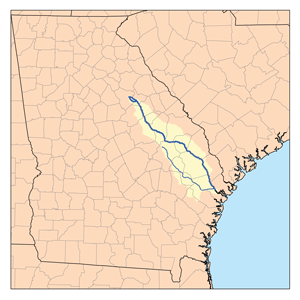
The Tugaloo River is a 45.9-mile-long (73.9 km) river bordering the U.S. states of Georgia and South Carolina. It was named for the Cherokee town of Tugaloo at the mouth of Toccoa Creek, near present-day Toccoa, Georgia and Travelers Rest in Stephens County, Georgia. It is fed by the Tallulah River and the Chattooga River, which each form an arm of Lake Tugalo, on the edge of Georgia's Tallulah Gorge State Park. The Tugaloo then flows out of the lake via Tugaloo Dam, passing into Lake Yonah and through Yonah Dam. The river then ends as an arm of Lake Hartwell, as does South Carolina's Seneca River. After flowing out of Lake Hartwell, it is called the Savannah River.
The South Branch Rancocas Creek is a 21.7-mile-long (34.9 km) tributary of Rancocas Creek in Burlington County, New Jersey in the United States. The South Branch Rancocas Creek drains an area of 144 square miles. Much of the upland agriculture within the Rancocas Creek basin lies inside the South Branch Rancocas Creek basin. It is also among the least developed parts of the Rancocas Creek watershed.
The Canoochee River is a 108-mile-long (174 km) river in southeastern Georgia in the United States. It is a tributary of the Ogeechee River, which flows to the Atlantic Ocean. In 1738 the Trustees of the colony mentioned the proposed house and ferry boat over the 'Cooanoochi River'.

The Frankstown Branch Juniata River is a 46.0-mile-long (74.0 km) tributary of the Juniata River in Blair and Huntingdon Counties, Pennsylvania, in the United States.
The Soque River and its watershed are located entirely within the county boundaries of Habersham County in northeast Georgia. The Soque is a tributary of the Chattahoochee River. Portions of the river run along State Route 197.
Sand Creek is a 43.3-mile-long (69.7 km) tributary of the St. Croix River in Pine County, eastern Minnesota, United States.
The Hudson River is a 49.5-mile-long (79.7 km) tributary of the Broad River in the U.S. state of Georgia. Via the Broad River, it is part of the Savannah River watershed.
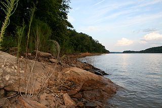
The Little River is a 72-mile-long (116 km) tributary of the Savannah River in the U.S. state of Georgia. It is formed by the juncture of its North and South forks 5 miles (8 km) north of Crawfordville, and it flows generally east to Clark Hill Lake, where it joins the Savannah River 2 miles (3 km) north of the dam.
Rocky Comfort Creek is a 62.4-mile-long (100.4 km) tributary of the Ogeechee River in the U.S. state of Georgia. Rising in Warren County 9 miles (14 km) northwest of Warrenton, it flows southeast, entering Glascock County and passing the town of Gibson, then continuing south into Jefferson County, where it reaches the Ogeechee River at Louisville.
Suwannoochee Creek is a 49.0-mile-long (78.9 km) tributary of the Suwannee River in the U.S. state of Georgia. It rises in western Clinch County, Georgia, about 11 miles (18 km) west of Homerville, and flows southeast to join the Suwannee near Fargo. For the lower half of its course it forms the boundary between Clinch and Echols counties.

The Beaverdam Creek Archaeological Site,, is an archaeological site located on a floodplain of Beaverdam Creek in Elbert County, Georgia approximately 0.8 km from the creek's confluence with the Savannah River, and is currently inundated by the Richard B. Russell Lake. The site consisted of a platform mound and an associated village site. Beaverdam Creek is thought to have been the center of a Mississippian culture simple chiefdom with a small resident population. The primary period of mound construction and village occupation dated to the regional Savannah period of the Middle Mississippian period, specifically 1200–1300 CE, with the site's abandonment occurring sometime after 1300. The mound was 1.5 metres (4.9 ft) high, and its base measured 25 metres (82 ft) by 25 metres (82 ft). The village boundaries were delineated as 15,000 square meters.
Beaverdam Creek is a tributary of the Wicomico River on the Eastern Shore of Maryland. Parker Pond and Schumaker Pond were created by damming Beaverdam Creek.
Beaverdam Creek is a stream in Hickman County, Tennessee, in the United States. It is a tributary of Duck River.
Beaverdam Creek is a stream in Georgia, and is a tributary of the Soque River. The creek is approximately 5.79 miles (9.32 km) long.
Cane Creek' is a stream in Georgia, and is a tributary of the Chestatee River. The creek is approximately 14.72 miles (23.69 km) long.
Beaverdam Creek is a stream in Audrain County in the U.S. state of Missouri. It is a tributary of the Salt River.
Hickory Stump Hollow is a valley in southeastern Ozark County in the Ozarks of southern Missouri. The valley headwaters lie just south of U.S. Route 160 east of Tecumseh. The stream enters Bridges Creek about one-quarter mile east of the waters of Norfork Lake.
Beaverdam Creek is a stream in Pettis County in the U.S. state of Missouri. It is a tributary of the South Fork Blackwater River.
Beaverdam Creek is a stream in Butler and Ripley counties in the Ozarks of southern Missouri. It is a tributary of the Little Black River.
Bills Creek is a stream in Ripley County in the Ozarks of southeast Missouri. It is a tributary of the Current River.


