Interstate 26 (I-26) is a main route of the Interstate Highway System in the Southeastern United States. Nominally east–west, as indicated by its even number, I-26 runs from the junction of U.S. Route 11W (US 11W) and US 23 in Kingsport, Tennessee, generally southeastward to US 17 in Charleston, South Carolina. The portion from Mars Hill, North Carolina, east to I-240 in Asheville, North Carolina, has signs indicating FUTURE I-26, because the highway does not yet meet all of the Interstate Highway standards. A short realignment, as an improvement in the freeway, was also planned in Asheville but has been postponed indefinitely due to North Carolina's budget shortfalls. Northward from Kingsport, US 23 continues to Portsmouth, Ohio, as Corridor B of the Appalachian Development Highway System, and beyond to Columbus, Ohio, as Corridor C. In conjunction with the Columbus–Toledo corridor in Ohio formed by I-75, US 23, and State Route 15 (SR 15), I-26 forms part of a mostly high-speed four-or-more-lane highway from the Great Lakes to the Atlantic Coast at Charleston, South Carolina. There are no official plans for extensions north of Kingsport, Tennessee.

Union County is a county located in the U.S. state of South Carolina. As of the 2010 census, the population was 28,961. Its county seat is Union. The county was created in 1785.

Whitmire is a town in Newberry County, South Carolina, United States, along the Enoree River. The population was 1,441 at the 2010 census. The town was named for George Fredrick Whitmire, who came from Stuttgart, Germany.
U.S. Route 176 is a spur of US 76 in the U.S. states of North Carolina and South Carolina. The U.S. Highway runs 237.98 miles (382.99 km) from US 25 Business and North Carolina Highway 225 in Hendersonville, North Carolina, east to US 52 in Goose Creek, South Carolina. US 176 serves the transition region between the Blue Ridge Mountains and Foothills of Western North Carolina and the Upstate, Midlands, and Lowcountry regions of South Carolina. The highway passes through and connects Spartanburg, one of two major cities in the Upstate, and Columbia, the South Carolina state capital and central city of the Midlands. US 176 parallels and serves as a secondary highway to Interstate 26 (I-26) except for between Spartanburg and Columbia, where the U.S. Highway deviates from the I-26 corridor to serve Union.

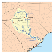
The Broad River is a principal tributary of the Congaree River, about 150 miles (240 km) long, in western North Carolina and northern South Carolina in the United States. Via the Congaree, it is part of the watershed of the Santee River, which flows to the Atlantic Ocean.

The Saluda River is a principal tributary of the Congaree River, about 200 mi (320 km) long, in northern and western South Carolina in the United States. Via the Congaree River, it is part of the watershed of the Santee River, which flows to the Atlantic Ocean.
The Pacolet River is a tributary of the Broad River, about 50 miles (80 km) long, in northwestern South Carolina in the United States. One of its principal headwaters tributaries also drains a small portion of western North Carolina. Via the Broad and Congaree rivers, it is part of the watershed of the Santee River, which flows to the Atlantic Ocean. The stream's name has also been spelled historically as "Pacolate River". There is a Pacolet River in Polk County in Florida.
The Enoree River is a tributary of the Broad River, 85 mi (137 km) long, in northwestern South Carolina in the United States. Via the Broad and Congaree Rivers, it is part of the watershed of the Santee River, which flows to the Atlantic Ocean.
The Sandy River and its tributary the Little Sandy River are short rivers in north-central South Carolina in the United States. The Sandy is a tributary of the Broad River; via the Broad and Congaree Rivers, it is part of the watershed of the Santee River, which flows to the Atlantic Ocean.

The Sumter National Forest is one of two forests in South Carolina that are managed together by the United States Forest Service, the other being the Francis Marion National Forest. The Sumter National Forest consists of 370,442 acres (1,499.13 km2) which are divided into 3 distinct sections in western and central South Carolina. The Enoree Ranger District is the largest, comprising roughly 170,000 acres in Chester, Fairfield, Laurens, Newberry, and Union counties. Next is the Long Cane Ranger District, comprising about 120,000 acres in Abbeville, Edgefield, Greenwood, McCormick, and Saluda counties. The smallest district is the Andrew Pickens Ranger District comprising over 85,000 acres which lies entirely in Oconee county and is part of the Appalachian Mountains. Forest headquarters of both South Carolina forests are located together in the state's capital city of Columbia.

Fort Prince was built in Spartanburg County, South Carolina for protection against the Cherokee Indians. It was near the residence of a Mr. Prince. Fort Prince was the general rallying point in times of danger when the people of the settlement sought safety. Just in front was a creek for their washing. Nearby stood a mill which ground corn, later known as Grays Mill. There was a Battle of Fort Prince during the American Revolutionary War, when Edward Hampton drove the British from the fort on July 15, 1780, and it stood for several years after.

South Carolina Highway 14 is a state highway in the U.S. state of South Carolina. The state highway runs 59.24 miles (95.34 km) from U.S. Route 76 Business in Laurens north to Interstate 26 (I-26) in Landrum. SC 14 connects Laurens and Landrum with Greer, the city between Greenville and Spartanburg where the highway crosses I-85 and US 29. The highway also parallels I-385 through Fountain Inn and Simpsonville, South Carolina in southeastern Greenville County. SC 14 is a part of the National Highway System between I-85 and US 29 in Greer.
South Carolina Highway 290 (SC 290) is a 30.582-mile (49.217 km) state highway in the northwestern part of the U.S. state of South Carolina. It courses through central Greenville and Spartanburg Counties.

South Carolina Highway 121 (SC 121) is a 134.200-mile (215.974 km) major state highway that travels north and south in central parts of the U.S. state of South Carolina. The highway is actually part of a long multi-state highway that also exists in Florida and Georgia, as Florida State Road 121 and Georgia State Route 121, respectively. Some see it as a de facto auxiliary route from U.S. Route 21 (US 21) in Rock Hill. Efforts to have the road upgraded to such status have failed however.
South Carolina Highway 357 (SC 357) is a 15.040-mile (24.205 km) state highway that travels from Greer to Campobello through some of the rural parts of western Spartanburg County, South Carolina.
South Carolina Highway 292 (SC 292) is a 13.640-mile-long (21.951 km) state highway in the U.S. state of South Carolina. The highway connects Duncan and the Inman area, via Lyman.
South Carolina Highway 395 (SC 395) is a 15.140-mile-long (24.365 km) state highway in the U.S. state of South Carolina. The highway connects the Lake Murray area with Newberry.
Whitney is an unincorporated area and census-designated place (CDP) adjacent to the city of Spartanburg in Spartanburg County, South Carolina, United States. It was first listed as a CDP prior to the 2020 census.