Stono River

Last updated
Charlestonriversmap.png
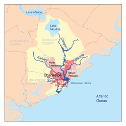
Map of the Charleston Harbor watershed showing Stono River
USA South Carolina relief location map.svg
Red pog.svg
Location of mouth
Location
Country United States
State South Carolina
Physical characteristics
Source 
  coordinates 32°42′36″N80°11′24″W / 32.7099007°N 80.1900971°W / 32.7099007; -80.1900971
Mouth  
  location
Atlantic Ocean
  coordinates
32°38′13″N80°00′54″W / 32.6368472°N 80.0150926°W / 32.6368472; -80.0150926 Coordinates: 32°38′13″N80°00′54″W / 32.6368472°N 80.0150926°W / 32.6368472; -80.0150926

The Stono River or Creek is a tidal channel in southeast South Carolina, located southwest of Charleston. The channel runs southwest to northeast between the mainland and Wadmalaw Island and Johns Island, from north Edisto River between Johns (West) and James (East) Islands. The Intracoastal Waterway runs through southwest–northeast section of the channel. [1] [2]

Contents

The Stono River is noted for the Stono Rebellion which started on September 9, 1739. Started by slaves from West Africa, likely from the Kingdom of Kongo, it became the largest slave uprising in the British mainland colonies prior to the American Revolution.

On June 20, 1779, it was also the site of the Battle of Stono Ferry during the American Revolution.

On January 30, 1863, as part of the American Civil War, a Confederate force captured the Union steamer USS Isaac Smith in which 8 men died and a further 17 were wounded in crossfire.

Bridges

See also

Related Research Articles

Intracoastal Waterway Inland waterway along the east and southeast coasts of the United States

The Intracoastal Waterway (ICW) is a 3,000-mile (4,800 km) inland waterway along the Atlantic and Gulf of Mexico coasts of the United States, running from Boston, Massachusetts, southward along the Atlantic Seaboard and around the southern tip of Florida, then following the Gulf Coast to Brownsville, Texas. Some sections of the waterway consist of natural inlets, saltwater rivers, bays, and sounds, while others are artificial canals. It provides a navigable route along its length without many of the hazards of travel on the open sea.

Gulf Intracoastal Waterway Portion of the Intracoastal Waterway located along the Gulf Coast of the United States

The Gulf Intracoastal Waterway is the portion of the Intracoastal Waterway located along the Gulf Coast of the United States. It is a navigable inland waterway running approximately 1,050 mi (1,690 km) from Carrabelle, Florida, to Brownsville, Texas.

Swing bridge

A swing bridge is a movable bridge that has as its primary structural support a vertical locating pin and support ring, usually at or near to its center of gravity, about which the turning span can then pivot horizontally as shown in the animated illustration to the right. Small swing bridges as found over canals may be pivoted only at one end, opening as would a gate, but require substantial underground structure to support the pivot.

Sabine Lake Estuary on the Texas–Louisiana border

Sabine Lake is a bay on the Gulf coasts of Texas and Louisiana, located approximately 90 miles (140 km) east of Houston and 160 miles (260 km) west of Baton Rouge, adjoining the city of Port Arthur. The lake is formed by the confluence of the Neches and Sabine Rivers and connects to the Gulf of Mexico through Sabine Pass. It forms part of the Texas–Louisiana border, falling within Jefferson and Orange Counties in Texas and Cameron Parish, Louisiana.

State Road A1A (SR A1A) is a north–south Florida State Road that runs along the Atlantic Ocean, from Key West at the southern tip of Florida, to Fernandina Beach, just south of Georgia on Amelia Island. It is the main road through most oceanfront towns. Part of SR A1A is designated the A1A Scenic and Historic Coastal Byway, a National Scenic Byway. A portion of SR A1A that passes through Volusia County is designated the Ormond Scenic Loop and Trail, a Florida Scenic Highway. It is also called the Indian River Lagoon Scenic Highway from State Road 510 at Wabasso Beach to U.S. Route 1 in Cocoa. SR A1A is famous worldwide as a center of beach culture in the United States, a scenic coastal route through most Atlantic coastal cities and beach towns, including the unique tropical coral islands of the Florida Keys. SR A1A also serves as a major thoroughfare through Miami Beach and other south Florida coastal cities.

Mississippi Sound Wide body of water, connecting two larger bodies of water along Mississippi and Alabama, US

The Mississippi Sound is a sound along the Gulf Coast of the United States. It runs east-west along the southern coasts of Mississippi and Alabama, from Waveland, Mississippi, to the Dauphin Island Bridge, a distance of about 90 miles (145 km). The sound is separated from the Gulf on its southern side by the Mississippi–Alabama barrier islands: Cat, Ship, Horn, West Petit Bois, Petit Bois, and Dauphin. Ship, Horn, West Petit Bois and Petit Bois Islands are part of the National Park Service's Gulf Islands National Seashore. Those islands separate the sound from the Gulf of Mexico. The sediment of the islands was created partly by the ancient Mississippi River when the St. Bernard Lobe of the Mississippi Delta was active over two thousand years ago. The expansion of the St. Bernard subdelta slowly isolated the Mississippi Sound from ocean dynamics of the open Gulf of Mexico.

Halifax River River in Florida, United States

The Halifax River is part of the Atlantic Intracoastal Waterway, located in northeast Volusia County, Florida. The waterway was originally known as the North Mosquito River, but was renamed after George Montagu-Dunk, 2nd Earl of Halifax, during the British occupation of Florida (1763–1784).

Johns Island, South Carolina Island in South Carolina, United States

Johns Island is an island in Charleston County, South Carolina, United States, and is the largest island in the state of South Carolina. Johns Island is bordered by the Wadmalaw, Seabrook, Kiawah, Edisto, Folly, and James islands; the Stono and Kiawah rivers separate Johns Island from its border islands. It is the fourth-largest island on the US east coast, surpassed only by Long Island, Mount Desert Island and Martha's Vineyard. Johns Island is 84 square miles (220 km2) in area, with a population of 21,500 people.

Bogue Sound

Bogue Sound is a medium-sized geographic sound in the state of North Carolina. The sound is part of North Carolina's "Crystal Coast", a tourism marketing term that is also used interchangeably with the term "Southern Outer Banks."

Louisiana Highway 82

Louisiana Highway 82 (LA 82) is a state highway located in southern Louisiana. It runs 142.87 miles (229.93 km) in a general east–west direction from the Texas state line east of Port Arthur to the Vermilion–Lafayette parish line southwest of Youngsville.

Haulover Canal United States historic place

The Haulover Canal is a waterway north of Merritt Island, Florida, near the former site of Allenhurst, that connects Mosquito Lagoon with the Indian River, and is part of the Intracoastal Waterway.

Florida State Road 64

State Road 64 extends from City Road 789 near the Gulf of Mexico in Holmes Beach on Anna Maria Island in Manatee County to US 27/US 98 in Avon Park in Highlands County. State Road 64 travels from west to east through the counties of Manatee, Hardee and Highlands. It is a mostly rural two-lane highway going through only two cities, Bradenton and Zolfo Springs. It crosses the Gulf Intracoastal Waterway as well as the Braden River, Lake Manatee, and the Myakka River. East of Avon Park, a bi-county extension runs northeast into Polk County which runs through Lake Wales Ridge State Forest and terminates at the Avon Park US Air Force Base. It is designated as the Florida Cracker Trail from Bradenton to the Hardee County Line.

Brevard County, Florida has transportation available in the usual modes for a coastal county - highways, shipping, and airlines.

John F. Limehouse Memorial Bridge

The John F. Limehouse Memorial Bridge, located about 15 miles west of downtown Charleston, South Carolina, was completed in 2003. It replaced an obsolete low-level swing bridge over the Stono River. The new bridge, which crosses a channel between Johns Island and St. Andrews Parish, an area generally called West Ashley, was completed under a partnership between the South Carolina Department of Transportation (SCDOT) and the United States Coast Guard.

Laguna Madre (United States) Hypersaline lagoon in Texas, US

The Laguna Madre is a long, shallow, hypersaline lagoon along the western coast of the Gulf of Mexico in Nueces, Kenedy, Kleberg, Willacy and Cameron Counties in Texas, United States. It is one of seven major estuaries along the Gulf Coast of Texas. The roughly 20-mile (32 km) long Saltillo Flats land bridge divides it into Upper and Lower lagoons joined by the Intracoastal Waterway, which has been dredged through the lagoon. Cumulatively, Laguna Madre is approximately 130 miles (209 km) long, the length of Padre Island in the US. The main extensions include Baffin Bay in Upper Laguna Madre, Red Fish Bay just below the Saltillo Flats, and South Bay near the Mexican border. As a natural ecological unit, the Laguna Madre of the United States is the northern half of the ecosystem as a whole, which extends into Tamaulipas, Mexico ca. 144 miles (233 km.) south of the US border, to the vicinity of the Rio Soto La Marina and the town of La Pesca, extending ca.275 miles (442.57 km.) through USA and Mexico all total.

Matanzas Bay

Matanzas Bay is a saltwater bay in St. Johns County, Florida; the entrance to the bay from the South Atlantic is via St. Augustine inlet. Bodies of water that connect to the bay in addition to the South Atlantic are clockwise from the inlet:

South Carolina Highway 700 (SC 700) is a 20.380-mile (32.798 km) state highway in the U.S. state of South Carolina. Known for most of its length as Maybank Highway, the state highway travels from a dead end in Rockville east to U.S. Route 17 (US 17) in Charleston. SC 700 connects Charleston with James Island, Johns Island, and Wadmalaw Island in southwestern Charleston County.

References

  1. Columbia University Press. "Stono River" . Retrieved 2 November 2006.
  2. U.S. Geological Survey Geographic Names Information System: Stono River