
A swing bridge is a movable bridge that has as its primary structural support a vertical locating pin and support ring, usually at or near to its center of gravity, about which the turning span can then pivot horizontally as shown in the animated illustration to the right. Small swing bridges as found over canals may be pivoted only at one end, opening as would a gate, but require substantial underground structure to support the pivot.

The Bob Graham Sunshine Skyway Bridge, often referred to as the Sunshine Skyway Bridge or simply the Skyway, is a cable-stayed bridge spanning the Lower Tampa Bay connecting St. Petersburg, Florida to Terra Ceia. The current Sunshine Skyway opened in 1987 and is the second bridge of that name on the site. It was designed by the Figg & Muller Engineering Group and built by the American Bridge Company and is considered a symbol of Florida.
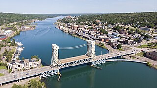
The Portage Lake Lift Bridge connects the cities of Hancock and Houghton, in the US state of Michigan. It crosses Portage Lake, a portion of the waterway which cuts across the Keweenaw Peninsula with a canal linking the final several miles to Lake Superior to the northwest. US Highway 41 (US 41) and M-26 are both routed across the bridge. It is the only land-based link between the north and south sections of the Keweenaw peninsula.

The Richmond–San Rafael Bridge is the northernmost of the east–west crossings of the San Francisco Bay in California, USA. Officially named after California State Senator John F. McCarthy, it bridges Interstate 580 from Richmond on the east to San Rafael on the west. It opened in 1956, replacing ferry service by the Richmond–San Rafael Ferry Company.

The Burlington Northern Railroad Bridge 5.1 or BNSF Railway Bridge 5.1, also known as the St. Johns Railroad Bridge or the Willamette River Railroad Bridge, is a through truss railway bridge with a vertical lift that spans the Willamette River in Portland, Oregon, United States. Built by the Spokane, Portland and Seattle Railway (SP&S) and completed in 1908, it was originally a swing-span bridge, and its swing-span section was the longest in the world at the time. However, 81 years later the main span was converted from a swing-type to a vertical-lift type, in order to widen the navigation channel. The lift span is one of the highest and longest in the world. The bridge consists of five sections, with the two sections closest to the bank on each side fixed.

The Seven Mile Bridge is a bridge in the Florida Keys, in Monroe County, Florida, United States. It connects Knight's Key in the Middle Keys to Little Duck Key in the Lower Keys. Among the longest bridges in existence when it was built, it is part of the Overseas Highway in the Keys, which is part of the 2,369-mile (3,813 km) U.S. Route 1.

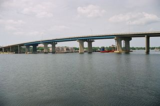
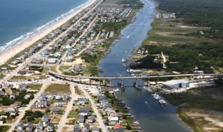
The Shands Bridge is a two-lane automobile bridge carrying SR 16 over the St. Johns River south of Jacksonville, Florida.

The Broadway Bridge is a vertical-lift bridge across the Harlem River Ship Canal in the borough of Manhattan in New York City. It connects the neighborhoods of Inwood on Manhattan Island and Marble Hill on the mainland. The bridge consists of two decks. The lower deck carries Broadway, which is designated as U.S. Route 9 at this location. The upper deck carries the New York City Subway's IRT Broadway–Seventh Avenue Line, serving the 1 train.

The Willis Avenue Bridge is a swing bridge that carries road traffic northbound over the Harlem River between the New York City boroughs of Manhattan and the Bronx, United States. It connects First Avenue in Manhattan with Willis Avenue in the Bronx. The New York City Department of Transportation is responsible for maintaining and operating the bridge.

The Arthur Ravenel Jr. Bridge is a cable-stayed bridge over the Cooper River in South Carolina, US, connecting downtown Charleston to Mount Pleasant. The bridge has a main span of 1,546 feet, the third longest among cable-stayed bridges in the Western Hemisphere. It was built using the design-build method and was designed by Parsons Brinckerhoff.

Johns Island is an island in Charleston County, South Carolina, United States, and is the largest island in the state of South Carolina. Johns Island is bordered by the Wadmalaw, Seabrook, Kiawah, Edisto, Folly, and James islands; the Stono and Kiawah rivers separate Johns Island from its border islands. It is the fourth-largest island on the US east coast, surpassed only by Long Island, Mount Desert Island and Martha's Vineyard. Johns Island is 84 square miles (220 km2) in area, with a population of 21,500 people.
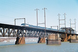
The Amtrak Susquehanna River Bridge is a Howe deck truss structure that carries two tracks of Amtrak's Northeast Corridor line across the Susquehanna River between Havre de Grace and Perryville, Maryland.
Rikers Island Bridge is a girder bridge that connects Rikers Island in the borough of the Bronx with the borough of Queens in New York City. The bridge begins in the Steinway neighborhood of Queens near the intersection of Hazen Street and 19th Avenue and continues to the south side of Rikers Island.

The Paul Gelegotis Bridge, also known as the Stono Bridge, is located in Charleston, South Carolina, United States; it connects James Island and Johns Island on SC 700. This bridge opened in late 2003, on the historically significant site of a series of former Stono Bridges.

The Black Rock Lock located in Buffalo, New York is 650 feet (200 m) in length and 70 feet (21 m) wide. There is only one chamber and the total weight of the gate is 480 tons. The lock has been a part of Black Rock since the state of New York built the Erie Canal in 1833.

The Van Buren Street Bridge is a swing span, steel motor vehicle bridge spanning the Willamette River at Corvallis in the U.S. state of Oregon. Opened in 1913, the black colored bridge was the first bridge across the river at Corvallis and is now the third oldest bridge across the river. Owned by the state and maintained by the Oregon Department of Transportation (ODOT), the 708-foot (216 m) long span is of a through truss design and carries one lane of traffic of Oregon Route 34 eastbound from Corvallis into neighboring Linn County. The bridge no longer is able to swing open.

Niantic River Bridge, also known as Amtrak Bascule Bridge No. 116.74, is a railroad bridge carrying Amtrak's Northeast Corridor line across the Niantic River between East Lyme and Waterford, Connecticut. It is a drawbridge with a bascule-type draw span. A new bridge was constructed in 2012 to replace the former span built in 1907. It opened on September 8, 2012. Related construction work finished in June 2013.
The Brooks Bridge is a four-lane steel and concrete structure that carries highway U.S. Route 98 (US 98) over Santa Rosa Sound just west of the Choctawhatchee Bay between downtown Fort Walton Beach, Florida and the 3-mile-long (4.8 km) section of Okaloosa Island controlled by the city of Fort Walton Beach. It is named for John Thomas Brooks, who, in 1868, purchased 111 acres of what is now downtown Fort Walton Beach. The area on the north side of the sound where the bridge connects was known as Brooks Landing. It has a charted clearance of 50 feet (15 m) above the water.
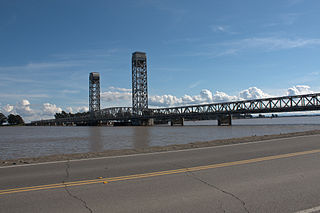
The Rio Vista Bridge is a continuous truss span with a vertical-lift bridge in the middle which carries California State Route 12 across the Sacramento River at Rio Vista, California. The present bridge was completed in 1960 and is one of several moveable bridges spanning rivers in the Sacramento–San Joaquin River Delta. It is named after Helen Madere, who served as vice-mayor of Rio Vista. As of 2013 the bridge carries approximately 21,000 cars per day.
The 65-foot-high (20 m) Holden Beach Bridge carries NC 130 across the Atlantic Intracoastal Waterway (ICW), connecting the town of Holden Beach to the mainland. The 1,800-foot-long (550 m) structure, built under contract to the North Carolina Department of Transportation, consists of 20 approach spans of Type III and IV prestressed concrete AASHTO girders and 3 channel spans of prestressed, precast box girders.

