West Columbia, South Carolina | |
|---|---|
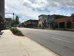 State Street in downtown West Columbia | |
 Seal | |
| Motto: "Bridging Past, Present, And Future" [1] | |
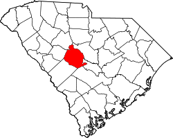
 Location in Lexington County, South Carolina | |
| Coordinates: 33°59′30″N81°07′23″W / 33.99167°N 81.12306°W [2] | |
| Country | United States |
| State | South Carolina |
| County | Lexington |
| Government | |
| • Type | City Council, City Administrator |
| • Mayor | Tem Miles [3] |
| Area | |
• Total | 9.47 sq mi (24.53 km2) |
| • Land | 9.30 sq mi (24.08 km2) |
| • Water | 0.17 sq mi (0.45 km2) |
| Elevation | 282 ft (86 m) |
| Population | |
• Total | 17,416 |
| • Density | 1,873.5/sq mi (723.38/km2) |
| Time zone | UTC−5 (EST) |
| • Summer (DST) | UTC−4 (EDT) |
| Area codes | 803, 839 |
| FIPS code | 45-75850 |
| GNIS feature ID | 2405706 [2] |
| Website | www |
West Columbia, formerly Brookland, is a city and commuter town in the suburban eastern sections of Lexington County, South Carolina, United States. According to the 2010 census, the population was 14,988, and the 2019 population estimate was 17,998. [6] West Columbia is bordered to the east by Columbia, the state capital, across the Congaree River. It is near Columbia's city center or downtown district as well as the South Carolina State House and the Congaree Vista, known locally as "the Vista". The city is bordered to the south by its sister suburb, Cayce. A small portion of the city borders the town of Lexington to the east. [7] [8] West Columbia is part of the greater Columbia, South Carolina metropolitan area.