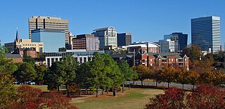
Columbia is the capital of the U.S. state of South Carolina. With a population of 136,632 as of the 2020 U.S. Census, it is the second-largest city in South Carolina. The city serves as the county seat of Richland County, and a portion of the city extends into neighboring Lexington County. It is the center of the Columbia metropolitan statistical area, which had a population of 829,470 and is the 72nd-largest metropolitan statistical area in the nation. The name Columbia is a poetic term used for the United States, derived from the name of Christopher Columbus, who explored for the Spanish Crown. Columbia is often abbreviated as Cola, leading to its nickname as "Soda City."

Saluda County is a county in the U.S. state of South Carolina. As of the 2020 census, the population was 18,862. Its county seat is Saluda. The county was formed from northern and eastern portions of Edgefield County.
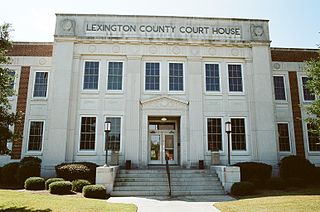
Lexington County is a county located in the U.S. state of South Carolina. As of the 2020 census, the population was 293,991, and the 2021 population estimate was 300,137. Its county seat and largest town is Lexington. The county was chartered in 1785 and was named in commemoration of Lexington, Massachusetts, the site of the Battle of Lexington in the American Revolutionary War. Lexington County is the sixth-largest county in South Carolina by population and is part of the Columbia, SC Metropolitan Statistical Area.

Greenwood County is a county located in the U.S. state of South Carolina. As of the 2020 census, its population was 69,351. Its county seat is Greenwood.

Pelzer is a town in Anderson County in South Carolina, United States, along the Saluda River. The population was 89 at the 2010 census.

Cayce is a city in the U.S. state of South Carolina, along the Congaree River. The population was 12,528 at the 2010 census and rose to 13,789 in the 2020 United States Census, and it is the third-most populated municipality in Lexington County. The city is primarily in Lexington County, with additional, predominantly rural land to the east in Richland County. Cayce is part of the Columbia Metropolitan Statistical Area and is within South Carolina's Midlands region.

Lexington is the largest town in and the county seat of Lexington County, South Carolina, United States. It is a suburb of the state capital, Columbia. The population was 23,568 at the 2020 Census, and it is the second-largest municipality in the greater Columbia area. The 2021 estimated population is 24,208. According to the Central Midlands Council of Governments, the greater Lexington area had an estimated population of 111,549 in 2020 and is considered the fastest-growing area in the Midlands. Lexington's town limits are bordered to the east by the city of West Columbia.

West Columbia, formerly Brookland, is a city and commuter town in the suburban eastern sections of Lexington County, South Carolina, United States. According to the 2010 census, the population was 14,988, and the 2019 population estimate was 17,998. West Columbia is bordered to the east by Columbia, the state capital, across the Congaree River. It is near Columbia's city center or downtown district as well as the South Carolina State House and the Congaree Vista, known locally as "the Vista." The city is bordered to the south by its sister suburb, Cayce. A small portion of the city borders the town of Lexington to the east. West Columbia is part of the greater Columbia, SC metropolitan statistical area.

Batesburg-Leesville is a town in Lexington and Saluda counties, South Carolina, United States. The town's population was 5,362 as of the 2010 census and an estimated 5,415 in 2019.

U.S. Route 176 is a spur of US 76 in the U.S. states of North Carolina and South Carolina. The U.S. Highway runs 237.98 miles (382.99 km) from US 25 Business and North Carolina Highway 225 in Hendersonville, North Carolina, east to US 52 in Goose Creek, South Carolina. US 176 serves the transition region between the Blue Ridge Mountains and Foothills of Western North Carolina and the Upstate, Midlands, and Lowcountry regions of South Carolina. The highway passes through and connects Spartanburg, one of two major cities in the Upstate, and Columbia, the South Carolina state capital and central city of the Midlands. US 176 parallels and serves as a secondary highway to Interstate 26 (I-26) except for between Spartanburg and Columbia, where the U.S. Highway deviates from the I-26 corridor to serve Union.

U.S. Route 378 (US 378) is a spur of US 78 in the U.S. states of Georgia and South Carolina. The U.S. Highway runs 234.30 miles (377.07 km) from US 78, Georgia State Route 10 (SR 10), SR 17, and SR 47 in Washington, Georgia, east to US 501 Business in Conway, South Carolina. US 378 connects the Central Savannah River Area in both states with the Midlands and Pee Dee regions of South Carolina. The U.S. Highway's western portion, which connects Washington and Lincolnton in Georgia and McCormick, Saluda, and Lexington in South Carolina, is mainly a rural highway. US 378 is a major suburban and urban highway through Lexington and South Carolina's state capital, Columbia. The highway has a lengthy concurrency with US 76 between Columbia and Sumter and serves as a major route between the Midlands and the Myrtle Beach area, between which the highway has a business route through Lake City.

U.S. Highway 178 is a spur of U.S. Highway 78. It currently runs for 240.49 miles (387.03 km) from Dorchester, South Carolina, at U.S. Highway 78 to Rosman, North Carolina, at U.S. Highway 64. It passes through the states of South Carolina and North Carolina. It goes through the cities of Pickens, Anderson, North, Orangeburg, Harleyville, South Carolina and Bowman, South Carolina.

The Congaree River is a short but wide river in South Carolina in the United States; It flows for approximately 53 miles (85 km). The river serves an important role as the final outlet channel for the entire Lower Saluda and Lower Broad watersheds, before merging with the Wateree River just north of Lake Marion to form the Santee River.
The Cherokee Path was the primary route of English and Scots traders from Charleston to Columbia, South Carolina in Colonial America. It was the way they reached Cherokee towns and territories along the upper Keowee River and its tributaries. In its lower section it was known as the Savannah River. They referred to these towns along the Keowee and Tugaloo rivers as the Lower Towns, in contrast to the Middle Towns in Western North Carolina and the Overhill Towns in present-day southeastern Tennessee west of the Appalachian Mountains.

Lake Murray is a reservoir in the U.S. state of South Carolina. It is approximately 50,000 acres in size, and has roughly 650 mi of shoreline. It was impounded in the late 1920s to provide hydroelectric power to the state of South Carolina. Lake Murray is fed by the Saluda River, which flows from upstate South Carolina near the North Carolina state line. The Saluda Dam was an engineering feat at the time of its construction. The dam, using the native red clay soil and bedrock, was the largest earthen dam in the world when it was completed in 1930. Lake Murray itself is named after the project's chief engineer, William S. Murray. The Saluda Dam is approximately 1.5 miles (2.4 km) long and 220 feet (67 m) high. Lake Murray is 41 miles (66 km) long, and 14 miles (23 km) wide at its widest point. At the time when the lake was finished, it was the world's largest man-made reservoir.

The Saluda River is a principal tributary of the Congaree River, about 200 mi (320 km) long, in northern and western South Carolina in the United States. Via the Congaree River, it is part of the watershed of the Santee River, which flows to the Atlantic Ocean.

Interstate 20 (I-20) is the main east–west Interstate in the state of South Carolina, linking the state with important transportation and business hubs to the north, west, and south, including Atlanta, Georgia; Charlotte, North Carolina ; Savannah, Georgia ; and Washington, D.C..

Interstate 26 (I-26) is a South Carolina Interstate highway running generally east–west from near Landrum, in Spartanburg County, to U.S. Route 17 (US 17), in Charleston, South Carolina. It is also the longest Interstate Highway in South Carolina.
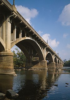
Gervais Street Bridge is a historic bridge in South Carolina in the United States and it is listed on the National Register of Historic Places. It is an arch bridge constructed from reinforced concrete. Construction began in 1926 and the bridge was completed in 1928. It was added to the National Register of Historic Places in 1980.
Granby was the first European settlement in the area of present-day Columbia in the U.S. state of South Carolina. Settlement began around 1718 with the establishment of a trading post by the British on the Congaree River. Many small farms were settled by German, Swiss, and Scots-Irish immigrants. Granby was the largest town and county seat of Lexington County until the early 19th century, when the town began to gradually decline as Columbia, the state capital, grew. The once thriving colonial town was mostly unoccupied after the first quarter of the 19th century. Today, the area is part of present-day Cayce.


