National Register of Historic Places listings in Hampton County, South Carolina

Last updated
Location of Hampton County in South Carolina Map of South Carolina highlighting Hampton County.svg
Location of Hampton County in South Carolina

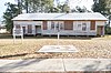
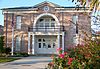
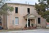
This is a list of the National Register of Historic Places listings in Hampton County, South Carolina.

Contents

This is intended to be a complete list of the properties on the National Register of Historic Places in Hampton County, South Carolina, United States. The locations of National Register properties for which the latitude and longitude coordinates are included below, may be seen in a map. [1]

National Register of Historic Places federal list of historic sites in the United States

The National Register of Historic Places (NRHP) is the United States federal government's official list of districts, sites, buildings, structures and objects deemed worthy of preservation for their historical significance. A property listed in the National Register, or located within a National Register Historic District, may qualify for tax incentives derived from the total value of expenses incurred in preserving the property.

Hampton County, South Carolina County in the United States

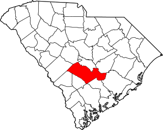
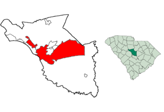
Hampton County is a rural county located in the U.S. state of South Carolina. As of the 2010 census, the population was 21,090. Its county seat is Hampton. It was named for Confederate Civil War general Wade Hampton, who in the late 1870s was elected as governor of South Carolina. The county includes two small urban clusters: Hampton and Estill (3,637).

South Carolina State of the United States of America

South Carolina is a state in the Southeastern United States and the easternmost of the Deep South. It is bordered to the north by North Carolina, to the southeast by the Atlantic Ocean, and to the southwest by Georgia across the Savannah River.

There are 15 properties listed on the National Register in the county.

This National Park Service list is complete through NPS recent listings posted June 28, 2019. [2]
Map all coordinates using: OpenStreetMap  
Download coordinates as: KML  ·  GPX

Current listings

[3] Name on the Register [4] ImageDate listed [5] Location City or townDescription
1 American Legion Hut
American Legion Hut Hampton American Legion Hut 6.JPG
American Legion Hut
October 27, 2000
(#00001235)
Junction of Hoover St. and Jackson Ave.
32°52′19″N81°07′03″W / 32.871944°N 81.1175°W / 32.871944; -81.1175 (American Legion Hut)
Hampton
2 Bank of Hampton
Bank of Hampton Hampton Bank Front.jpg
Bank of Hampton
May 30, 2001
(#01000606)
15 Elm St., E.
32°51′59″N81°06′31″W / 32.866389°N 81.108611°W / 32.866389; -81.108611 (Bank of Hampton)
Hampton
3 Cohasset
Cohasset Cohasset.jpg
Cohasset
July 24, 1986
(#86001935)
U.S. Route 601
32°55′58″N81°04′37″W / 32.93269°N 81.07694°W / 32.93269; -81.07694 (Cohasset)
Crocketville On provat property, gated
4 Gifford Rosenwald School
Gifford Rosenwald School 1-Front-view-Hampton-SC-GRS.jpg
Gifford Rosenwald School
October 4, 2017
(#100001720)
6146 Columbia Hwy.
32°51′50″N81°14′17″W / 32.863991°N 81.237936°W / 32.863991; -81.237936 (Gifford Rosenwald School)
Gifford
5 Gravel Hill Plantation May 10, 2010
(#10000240)
3954 Augusta Stage Coach Rd
32°58′00″N81°23′09″W / 32.96669°N 81.38593°W / 32.96669; -81.38593 (Gravel Hill Plantation)
Garnett
6 Hampton Colored School
Hampton Colored School Hampton Colored School 3.jpg
Hampton Colored School
February 28, 1991
(#91000233)
W. Holly St. east of its junction with Hoover St.
32°52′04″N81°07′15″W / 32.867778°N 81.120833°W / 32.867778; -81.120833 (Hampton Colored School)
Hampton
7 Hampton County Courthouse
Hampton County Courthouse Hampton County Courthouse 3.jpg
Hampton County Courthouse
December 12, 1978
(#78002517)
U.S. Route 278
32°51′58″N81°06′34″W / 32.86616°N 81.10932°W / 32.86616; -81.10932 (Hampton County Courthouse)
Hampton
8 Hampton County Jail
Hampton County Jail Hampton county Jail, Hampton, SC, US.jpg
Hampton County Jail
June 23, 2011
(#11000405)
702 1st St., W.
32°51′55″N81°06′40″W / 32.8653993°N 81.1112201°W / 32.8653993; -81.1112201 (Hampton County Jail)
Hampton Now the Hampton County Historical Society Museum
9 John Lawton House
John Lawton House John Lawton House, Estil, SC, US.jpg
John Lawton House
July 1, 2009
(#09000484)
118 3rd. St. on NRHP, now numbered 316
32°45′14″N81°14′22″W / 32.753878°N 81.239325°W / 32.753878; -81.239325 (John Lawton House)
Estill
10 Lawtonville Baptist Church
Lawtonville Baptist Church Lawtonville Baptist Church, Estill, SC, US.jpg
Lawtonville Baptist Church
October 9, 2012
(#12000848)
194 E. 4th St
32°45′18″N81°14′18″W / 32.7549°N 81.23826°W / 32.7549; -81.23826 (Lawtonville Baptist Church)
Estill
11 Oak Grove
Oak Grove Oak Grove, Hampton County, SC, US.jpg
Oak Grove
July 12, 1976
(#76001704)
Southwest of Brunson
32°54′49″N81°12′58″W / 32.91357°N 81.216°W / 32.91357; -81.216 (Oak Grove)
Brunson
12 Palmetto Theatre
Palmetto Theatre Palmetto Theatre, Hampton, SC, US.jpg
Palmetto Theatre
October 9, 2012
(#12000849)
109 Lee Ave.
32°52′06″N81°06′25″W / 32.86825°N 81.10694°W / 32.86825; -81.10694 (Palmetto Theatre)
Hampton
13 Hattie J. Peeples House
Hattie J. Peeples House Hattie Peeples House, Varnville, SC, US.jpg
Hattie J. Peeples House
October 13, 1992
(#92001299)
109 Carolina Ave., W.
32°51′02″N81°04′53″W / 32.85063°N 81.08131°W / 32.85063; -81.08131 (Hattie J. Peeples House)
Varnville
14 The Pineland
The Pineland Pineland Plantation gate, Hampton County, SC, US.jpg
The Pineland
July 8, 1999
(#99000814)
The Pineland Lane, off U.S. Route 321
32°36′55″N81°14′28″W / 32.61536°N 81.24114°W / 32.61536; -81.24114 (The Pineland)
Garnett
15 Stoney Creek Independent Presbyterian Chapel of Prince William Parish
Stoney Creek Independent Presbyterian Chapel of Prince William Parish Stoney Creek Presbyterian Church, 1 block North of SC Route 17, McPhersonville (Hampton County, South Carolina).jpg
Stoney Creek Independent Presbyterian Chapel of Prince William Parish
May 22, 2002
(#02000559)
McPhersonville
32°41′31″N80°54′53″W / 32.69207°N 80.91472°W / 32.69207; -80.91472 (Stoney Creek Independent Presbyterian Chapel of Prince William Parish)
McPhersonville Also called the McPhersonville Church

See also

National Register of Historic Places listings in South Carolina Wikimedia list article

This is a list of the properties and historic districts in each of the 46 counties of South Carolina that are designated National Register of Historic Places.

Related Research Articles

National Register of Historic Places listings in Richland County, South Carolina Wikimedia list article

This is a list of the National Register of Historic Places listings in Richland County, South Carolina.

National Register of Historic Places listings in Beaufort County, South Carolina Wikimedia list article

This is a list of the National Register of Historic Places listings in Beaufort County, South Carolina.

National Register of Historic Places listings in Greenville County, South Carolina Wikimedia list article

This is a list of the National Register of Historic Places listings in Greenville County, South Carolina outside the city of Greenville.

National Register of Historic Places listings in Spartanburg County, South Carolina Wikimedia list article

This is a list of the National Register of Historic Places listings in Spartanburg County, South Carolina.

National Register of Historic Places listings in Orangeburg County, South Carolina Wikimedia list article

This is a list of the National Register of Historic Places listings in Orangeburg County, South Carolina.

National Register of Historic Places listings in York County, South Carolina Wikimedia list article

This is a list of the National Register of Historic Places listings in York County, South Carolina.

National Register of Historic Places listings in Georgetown County, South Carolina Wikimedia list article

This is a list of the National Register of Historic Places listings in Georgetown County, South Carolina.

National Register of Historic Places listings in Aiken County, South Carolina Wikimedia list article

This is a list of the National Register of Historic Places listings in Aiken County, South Carolina.

National Register of Historic Places listings in Berkeley County, South Carolina Wikimedia list article

This is a list of the National Register of Historic Places listings in Berkeley County, South Carolina.

National Register of Historic Places listings in Lancaster County, South Carolina Wikimedia list article

This is a list of the National Register of Historic Places listings in Lancaster County, South Carolina.

National Register of Historic Places listings in Newberry County, South Carolina Wikimedia list article

This is a list of the National Register of Historic Places listings in Newberry County, South Carolina.

National Register of Historic Places listings in Florence County, South Carolina Wikimedia list article

This is a list of the National Register of Historic Places listings in Florence County, South Carolina.

National Register of Historic Places listings in Pickens County, South Carolina Wikimedia list article

This is a list of the National Register of Historic Places listings in Pickens County, South Carolina.

National Register of Historic Places listings in Abbeville County, South Carolina Wikimedia list article

This is a list of the National Register of Historic Places listings in Abbeville County, South Carolina.

National Register of Historic Places listings in Anderson County, South Carolina Wikimedia list article

This is a list of the National Register of Historic Places listings in Anderson County, South Carolina.

National Register of Historic Places listings in Greenwood County, South Carolina Wikimedia list article

This is a list of the National Register of Historic Places listings in Greenwood County, South Carolina.

National Register of Historic Places listings in Marion County, South Carolina Wikimedia list article

This is a list of the National Register of Historic Places listings in Marion County, South Carolina.

National Register of Historic Places listings in Williamsburg County, South Carolina Wikimedia list article

This is a list of the National Register of Historic Places listings in Williamsburg County, South Carolina.

National Register of Historic Places listings in Greenville, South Carolina Wikimedia list article

This is a list of the National Register of Historic Places listings in Greenville, South Carolina.

National Register of Historic Places listings in Columbia, South Carolina Wikimedia list article

This is a list of the National Register of Historic Places listings in Columbia, South Carolina.

References

  1. The latitude and longitude information provided in this table was derived originally from the National Register Information System, which has been found to be fairly accurate for about 99% of listings. For about 1% of NRIS original coordinates, experience has shown that one or both coordinates are typos or otherwise extremely far off; some corrections may have been made. A more subtle problem causes many locations to be off by up to 150 yards, depending on location in the country: most NRIS coordinates were derived from tracing out latitude and longitudes from USGS topographical quadrant maps created under the North American Datum of 1927 , which differs from the current, highly accurate WGS84 GPS system used by most on-line maps. Chicago is about right, but NRIS longitudes in Washington are higher by about 4.5 seconds, and are lower by about 2.0 seconds in Maine. Latitudes differ by about 1.0 second in Florida. Some locations in this table may have been corrected to current GPS standards.
  2. "National Register of Historic Places: Weekly List Actions". National Park Service, United States Department of the Interior. Retrieved on June 28, 2019.
  3. Numbers represent an ordering by significant words. Various colorings, defined here, differentiate National Historic Landmarks and historic districts from other NRHP buildings, structures, sites or objects.
  4. National Park Service (2009-03-13). "National Register Information System". National Register of Historic Places . National Park Service.
  5. The eight-digit number below each date is the number assigned to each location in the National Register Information System database, which can be viewed by clicking the number.